Datei:RegioniIrredenteItalia.jpg
From Wikipedia, the free encyclopedia
Greßi vu däre Vorschau: 460 × 600 Pixel. Wyteri Ufflösige: 184 × 240 Pixel | 632 × 824 Pixel.
Originaldatei (632 × 824 Pixel, Dateigrößi: 247 KB, MIME-Typ: image/jpeg)
| Die Datei un d Informatione derzue were us em zäntrale Mediearchiv Wikimedia Commons (Allmänd) iibunde. | Zur Bschriibigssite uff de Allmänd |
Bschryybig
| BschryybigRegioniIrredenteItalia.jpg |
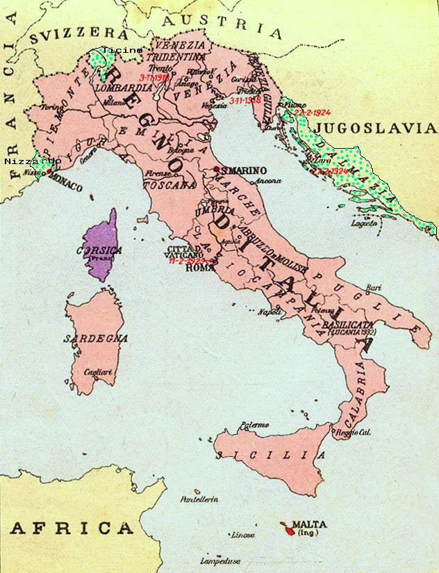
Map of Kingdom of Italy (1919) showing the areas claimed by Irredentism: in red Malta, in purple Corsica, in yellow with green points Dalmatia, Ticino and Nizzardo. I have used as a basic map an old map from an Italian geography and history school book of 1935 "Scuole Medie Inferiori", and I have written and painted on it. Cropped caption: L’Italia dopo la Guerra 1915-1918 |
| Datum | |
| Quälle | Eigeni Arbet |
| Urheber | Brunodambrosio |
| Anderi Versione | File:Nesvobodni rajoni Italija.png |
Lizänzierig
| Public domainPublic domainfalsefalse |
| Ich, dr Urheberrächtsinhaber vu däm Wärch, tue s as gmeinfrej vereffentlige . Des giltet wältwyt. In mänke Staate chennt des rächtli nit megli syy. Wänn des imfall eso isch: Ich gib e jedem s bedingiglos Rächt, des Wärch jedwädere Zwäck z nutze, ußer s git gesetzlig erforderligi Bedingige. |
Kurzbeschreibungen
Ergänze eine einzeilige Erklärung, was diese Datei darstellt.
Unredeemed (irredentist) regions of Italy
Карта Королевства Италия (1919 г.) с указанием территорий, на которые претендует ирредентизм: красным Мальта, фиолетовым Корсика, желтым с зелеными точками Далмация, Тичино и Ниццардо.
In dieser Datei abgebildete Objekte
Motiv
Einige Werte ohne einen Wikidata-Eintrag
Lizenz Tüütsch
April 2008
Quelle der Datei Tüütsch
MIME-Typ Tüütsch
image/jpeg
Dateiversione
Klick uf e Zytpunkt zu aazeige, wie s dert usgsäh het.
| Version vom | Vorschaubild | Mäß | Benutzer | Kommentar | |
|---|---|---|---|---|---|
| aktuell | 23:34, 17. Aug. 2023 | | 632 × 824 (247 KB) | 0m9Ep | Color |
| 12:14, 23. Dez. 2017 |  | 632 × 824 (262 KB) | Julieta39 | Blù delle mare | |
| 00:58, 8. Jun. 2012 |  | 632 × 824 (119 KB) | Ras67 | losslessly cropped with Jpegcrop | |
| 00:01, 17. Apr. 2008 |  | 669 × 903 (144 KB) | Brunodambrosio | {{Information |Description=Map of Kingdom of Italy (1919) showing the areas claimed by Irredentism:in red Malta, in purple Corsica, in yellow with green points Dalmatia, Ticino and Nizzardo. I have used as a basic map an old map from an italian geography |
Verwändig vu dr Datei
Di folgende Sytene händ en Link zu dem Bildli:
Wältwyti Dateinutzig
Die andere Wikis bruche die Datei:
- Gebruch uf ar.wikipedia.org
- Gebruch uf ast.wikipedia.org
- Gebruch uf az.wikipedia.org
- Gebruch uf be-tarask.wikipedia.org
- Gebruch uf be.wikipedia.org
- Gebruch uf ca.wikipedia.org
- Gebruch uf cs.wikipedia.org
- Gebruch uf de.wikipedia.org
- Gebruch uf de.wiktionary.org
- Gebruch uf en.wikipedia.org
- Foreign relations of Italy
- Irredentism
- Italian irredentism
- History of the Kingdom of Italy (1861–1946)
- List of irredentist claims or disputes
- Italian fascism
- Kingdom of Italy
- History of Corsica
- Italian irredentism in Corsica
- Benito Mussolini
- Italian irredentism in Malta
- Italian irredentism in Switzerland
- User:Brothernight/sandbox
- User:Falcaorib/Italy
- Gebruch uf eo.wikipedia.org
- Gebruch uf es.wikipedia.org
- Gebruch uf fa.wikipedia.org
- Gebruch uf fr.wikipedia.org
- Gebruch uf he.wikipedia.org
- Gebruch uf hr.wikipedia.org
- Gebruch uf hu.wikipedia.org
- Gebruch uf hy.wikipedia.org
- Gebruch uf id.wikipedia.org
Wältwyti Verwändig vu däre Datei aaluege.
Metadate
Die Datei het wyteri Informatione, allwäg vor Digitalkamera oder vom Scanner wo se het gschaffe.
We die Datei isch veränderet worde, de cha's sy, das die zuesätzlechi Information für di verändereti Datei nümm richtig zuetrifft.
| Orientierung | Normal |
|---|---|
| Horizontali Uflesig | 96 dpi |
| Vertikali Uflesig | 96 dpi |
| Software | Adobe Photoshop CS3 Macintosh |
| Spycherzytpunkt | 11:13, 23. Dez. 2017 |
| Digitalisierigszytpunkt | 11:09, 23. Dez. 2017 |
| Farbruum | sRGB |
| Datum, wu d Metadate s letscht Mol gänderet wore sin | 12:13, 23. Dez. 2017 |
| IIM-Version | 2 |