Restr:OoNL1786.png
From Wikipedia, the free encyclopedia
OoNL1786.png (565 × 481 piksel, ment ar restr : 539 Kio, seurt MIME : image/png)
![]()
| Tennet eo ar restr-mañ eus Wikimedia Commons ha gallout a ra bezañ implijet evit raktresoù all. Diskouezet eo deskrivadur he fajenn zeskrivañ amañ dindan. |
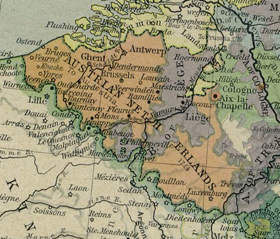
- Description: Cropped version of a map of Europe in 1786. From The Historical Atlas by William R. Shepherd, 1926.
Diverradur
Austrian Netherlands 1786. This picture is from the collection of the University of Texas (http://www.lib.utexas.edu/maps/historical/history_europe.html). These maps are under public domain (http://www.lib.utexas.edu/maps/faq.html#3.html).
Aotre-implijout
| Public domainPublic domainfalsefalse |
|
This work is in the public domain in its country of origin and other countries and areas where the copyright term is the author's life plus 70 years or fewer.
| |
| Rummet eo bet ar restr-mañ e-touez ar restroù hep strishadurioù implij anavezet evit ar pezh a sell ouzh ar gwirioù aozer, ha kement-se evit an holl wirioù kar ha stag. | |
https://creativecommons.org/publicdomain/mark/1.0/PDMCreative Commons Public Domain Mark 1.0falsefalse

|
This old map image could be re-created using vector graphics as an SVG file. This has several advantages; see Commons:Media for cleanup for more information. If an SVG form of this image is available, please upload it and afterwards replace this template with
{{vector version available|new image name}}.
It is recommended to name the SVG file “OoNL1786.svg”—then the template Vector version available (or Vva) does not need the new image name parameter. |
Istor ar restr
Klikañ war un deiziad/eur da welet ar restr evel ma oa da neuze.
| Deiziad/Eur | Munud | Mentoù | Implijer | Notenn | |
|---|---|---|---|---|---|
| red | 4 C'hwe 2006 da 22:31 | | 565 × 481 (539 Kio) | Stullkowski | Austrian Netherlands 1786. This picture is from the collection of the University of Texas (http://www.lib.utexas.edu/maps/). These maps are under public domain (http://www.lib.utexas.edu/maps/faq.html#3.html). |
Implij ar restr
Implijout a ra an 2 pajenn da heul ar restr-mañ :
Implij hollek ar restr
Ober a ra ar wikioù da-heul gant ar restr-mañ :
- Implij war af.wikipedia.org
- Implij war ast.wikipedia.org
- Implij war ca.wikipedia.org
- Implij war cs.wikipedia.org
- Implij war da.wikipedia.org
- Implij war de.wikipedia.org
- Implij war en.wikipedia.org
- Implij war eo.wikipedia.org
- Implij war et.wikipedia.org
- Implij war fi.wikipedia.org
- Implij war fr.wikipedia.org
- Implij war gl.wikipedia.org
- Implij war he.wikipedia.org
- Implij war hu.wikipedia.org
- Implij war it.wikipedia.org
- Implij war ja.wikipedia.org
- Implij war lb.wikipedia.org
- Implij war lmo.wikipedia.org
- Implij war lt.wikipedia.org
- Implij war lv.wikipedia.org
- Implij war ms.wikipedia.org
- Implij war nl.wikipedia.org
Gwelet muioc'h eus implij hollek ar restr-mañ.