Fitxer:California_rivers.jpg
From Wikipedia, the free encyclopedia
Fitxer original (2.506 × 3.022 píxels, mida del fitxer: 1,6 Mo, tipus MIME: image/jpeg)
| Aquest fitxer i la informació mostrada a continuació provenen del dipòsit multimèdia lliure Wikimedia Commons. |
Resum
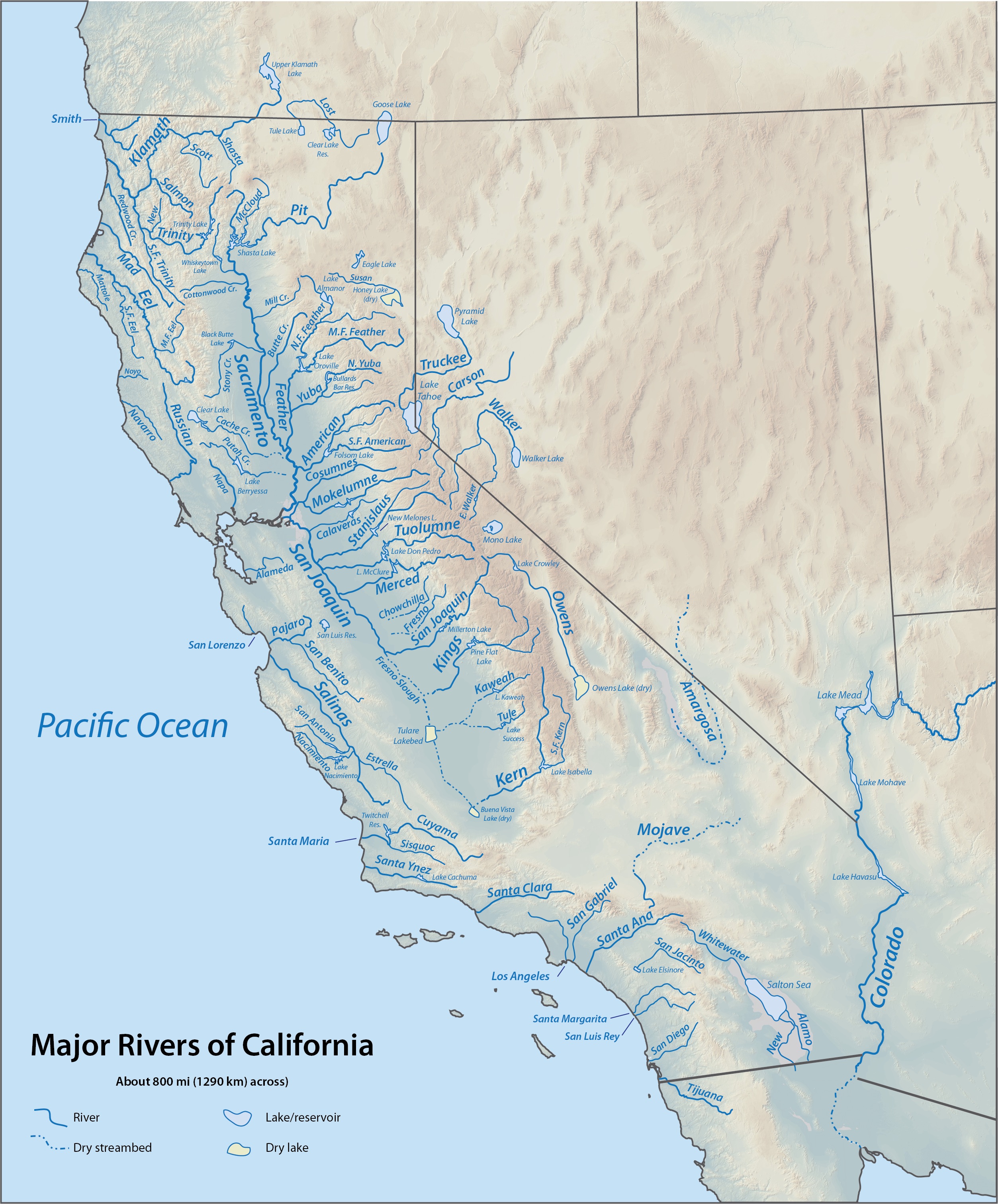
| DescripcióCalifornia rivers.jpg |
English: Map of major rivers in California based on DEMIS Mapserver shaded relief |
| Data | updated 19:57, 6 September 2010 (UTC) |
| Font | Derived from DEMIS map sections copied and assembled together |
| Autor | Me |
Llicència
| Public domainPublic domainfalsefalse |
Aquesta imatge és de domini públic, ja que conté materials que originalment van venir del Servei Geològic dels Estats Units d'Amèrica, una agència del Departament de l'Interior dels Estats Units. Per a obtenir més informació, consulti la política oficial de drets de l'USGS.
Bahasa Indonesia ∙ català ∙ čeština ∙ Deutsch ∙ eesti ∙ English ∙ español ∙ français ∙ galego ∙ italiano ∙ Nederlands ∙ português ∙ polski ∙ sicilianu ∙ suomi ∙ Tiếng Việt ∙ Türkçe ∙ български ∙ македонски ∙ русский ∙ മലയാളം ∙ 한국어 ∙ 日本語 ∙ 中文 ∙ 中文(简体) ∙ 中文(繁體) ∙ العربية ∙ فارسی ∙ +/− |
Registre original de càrregues
- 2010-09-06 03:59 Shannon1 1084×1176× (952304 bytes) forgot to draw a section of the North Feather
- 2010-09-06 03:55 Shannon1 1084×1176× (952303 bytes) change terrain to Demis (also PD), add a few more rivers, fixed some names (possibly)?
- 2010-01-12 03:41 Shannon1 (usurped3) 752×854× (377169 bytes) HOW COULD I HAVE FORGOTTEN TO LABEL THE SACRAMENTO RIVER?!
- 2010-01-12 03:38 Shannon1 (usurped3) 752×854× (373336 bytes) {{Information |Description = Map of major rivers in California based on USGS shaded relief |Source = http://birrell.org/andrew/reliefMaps/, which is derived from USGS DEM (Digital Elevation Module) files assembled together |Date =
Llegendes
Elements representats en aquest fitxer
representa l'entitat
image/jpeg
b38706700a100a806838fa1e29949cd942a899fd
1.676.516 byte
3.022 píxel
2.506 píxel
Historial del fitxer
Cliqueu una data/hora per veure el fitxer tal com era aleshores.
| Data/hora | Miniatura | Dimensions | Usuari/a | Comentari | |
|---|---|---|---|---|---|
| actual | 19:11, 18 oct 2015 | | 2.506 × 3.022 (1,6 Mo) | Shannon1 | changed to higher resolution USGS relief and added a few rivers/lakes, fixed a few labels |
| 03:33, 19 set 2013 |  | 1.084 × 1.176 (930 Ko) | OgreBot | (BOT): Reverting to most recent version before archival | |
| 03:33, 19 set 2013 |  | 1.084 × 1.176 (930 Ko) | OgreBot | (BOT): Uploading old version of file from en.wikipedia; originally uploaded on 2010-09-06 03:55:05 by Shannon1 | |
| 03:33, 19 set 2013 |  | 752 × 854 (368 Ko) | OgreBot | (BOT): Uploading old version of file from en.wikipedia; originally uploaded on 2010-01-12 03:41:42 by Shannon1 (usurped3) | |
| 03:33, 19 set 2013 |  | 752 × 854 (365 Ko) | OgreBot | (BOT): Uploading old version of file from en.wikipedia; originally uploaded on 2010-01-12 03:38:50 by Shannon1 (usurped3) | |
| 17:38, 19 oct 2012 |  | 1.084 × 1.176 (930 Ko) | Urdangaray | {{Information |Description={{en|Map of major rivers in California based on DEMIS Mapserver shaded relief}} |Source=Transferred from [http://en.wikipedia.org en.wikipedia]<br/> (Original text : ''Derived from DEMIS map sections copied and assembled toge... |
Ús del fitxer
La pàgina següent utilitza aquest fitxer:
Ús global del fitxer
Utilització d'aquest fitxer en altres wikis:
- Utilització a bg.wikipedia.org
- Utilització a en.wikipedia.org
- Utilització a es.wikipedia.org
- Utilització a fi.wikipedia.org
- Utilització a nl.wikipedia.org
Metadades
Aquest fitxer conté informació addicional, probablement afegida per la càmera digital o l'escàner utilitzat per a crear-lo o digitalitzar-lo. Si s'ha modificat posteriorment, alguns detalls poden no reflectir les dades reals del fitxer modificat.
| Orientació | Normal |
|---|---|
| Resolució horitzontal | 72 ppp |
| Resolució vertical | 72 ppp |
| Programari utilitzat | Adobe ImageReady |
| Espai de color | sRGB |