File:Europe_1867_map_en.png
From Wikipedia, the free encyclopedia
Velikost tohoto náhledu: 800 × 526 pixelů. Jiná rozlišení: 320 × 211 pixelů | 640 × 421 pixelů | 1 024 × 674 pixelů | 1 280 × 842 pixelů | 2 284 × 1 503 pixelů.
Původní soubor (2 284 × 1 503 pixelů, velikost souboru: 1,07 MB, MIME typ: image/png)
| Tento soubor pochází z Wikimedia Commons. Níže jsou zobrazeny informace, které obsahuje jeho tamější stránka s popisem souboru. |
Popis
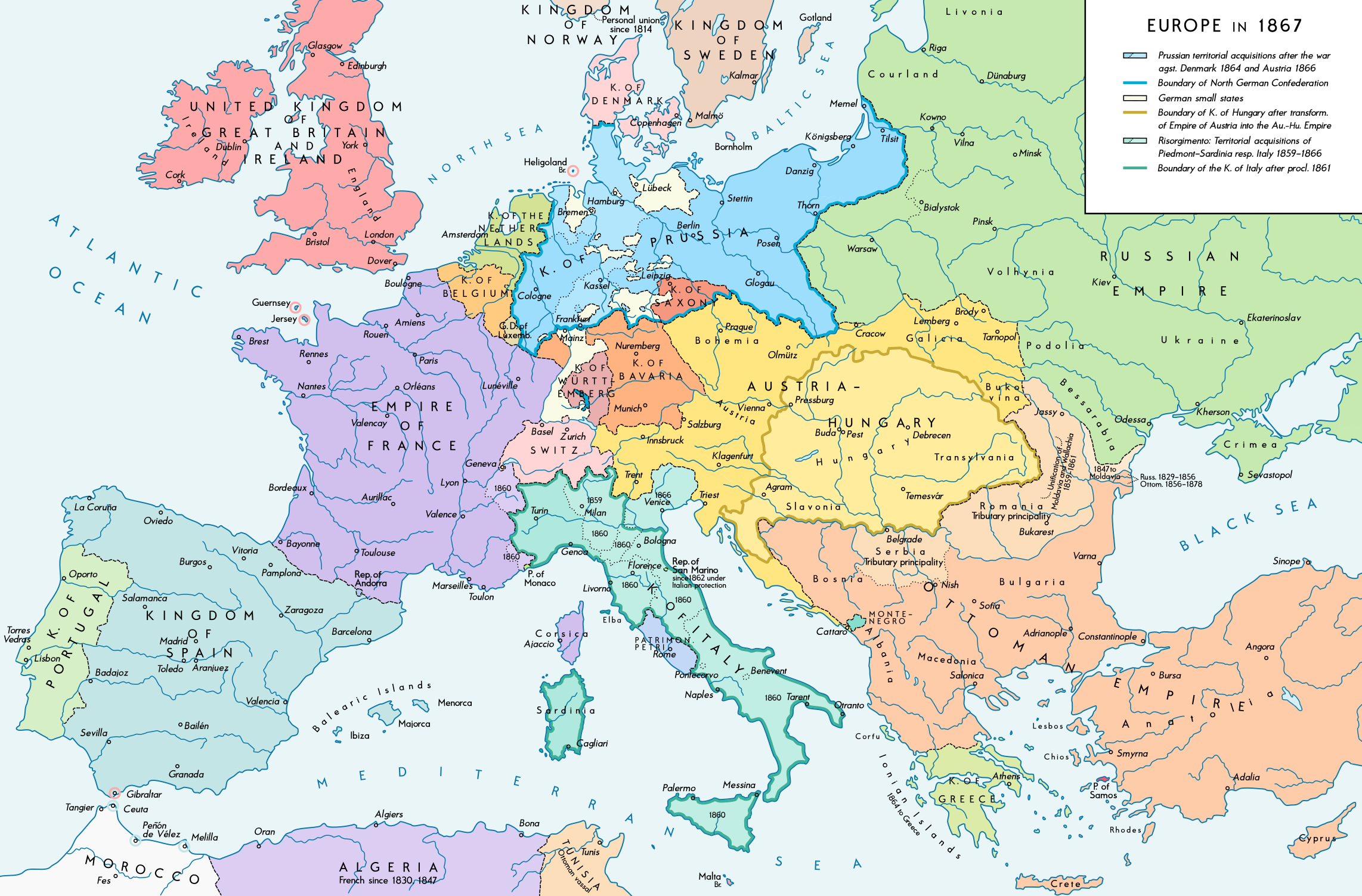
| PopisEurope 1867 map en.png |
English: Europe 1867. Historical map of the political situation after the forming of the North German Confederation, the Italian Risorgimento (with the exception of the Roman part of the Papal States) and the Austro-Hungarian Compromise of 1867. Please don't alter the map, when you think there something not written or depicted correctly. Leave a message at the talk page of the file. After a verificiation and a possible discussion, i will upload a new map version with all new changes. This prevents an unnecessary waste of disc space and ensures a good result, aesthetically and contentwise. - The author. Deutsch: Europa 1867. Historische Karte der politischen Situation in Europa nach der Gründung des Norddeutschen Bundes, des italienischen Risorgimento (mit Ausnahme des röm. Teils des Kirchenstaats) und dem Österreichisch-Ungarischen Ausgleich von 1867. Bitte die Karte bei Änderungs- und Korrekturwünschen nicht selbst verändern, sondern eine Anmerkung im Diskussionsbereich der Bilddatei hinterlassen. Nach einer Prüfung und ggfs. Diskussion werden evtl. Änderungen von mir zusammengefasst eingearbeitet. Das vermeidet unnötige Speicherplatz-Verschwendung und gewährleistet ein ästhetisch ansprechendes und inhaltlich korrektes Ergebnis. - Der Urheber. |
| Datum | |
| Zdroj |
Vlastní dílo. Source of Information: Historical atlases and maps – Ramsay Muir, George Philip (ed.): Philip's New School Atlas of Universal History, George Philip & Son, Ltd., London 1928 – Dr. Walter Leisering (ed.): Putzger Historischer Weltatlas, Cornelsen Verlag, Berlin 1992, ISBN 3-464-00176-8 – Bayerischer Schulbuch-Verlag (ed.): Großer Historischer Weltatlas, Dritter Teil, Neuzeit, Bayerischer Schulbuch-Verlag, München 1981, ISBN 3-7627-6021-7. – Prof. Dr. Vadim Oswalt u. Prof. Dr. Hans Ulrich Rudolf (ed.): Klett-Perthes Atlas zur Weltgeschichte, Ernst Klett Verlag, Stuttgart 2011, ISBN 978-3-12-828194-0 – Ziegelbrenner: Karte des Norddeutschen Bundes 1866–1871, 6 June 2014 version (map link) Other publications – Francesco Traniello u. Gianni Sofri: Der lange Weg zur Nation. Das italienische Risorgimento, Verlag W. Kohlhammer, Stuttgart 2012, ISBN 978-3-17-021898-7 |
| Autor | Alexander Altenhof |
| Další verze |
|

Recompressed without quality loss with OptiPNG (1.35 MB > 1.06 MB)
Licence
Já, držitel autorských práv k tomuto dílu, ho tímto zveřejňuji za podmínek následující licence:
Tento soubor podléhá licenci Creative Commons Uveďte autora-Zachovejte licenci 4.0 International
- Dílo smíte:
- šířit – kopírovat, distribuovat a sdělovat veřejnosti
- upravovat – pozměňovat, doplňovat, využívat celé nebo částečně v jiných dílech
- Za těchto podmínek:
- uveďte autora – Máte povinnost uvést autorství, poskytnout odkaz na licenci a uvést, pokud jste provedli změny. Toho můžete docílit jakýmkoli rozumným způsobem, avšak ne způsobem naznačujícím, že by poskytovatel licence schvaloval nebo podporoval vás nebo vaše užití díla.
- zachovejte licenci – Pokud tento materiál jakkoliv upravíte, přepracujete nebo použijete ve svém díle, musíte své příspěvky šířit pod stejnou nebo slučitelnou licencí jako originál.
Popisky
Přidejte jednořádkové vysvětlení, co tento soubor představuje
Položky vyobrazené v tomto souboru
zobrazuje
Nějaká hodnota bez položky na Wikidatech
4. 9. 2016
Historie souboru
Kliknutím na datum a čas se zobrazí tehdejší verze souboru.
| Datum a čas | Náhled | Rozměry | Uživatel | Komentář | |
|---|---|---|---|---|---|
| současná | 15. 4. 2017, 01:42 | | 2 284 × 1 503 (1,07 MB) | KaterBegemot | Empire of France (not Kingdom), changed main caption to "Europe in 1867", fixed font size of "Piedmont-Sardinia", minor changes |
| 4. 9. 2016, 23:36 |  | 2 284 × 1 503 (1,06 MB) | KaterBegemot | {{Information |Description ={{en|1=Europe 1867. Historical map of the political situation after the forming of the North German Confederation, the Italian Risorgimento (with the exception of the Roman part of the Papal States) and the Austro-Hungari... |
Využití souboru
Tento soubor nepoužívá žádná stránka.
Globální využití souboru
Tento soubor využívají následující wiki:
- Využití na ast.wikipedia.org
- Využití na en.wikipedia.org
- Využití na et.wikipedia.org
- Využití na it.wikipedia.org
Metadata
Tento soubor obsahuje dodatečné informace, poskytnuté zřejmě digitálním fotoaparátem nebo scannerem, kterým byl pořízen. Pokud byl soubor od té doby změněn, některé údaje mohou být neplatné.
| Rozlišení obrázku na šířku | 70 dpi |
|---|---|
| Rozlišení obrázku na výšku | 70 dpi |
| Barevný prostor | Nekalibrováno |
| Šířka obrázku | 2 284 px |
| Výška obrázku | 1 503 px |
| Použitý software | Adobe Photoshop CC 2017 (Windows) |
| Datum a čas digitalizace | 15. 4. 2017, 03:05 |
| Datum a čas vytvoření obrázku | 15. 4. 2017, 03:22 |
| Datum poslední úpravy metadat | 15. 4. 2017, 03:22 |
| Unikátní ID původního dokumentu | xmp.did:fd41fa5f-5199-fd40-bec6-d1a7668cc651 |