Soubor:Beaver_wars_map.jpg
From Wikipedia, the free encyclopedia
Původní soubor (871 × 736 pixelů, velikost souboru: 163 KB, MIME typ: image/jpeg)
| Tento soubor pochází z Wikimedia Commons. Níže jsou zobrazeny informace, které obsahuje jeho tamější stránka s popisem souboru. |
| PopisBeaver wars map.jpg |
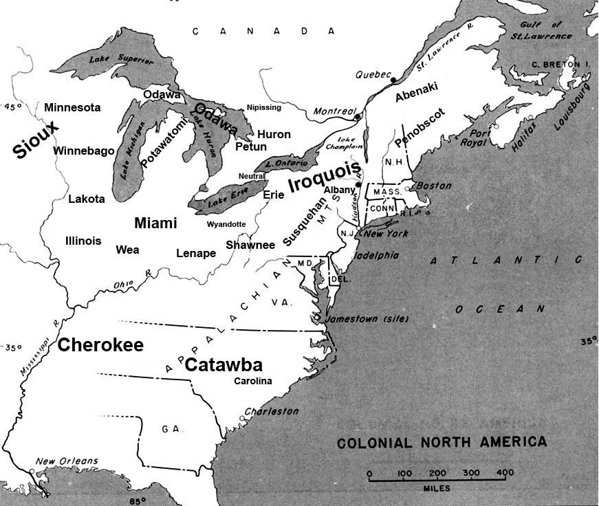
English: Map of the location of major tribes involved in the Beaver Wars laid against a period map showing colonial settlments |
|||
| Datum | ||||
| Zdroj | Vlastní dílo | |||
| Autor | Charles Edward | |||
| Svolení (Užití tohoto souboru) |
|
Info
This represents the approximate configuration of the tribes in 1648. Although the areas are large, the populations were low and large parts of the territories where uninhabited, and instead used as hunting grounds. The tribes were also semi nomadic, and the period was rife with war and several of the tribes on the map were destroyed in the 1650s. The map was made using information in several books incluing:
- Jennings, Francis (1984) The Ambiguous Iroquois Empire ISBN: 0393017192.
- Wallace, Paula W (2007) Indians in Pennsylvania, DIANE Publishing Inc ISBN: 1422314936.
Popisky
Položky vyobrazené v tomto souboru
zobrazuje
Nějaká hodnota bez položky na Wikidatech
image/jpeg
eea8e663c82e0a23525be04d55ebe0491c41e211
167 366 bajt
736 pixel
871 pixel
Historie souboru
Kliknutím na datum a čas se zobrazí tehdejší verze souboru.
| Datum a čas | Náhled | Rozměry | Uživatel | Komentář | |
|---|---|---|---|---|---|
| současná | 19. 11. 2008, 00:34 | | 871 × 736 (163 KB) | Charles Edward | Slight adjustment to name on image |
| 19. 11. 2008, 00:33 |  | 871 × 736 (164 KB) | Charles Edward | {{Information |Description=adjustment of locations per discussion on Beaver War talk page |Source= |Date= |Author= |Permission= |other_versions= }} | |
| 16. 11. 2008, 21:51 |  | 871 × 736 (298 KB) | Charles Edward | {{Information |Description=New version removes borders, ads more ambiguity to the map |Source= |Date= |Author= |Permission= |other_versions= }} | |
| 16. 11. 2008, 04:43 |  | 815 × 472 (275 KB) | Charles Edward | {{Information |Description= |Source= |Date= |Author= |Permission= |other_versions= }} | |
| 16. 11. 2008, 03:16 |  | 815 × 472 (275 KB) | Charles Edward | {{Information |Description=adding tribes, adjusting locations |Source= |Date= |Author= |Permission= |other_versions= }} Category:Maps of the United States | |
| 16. 11. 2008, 02:39 |  | 815 × 472 (270 KB) | Charles Edward | {{Information |Description=Added additional tribes |Source= |Date= |Author= |Permission= |other_versions= }} | |
| 16. 11. 2008, 02:35 |  | 815 × 472 (270 KB) | Charles Edward | {{Information |Description=Added additional tribes |Source= |Date= |Author= |Permission= |other_versions= }} | |
| 16. 11. 2008, 02:14 |  | 815 × 472 (262 KB) | Charles Edward | {{Information |Description={{en|1=Map of the location of major tribes involved in the Beaver Wars laid against a period map showing colonial settlments}} |Source=Own work by uploader |Author=Charles Edward |Date=11-15-8 |Permission |
Využití souboru
Tento soubor používají následující 2 stránky:
Globální využití souboru
Tento soubor využívají následující wiki:
- Využití na azb.wikipedia.org
- Využití na en.wikipedia.org
- Využití na es.wikipedia.org
- Využití na et.wikipedia.org
- Využití na gl.wikipedia.org
- Využití na id.wikipedia.org
- Využití na it.wikipedia.org
- Využití na ja.wikipedia.org
- Využití na lv.wikipedia.org
- Využití na nl.wikipedia.org
- Využití na no.wikipedia.org
- Využití na pl.wikipedia.org
Metadata
Tento soubor obsahuje dodatečné informace, poskytnuté zřejmě digitálním fotoaparátem nebo scannerem, kterým byl pořízen. Pokud byl soubor od té doby změněn, některé údaje mohou být neplatné.
| Orientace | Normální |
|---|---|
| Rozlišení obrázku na šířku | 200 dpi |
| Rozlišení obrázku na výšku | 200 dpi |
| Použitý software | Adobe Photoshop CS2 Windows |
| Datum a čas vytvoření obrázku | 18. 11. 2008, 17:29 |
| Barevný prostor | Nekalibrováno |