File:2019UKElectionMap.svg
From Wikipedia, the free encyclopedia

Size of this PNG preview of this SVG file: 720 × 599 pixels. Other resolutions: 288 × 240 pixels | 577 × 480 pixels | 923 × 768 pixels | 1,230 × 1,024 pixels | 2,460 × 2,048 pixels | 1,248 × 1,039 pixels.
Original file (SVG file, nominally 1,248 × 1,039 pixels, file size: 5.34 MB)
| This is a file from the Wikimedia Commons. Information from its description page there is shown below. Commons is a freely licensed media file repository. You can help. |
Summary
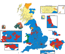
| Description2019UKElectionMap.svg |
English: Map for results of the 2019 general election in the United Kingdom. Ultimately based upon data from the Boundary Commission. Colours are as below.
Français : Carte des résultats des élections générales britanniques de 2019. En fin de compte, d'après les données de la Commission de délimitation des circonscriptions. Les couleurs sont comme ci-dessous.
|
||
| Date | |||
| Source | Own work | ||
| Author | Brythones, recoloured by Ezzatam | ||
| Other versions |
|


Licensing
I, the copyright holder of this work, hereby publish it under the following license:
This file is licensed under the Creative Commons Attribution-Share Alike 4.0 International license.
- You are free:
- to share – to copy, distribute and transmit the work
- to remix – to adapt the work
- Under the following conditions:
- attribution – You must give appropriate credit, provide a link to the license, and indicate if changes were made. You may do so in any reasonable manner, but not in any way that suggests the licensor endorses you or your use.
- share alike – If you remix, transform, or build upon the material, you must distribute your contributions under the same or compatible license as the original.
Captions
2019 UK Election Map
Items portrayed in this file
depicts
some value
29 October 2019
image/svg+xml
b933b46a388742e3b78269ae70dcae5c9a845fb9
5,585,128 byte
1,039 pixel
1,248 pixel
File history
Click on a date/time to view the file as it appeared at that time.
| Date/Time | Thumbnail | Dimensions | User | Comment | |
|---|---|---|---|---|---|
| current | 23:25, 4 March 2024 | | 1,248 × 1,039 (5.34 MB) | PoliticsMaps | File uploaded using svgtranslate tool (https://svgtranslate.toolforge.org/). Added translation for cy. |
| 22:52, 4 March 2024 |  | 1,248 × 1,039 (5.34 MB) | PoliticsMaps | File uploaded using svgtranslate tool (https://svgtranslate.toolforge.org/). Added translation for fr. | |
| 17:41, 13 December 2019 |  | 1,248 × 1,039 (5.33 MB) | Ketrit | Fixed undeclared seat in insert with text editor. | |
| 17:02, 13 December 2019 |  | 1,248 × 1,039 (5.33 MB) | Bellezzasolo | Unique ids (from 2017 version), constituencies now identified by name parameter. | |
| 15:20, 13 December 2019 |  | 1,248 × 1,039 (5.3 MB) | Ketrit | St. Ives declares. | |
| 15:11, 13 December 2019 |  | 1,248 × 1,039 (5.3 MB) | Ketrit | Fixed more insert box weirdness. | |
| 14:43, 13 December 2019 |  | 1,248 × 1,039 (5.29 MB) | Ketrit | Fixes in cutout fills. | |
| 13:22, 13 December 2019 |  | 1,248 × 1,039 (5.29 MB) | RaviC | Arundel & S Downs | |
| 08:14, 13 December 2019 |  | 1,248 × 1,039 (5.26 MB) | Bellezzasolo | 648/650 constituencies. Color is done using CSS classes, which makes programattic access easier | |
| 07:02, 13 December 2019 |  | 1,248 × 1,039 (5.5 MB) | Ezzatam | 646/650 seats, fixed minor errors |
File usage
The following pages on the English Wikipedia use this file (pages on other projects are not listed):
- 2019 United Kingdom general election
- Brexit
- Early Parliamentary General Election Act 2019
- List of parliamentary constituencies in Hertfordshire
- Premiership of Boris Johnson
- Stoke-on-Trent Central (UK Parliament constituency)
- User:Agc49141/PHAltHist
- User:AlSmith28/2019 Austrian legislative election
- User:Biglittlehugesmall65/sandbox
- User:Boomudo/sandbox
- User:Patrick Star Fan 8845/sandbox
- User:PierrePoilievreFan101/sandbox
- User:Rpryor03/sandbox
- User:SKC200/sandbox
- User:Seafoxlrt616/sandbox
- User:Sir Gregory Stephenson/Sandbox
- User:SushiGod/sandbox/arnisoua
Global file usage
The following other wikis use this file:
- Usage on ar.wikipedia.org
- Usage on ca.wikipedia.org
- Usage on ca.wikinews.org
- Usage on cs.wikipedia.org
- Usage on cy.wikipedia.org
- Usage on da.wikipedia.org
- Usage on el.wikipedia.org
- Usage on en.wikinews.org
- Usage on es.wikipedia.org
- Usage on eu.wikipedia.org
- Usage on fa.wikipedia.org
- Usage on fi.wikipedia.org
- Usage on fr.wikipedia.org
- Usage on fr.wikinews.org
- Usage on ga.wikipedia.org
- Usage on hu.wikipedia.org
- Usage on id.wikipedia.org
- Usage on it.wikipedia.org
- Usage on ja.wikipedia.org
- Usage on ko.wikipedia.org
- Usage on kw.wikipedia.org
- Usage on li.wikinews.org
- Usage on lv.wikipedia.org
- Usage on ms.wikipedia.org
- Usage on nl.wikipedia.org
- Usage on nl.wikinews.org
- Usage on pt.wikipedia.org
- Usage on ro.wikipedia.org
- Usage on ru.wikinews.org
- Usage on sco.wikipedia.org
- Usage on simple.wikipedia.org
- Usage on sr.wikipedia.org
- Usage on sv.wikipedia.org
- Usage on ta.wikipedia.org
- Usage on th.wikipedia.org
- Usage on tr.wikipedia.org
- Usage on uk.wikipedia.org
- Usage on vi.wikipedia.org
- Usage on www.wikidata.org
- Usage on zh.wikipedia.org
Metadata
This file contains additional information, probably added from the digital camera or scanner used to create or digitize it.
If the file has been modified from its original state, some details may not fully reflect the modified file.
| Width | 1247.5764 |
|---|---|
| Height | 1038.9133 |
Retrieved from "https://en.wikipedia.org/wiki/File:2019UKElectionMap.svg"