File:Biafra_independent_state_map-en.svg
From Wikipedia, the free encyclopedia

Size of this PNG preview of this SVG file: 776 × 600 pixels. Other resolutions: 311 × 240 pixels | 621 × 480 pixels | 994 × 768 pixels | 1,280 × 989 pixels | 2,560 × 1,978 pixels | 1,100 × 850 pixels.
Original file (SVG file, nominally 1,100 × 850 pixels, file size: 472 KB)
| This is a file from the Wikimedia Commons. Information from its description page there is shown below. Commons is a freely licensed media file repository. You can help. |
| This SVG file contains embedded text that can be translated into your language, using any capable SVG editor, text editor or the SVG Translate tool. For more information see: About translating SVG files. |
Summary
| DescriptionBiafra independent state map-en.svg |
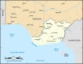
Català: Mapa de la república de Biafra en el maig 1967. English: Map of the secessionist state of the Republic of Biafra (1967 – 1970) as in May 1967. Note: The western boundary may not be accurate due to the low precision of the reference maps used which are also contradictory. Français : Carte en anglais de l'État sécessionniste de la République du Biafra (1967 – 1970) telle qu'en mai 1967. Note : La frontière Ouest peut ne pas être précise en raison de l'imprécision des cartes de référence qui sont aussi contradictoires. UTM projection ; WGS 84 datum |
||
| Date | September 2008 (new version) | ||
| Source |
Own work
|
||
| Author | Eric Gaba (Sting - fr:Sting) | ||
| Permission (Reusing this file) |
|
||
| Other versions |
[edit]
|


| This SVG file contains embedded text that can be translated into your language, using any capable SVG editor, text editor or the SVG Translate tool. For more information see: About translating SVG files. |
This map was improved or created by the Wikigraphists of the Graphic Lab (fr). You can propose images to clean up, improve, create or translate as well. |
Licensing
I, the copyright holder of this work, hereby publish it under the following licenses:

|
Permission is granted to copy, distribute and/or modify this document under the terms of the GNU Free Documentation License, Version 1.2 or any later version published by the Free Software Foundation; with no Invariant Sections, no Front-Cover Texts, and no Back-Cover Texts. A copy of the license is included in the section entitled GNU Free Documentation License.http://www.gnu.org/copyleft/fdl.htmlGFDLGNU Free Documentation Licensetruetrue |
| This file is licensed under the Creative Commons Attribution-Share Alike 3.0 Unported license. | ||
| ||
| This licensing tag was added to this file as part of the GFDL licensing update.http://creativecommons.org/licenses/by-sa/3.0/CC BY-SA 3.0Creative Commons Attribution-Share Alike 3.0truetrue |
This file is licensed under the Creative Commons Attribution-Share Alike 2.5 Generic, 2.0 Generic and 1.0 Generic license.
- You are free:
- to share – to copy, distribute and transmit the work
- to remix – to adapt the work
- Under the following conditions:
- attribution – You must give appropriate credit, provide a link to the license, and indicate if changes were made. You may do so in any reasonable manner, but not in any way that suggests the licensor endorses you or your use.
- share alike – If you remix, transform, or build upon the material, you must distribute your contributions under the same or compatible license as the original.
You may select the license of your choice.
Captions
Map of the secessionist state of the Republic of Biafra (1967–1970) as in May 1967
Mapa de la república de Biafra el maig de 1967
Selles failis kujutatud üksused
depicts
image/svg+xml
bd91cec9f1ee277e93a508626d2f50b3ce7a7fc8
483,714 byte
850 pixel
1,100 pixel
File history
Click on a date/time to view the file as it appeared at that time.
| Date/Time | Thumbnail | Dimensions | User | Comment | |
|---|---|---|---|---|---|
| current | 19:21, 15 September 2023 | | 1,100 × 850 (472 KB) | Glrx | 256 kB workaround // Editing SVG source code using c:User:Rillke/SVGedit.js |
| 10:59, 15 September 2023 |  | 1,100 × 850 (472 KB) | KajenCAT | File uploaded using svgtranslate tool (https://svgtranslate.toolforge.org/). Added translation for ca. | |
| 04:51, 3 September 2008 |  | 1,100 × 850 (455 KB) | Sting | New version using the NGDC GSHHS and WDBII data ; new standard colors | |
| 17:54, 12 December 2006 |  | 1,100 × 850 (163 KB) | Sting | {{Information| |Description=Map of the secessionist state of the Republic of Biafra (1967 – 1970) |Source=Own work<br/>Background reference map : Microsoft Encarta atlas (1999 edition)<br/>Biafra independent state borders reference maps : [http://www.bi |
File usage
The following pages on the English Wikipedia use this file (pages on other projects are not listed):
Global file usage
The following other wikis use this file:
- Usage on af.wikipedia.org
- Usage on ar.wikipedia.org
- Usage on ast.wikipedia.org
- Usage on azb.wikipedia.org
- Usage on be.wikipedia.org
- Usage on bn.wikipedia.org
- Usage on br.wikipedia.org
- Usage on ca.wikipedia.org
- Usage on cs.wikipedia.org
- Usage on da.wikipedia.org
- Usage on el.wikipedia.org
- Usage on eo.wikipedia.org
- Usage on es.wikipedia.org
- Usage on et.wikipedia.org
- Usage on eu.wikipedia.org
- Usage on fa.wikipedia.org
- Usage on gl.wikipedia.org
- Usage on ha.wikipedia.org
- Usage on he.wikipedia.org
- Usage on hu.wikipedia.org
- Usage on hy.wikipedia.org
- Usage on id.wikipedia.org
- Usage on ig.wikipedia.org
- Usage on io.wikipedia.org
- Usage on is.wikipedia.org
- Usage on ja.wikipedia.org
- Usage on jv.wikipedia.org
- Usage on ko.wikipedia.org
- Usage on lt.wikipedia.org
- Usage on ms.wikipedia.org
- Usage on nl.wikipedia.org
- Usage on nn.wikipedia.org
- Usage on no.wikipedia.org
- Usage on pa.wikipedia.org
- Usage on pl.wikipedia.org
View more global usage of this file.
Metadata
This file contains additional information, probably added from the digital camera or scanner used to create or digitize it.
If the file has been modified from its original state, some details may not fully reflect the modified file.
| Width | 1100 |
|---|---|
| Height | 850 |