File:District_map_of_Saint_Helena.png
From Wikipedia, the free encyclopedia
Size of this preview: 727 × 600 pixels. Other resolutions: 291 × 240 pixels | 582 × 480 pixels | 743 × 613 pixels.
Original file (743 × 613 pixels, file size: 48 KB, MIME type: image/png)
| This is a file from the Wikimedia Commons. Information from its description page there is shown below. Commons is a freely licensed media file repository. You can help. |

|
This map image could be re-created using vector graphics as an SVG file. This has several advantages; see Commons:Media for cleanup for more information. If an SVG form of this image is available, please upload it and afterwards replace this template with
{{vector version available|new image name}}.
It is recommended to name the SVG file “District map of Saint Helena.svg”—then the template Vector version available (or Vva) does not need the new image name parameter. |
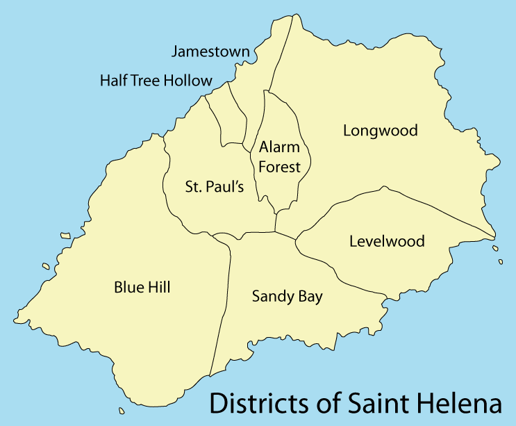
| DescriptionDistrict map of Saint Helena.png |
Deutsch: Karte Distrikte auf St. Helena
English: District map of Saint Helena |
| Date | |
| Source | Own work, using (1) and (2) |
| Author | Maximilian Dörrbecker (Chumwa) |
| Permission (Reusing this file) |
I, the copyright holder of this work, hereby publish it under the following license: This file is licensed under the Creative Commons Attribution-Share Alike 3.0 Unported license.
Sie dürfen das Bild zu den folgenden Bedingungen nutzen:
|
Captions
Add a one-line explanation of what this file represents
Distriktkarte St. Helenas
Items portrayed in this file
depicts
August 2009
image/png
File history
Click on a date/time to view the file as it appeared at that time.
| Date/Time | Thumbnail | Dimensions | User | Comment | |
|---|---|---|---|---|---|
| current | 20:10, 1 August 2009 | | 743 × 613 (48 KB) | Chumwa | {{Information |Description= {{ de }} Karte Distrikte auf St. Helena {{ en }} District map of Saint Helena |Source={{Own}}, using (1) and [http://issuu.com/magma/docs/full_document_final/188 (2)] |Date=2009-08 |Author= [[:de:User:Ch |
File usage
The following pages on the English Wikipedia use this file (pages on other projects are not listed):
Global file usage
The following other wikis use this file:
- Usage on af.wikipedia.org
- Usage on ast.wikipedia.org
- Usage on bn.wikipedia.org
- Usage on ckb.wikipedia.org
- Usage on co.wikipedia.org
- Usage on de.wikipedia.org
- Usage on es.wikipedia.org
- Usage on eu.wikipedia.org
- Usage on fa.wikipedia.org
- Usage on fr.wikipedia.org
- Usage on gv.wikipedia.org
- Usage on hi.wiktionary.org
- Usage on hu.wikipedia.org
- Usage on id.wikipedia.org
- Usage on is.wikipedia.org
- Usage on it.wikipedia.org
- Usage on ka.wikipedia.org
- Usage on no.wikipedia.org
- Usage on oc.wikipedia.org
- Usage on ru.wikipedia.org
- Usage on simple.wikipedia.org
- Usage on sr.wikipedia.org
- Usage on tr.wikipedia.org
- Usage on tt.wikipedia.org
- Usage on ur.wikipedia.org
- Usage on www.wikidata.org
View more global usage of this file.
Retrieved from "https://en.wikipedia.org/wiki/File:District_map_of_Saint_Helena.png"