File:Iowa_rainfall.jpg
From Wikipedia, the free encyclopedia
Original file (844 × 561 pixels, file size: 67 KB, MIME type: image/jpeg)
| This is a file from the Wikimedia Commons. Information from its description page there is shown below. Commons is a freely licensed media file repository. You can help. |

|
This image (or all images in this category) uses inside labels or attached captions in a specific script or language and should be converted to a language neutral form. This would allow its use in all Wikimedia projects and, more importantly, all Wikimedia languages.
Bahasa Melayu ∙ català ∙ čeština ∙ Deutsch ∙ English ∙ español ∙ français ∙ italiano ∙ magyar ∙ Nederlands ∙ Plattdüütsch ∙ português ∙ sicilianu ∙ slovenčina ∙ suomi ∙ беларуская (тарашкевіца) ∙ македонски ∙ русский ∙ српски / srpski ∙ 한국어 ∙ 日本語 ∙ 中文 ∙ 中文(简体) ∙ فارسی ∙ +/− |
Most users around the world are not used to inches for precipitations, adding millimeters would be useful.
Summary
| DescriptionIowa rainfall.jpg |
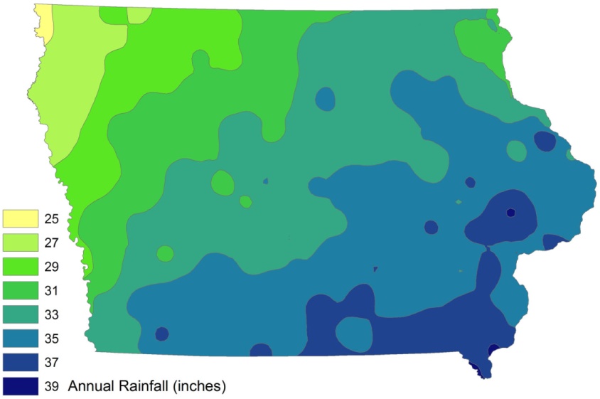
English: Iowa annual fainfall, in inches, created in ESRI ArcMap 9 from ISU-GIS- REF data, utimately from Iowa DNR and state climatologist data. |
| Date | 31 March 2009 (original upload date) |
| Source | I created this work entirely by myself. |
| Author | Bill Whittaker (talk) |
Licensing
| Public domainPublic domainfalsefalse |
| This work has been released into the public domain by its author, Billwhittaker at English Wikipedia. This applies worldwide. In some countries this may not be legally possible; if so: Billwhittaker grants anyone the right to use this work for any purpose, without any conditions, unless such conditions are required by law.Public domainPublic domainfalsefalse |
Original upload log
| Date/Time | Dimensions | User | Comment |
|---|---|---|---|
| 2009-04-01 02:00 | 844×561× (68886 bytes) | CTF83! | == Summary == {{Information |Description = Iowa annual fainfall, in inches, created in ESRI ArcMap 9 from ISU-GIS- REF data, utimately from Iowa DNR and state climatologist data. |Source = I created this work entirely by myself. |Date |
| 2009-03-31 21:24 | 1500×997× (100075 bytes) | Billwhittaker | {{Information |Description = Iowa annual fainfall, in inches, created in ESRI ArcMap 9 from ISU-GIS- REF data, utimately from Iowa DNR and state climatologist data. |Source = I created this work entirely by myself. |Date = |Auth |
Captions
Items portrayed in this file
depicts
31 March 2009
File history
Click on a date/time to view the file as it appeared at that time.
| Date/Time | Thumbnail | Dimensions | User | Comment | |
|---|---|---|---|---|---|
| current | 01:23, 10 January 2017 | | 844 × 561 (67 KB) | BD2412 | Transferred from en.wikipedia |
File usage
Global file usage
The following other wikis use this file:
- Usage on gu.wikipedia.org
- Usage on ja.wikipedia.org
- Usage on kn.wikipedia.org
- Usage on zh.wikipedia.org
Metadata
This file contains additional information, probably added from the digital camera or scanner used to create or digitize it.
If the file has been modified from its original state, some details may not fully reflect the modified file.
| Orientation | Normal |
|---|---|
| Horizontal resolution | 300 dpi |
| Vertical resolution | 300 dpi |
| Software used | Paint.NET v3.36 |
| File change date and time | 16:21, 31 March 2009 |
| Color space | Uncalibrated |