File:Miners'_Tribute_by_Antony_Dufort_-_geograph.org.uk_-_729497.jpg
From Wikipedia, the free encyclopedia
Size of this preview: 450 × 600 pixels. Other resolutions: 180 × 240 pixels | 480 × 640 pixels.
Original file (480 × 640 pixels, file size: 143 KB, MIME type: image/jpeg)
| This is a file from the Wikimedia Commons. Information from its description page there is shown below. Commons is a freely licensed media file repository. You can help. |
Summary
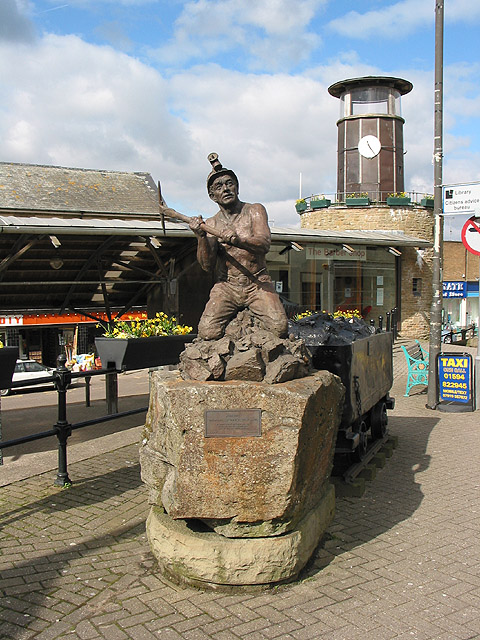
| DescriptionMiners' Tribute by Antony Dufort - geograph.org.uk - 729497.jpg |
English: Miners' Tribute by Antony Dufort In the area of Cinderford known as The Triangle is Dufort's superb sculpture. Coal mining was one of the area's main industries until the last of five large mines closed in 1965. Mining is still undertaken at a few small mines operated by Freeminers. The centuries old mining rights which applied to iron ore, coal and other minerals and even quarrying for stone, entitle any male born within the hundred of St Briavels, aged 21 or more and who has worked for a year and a day in a mine to legally register as a Freeminer. |
| Date | |
| Source | From geograph.org.uk |
| Author | Pauline Eccles |
| Camera location | 51° 49′ 28″ N, 2° 29′ 57″ W | View this and other nearby images on: OpenStreetMap |
|---|
| Object location | 51° 49′ 28″ N, 2° 29′ 59″ W | View this and other nearby images on: OpenStreetMap |
|---|
Licensing

|
This image was taken from the Geograph project collection. See this photograph's page on the Geograph website for the photographer's contact details. The copyright on this image is owned by Pauline Eccles and is licensed for reuse under the Creative Commons Attribution-ShareAlike 2.0 license.
|
This file is licensed under the Creative Commons Attribution-Share Alike 2.0 Generic license.
Attribution: Pauline Eccles
- You are free:
- to share – to copy, distribute and transmit the work
- to remix – to adapt the work
- Under the following conditions:
- attribution – You must give appropriate credit, provide a link to the license, and indicate if changes were made. You may do so in any reasonable manner, but not in any way that suggests the licensor endorses you or your use.
- share alike – If you remix, transform, or build upon the material, you must distribute your contributions under the same or compatible license as the original.
Captions
Add a one-line explanation of what this file represents
Items portrayed in this file
depicts
some value
17 March 2008
51°49'27.55"N, 2°29'57.48"W
51°49'28.20"N, 2°29'58.56"W
image/jpeg
File history
Click on a date/time to view the file as it appeared at that time.
| Date/Time | Thumbnail | Dimensions | User | Comment | |
|---|---|---|---|---|---|
| current | 05:11, 19 February 2011 | | 480 × 640 (143 KB) | GeographBot | == {{int:filedesc}} == {{Information |description={{en|1=Miners' Tribute by Antony Dufort In the area of Cinderford known as The Triangle is Dufort's superb sculpture. Coal mining was one of the areas main industries until the last of the five mines clo |
File usage
The following pages on the English Wikipedia use this file (pages on other projects are not listed):
Global file usage
The following other wikis use this file:
- Usage on arz.wikipedia.org
- Usage on azb.wikipedia.org
- Usage on ca.wikipedia.org
- Usage on ceb.wikipedia.org
- Usage on cy.wikipedia.org
- Usage on en.wikivoyage.org
- Usage on es.wikipedia.org
- Usage on fa.wikipedia.org
- Usage on fr.wikipedia.org
- Usage on ga.wikipedia.org
- Usage on it.wikipedia.org
- Usage on lld.wikipedia.org
- Usage on nl.wikipedia.org
- Usage on nn.wikipedia.org
- Usage on no.wikipedia.org
- Usage on pl.wikipedia.org
- Usage on pt.wikipedia.org
- Usage on ro.wikipedia.org
- Usage on simple.wikipedia.org
- Usage on szl.wikipedia.org
- Usage on vo.wikipedia.org
- Usage on www.wikidata.org
- Usage on zh.wikipedia.org
Metadata
This file contains additional information, probably added from the digital camera or scanner used to create or digitize it.
If the file has been modified from its original state, some details may not fully reflect the modified file.
| _error | 0 |
|---|