File:Rail_transport_map_of_Saudi_Arabia.png
From Wikipedia, the free encyclopedia
Size of this preview: 734 × 599 pixels. Other resolutions: 294 × 240 pixels | 588 × 480 pixels | 941 × 768 pixels | 1,254 × 1,024 pixels | 1,977 × 1,614 pixels.
Original file (1,977 × 1,614 pixels, file size: 417 KB, MIME type: image/png)
| This is a file from the Wikimedia Commons. Information from its description page there is shown below. Commons is a freely licensed media file repository. You can help. |
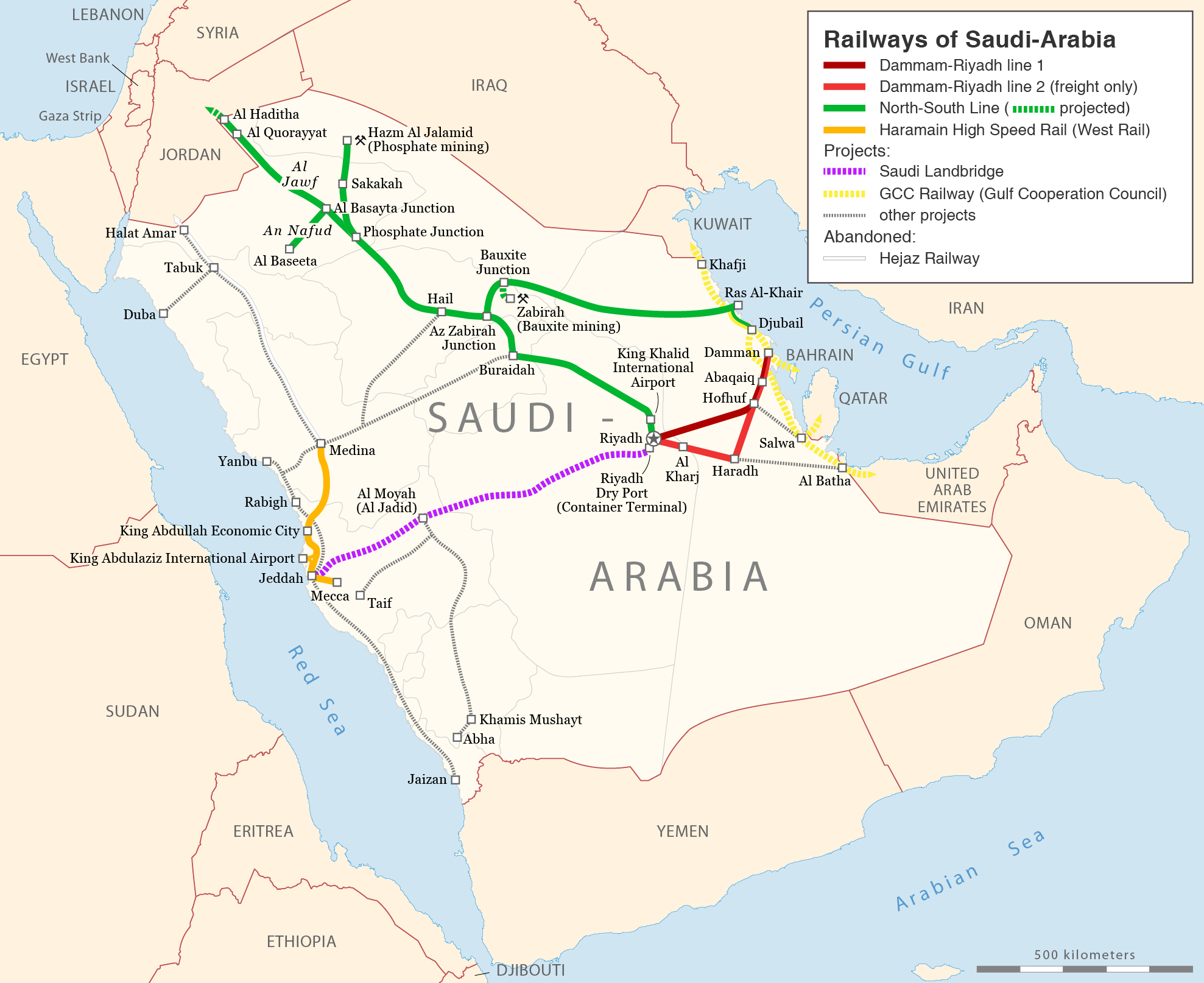
| DescriptionRail transport map of Saudi Arabia.png |
العربية: خريطة لشبكة سكة الحديد السعودية
Deutsch: Eisenbahnkarte von Saudi-Arabien
English: Railway map of Saudi Arabia |
| Date | |
| Source | Self made, using this file |
| Author | Maximilian Dörrbecker (Chumwa) |
| Permission (Reusing this file) |
I, the copyright holder of this work, hereby publish it under the following license: This file is licensed under the Creative Commons Attribution-Share Alike 2.5 Generic license.
Sie dürfen das Bild zu den folgenden Bedingungen nutzen:
|
| Other versions |
|


.svg)
Captions
Add a one-line explanation of what this file represents
Items portrayed in this file
depicts
File history
Click on a date/time to view the file as it appeared at that time.
| Date/Time | Thumbnail | Dimensions | User | Comment | |
|---|---|---|---|---|---|
| current | 20:19, 23 November 2018 | | 1,977 × 1,614 (417 KB) | Chumwa | corr |
| 18:56, 2 October 2018 |  | 1,977 × 1,614 (417 KB) | Chumwa | update | |
| 15:37, 10 June 2017 |  | 1,977 × 1,614 (419 KB) | Chumwa | ||
| 16:10, 9 June 2017 |  | 1,483 × 1,210 (271 KB) | Chumwa | {{Information |Description= |Source= |Date= |Author= |Permission= |other_versions= }} | |
| 18:50, 8 June 2017 |  | 1,483 × 1,210 (268 KB) | Chumwa | update | |
| 19:15, 16 June 2015 |  | 1,483 × 1,210 (275 KB) | Chumwa | update | |
| 19:00, 13 December 2011 |  | 1,483 × 1,210 (272 KB) | Chumwa | Ras Al-Zour in Ras Al-Khair umbenannt, kleinere Streckenanpassungen | |
| 22:40, 21 September 2009 |  | 1,483 × 1,210 (278 KB) | Chumwa | Diverse Änderungen und Erweiterungen | |
| 21:20, 20 September 2009 |  | 1,483 × 1,210 (249 KB) | Chumwa | {{Information |Description= {{ de }} Eisenbahnkarte von Saudi-Arabien {{ en }} Railway map of Saudi Arabia |Source=Self made, using this file |Date=2009-09 |Author= Maximilian Dörrbecker |
File usage
The following pages on the English Wikipedia use this file (pages on other projects are not listed):
Global file usage
The following other wikis use this file:
- Usage on bn.wikipedia.org
- Usage on da.wikipedia.org
- Usage on de.wikipedia.org
- Usage on es.wikipedia.org
- Usage on fr.wikipedia.org
- Usage on hu.wikipedia.org
- Usage on ja.wikipedia.org
- Usage on ml.wikipedia.org
- Usage on pl.wikipedia.org
- Usage on pnb.wikipedia.org
- Usage on pt.wikipedia.org
- Usage on ru.wikipedia.org
- Usage on uk.wikipedia.org
- Usage on ur.wikipedia.org
- Usage on www.wikidata.org
Metadata
This file contains additional information, probably added from the digital camera or scanner used to create or digitize it.
If the file has been modified from its original state, some details may not fully reflect the modified file.
| Horizontal resolution | 314.96 dpc |
|---|---|
| Vertical resolution | 314.96 dpc |
| Software used |