File:River_Niger_Tributaries_from_Benin_OSM.png
From Wikipedia, the free encyclopedia
Size of this preview: 664 × 600 pixels. Other resolutions: 266 × 240 pixels | 531 × 480 pixels | 850 × 768 pixels | 1,134 × 1,024 pixels | 2,172 × 1,962 pixels.
Original file (2,172 × 1,962 pixels, file size: 6.12 MB, MIME type: image/png)
| This is a file from the Wikimedia Commons. Information from its description page there is shown below. Commons is a freely licensed media file repository. You can help. |
Summary
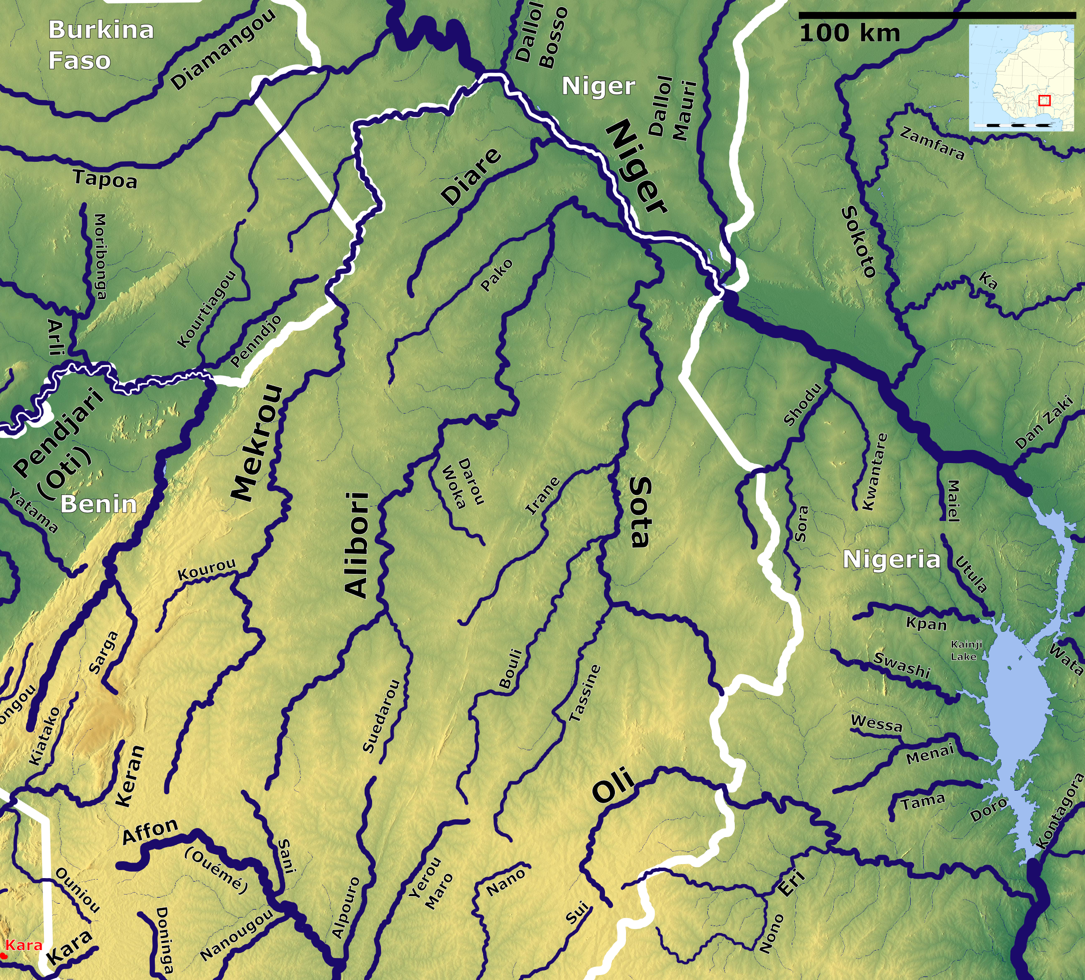
| DescriptionRiver Niger Tributaries from Benin OSM.png |
English: River Niger Tributaries from Benin OSM. Based on US military map NC31 |
| Date | |
| Source | https://maps-for-free.com, http://legacy.lib.utexas.edu/maps/ams/africa_1m/, Location map:https://commons.wikimedia.org/wiki/File:Africa_location_map.svg |
| Author | Hans Braxmeier & Peter in s, Location map:Sting |
| Other versions | https://commons.wikimedia.org/wiki/File:Rivers_of_Benin_and_Togo_OSM.svg |
This file is licensed under the Creative Commons Attribution-Share Alike 3.0 Unported license.
- You are free:
- to share – to copy, distribute and transmit the work
- to remix – to adapt the work
- Under the following conditions:
- attribution – You must give appropriate credit, provide a link to the license, and indicate if changes were made. You may do so in any reasonable manner, but not in any way that suggests the licensor endorses you or your use.
- share alike – If you remix, transform, or build upon the material, you must distribute your contributions under the same or compatible license as the original.
Captions
Add a one-line explanation of what this file represents
Items portrayed in this file
depicts
16 July 2021
image/png
4f6ec875f75a0504f32518ebf0a680cbf495d1ee
6,422,109 byte
1,962 pixel
2,172 pixel
File history
Click on a date/time to view the file as it appeared at that time.
| Date/Time | Thumbnail | Dimensions | User | Comment | |
|---|---|---|---|---|---|
| current | 08:43, 17 July 2021 | | 2,172 × 1,962 (6.12 MB) | Peter in s | Minor Corrections |
| 12:33, 16 July 2021 |  | 2,172 × 1,962 (6.12 MB) | Peter in s | Border | |
| 12:29, 16 July 2021 |  | 2,172 × 1,962 (6.16 MB) | Peter in s | == {{int:filedesc}} == {{Information |Description= {{en|1=River Niger Tributaries from Benin OSM. Based on US military map NC31}} |Source= https://maps-for-free.com, http://legacy.lib.utexas.edu/maps/ams/africa_1m/ |Date= 2021-07-16 |Author= Hans Braxmeier & Peter in s |Permission= |other_versions= }} {{cc-by-sa-2.0}} Category:Maps of rivers of Benin Category:Maps of the Niger Drainage basin |
File usage
The following pages on the English Wikipedia use this file (pages on other projects are not listed):
Global file usage
The following other wikis use this file:
- Usage on arz.wikipedia.org
- Usage on ca.wikipedia.org
- Usage on ceb.wikipedia.org
- Usage on de.wikipedia.org
- Usage on el.wikipedia.org
- Usage on eo.wikipedia.org
- Usage on es.wikipedia.org
- Usage on fr.wikipedia.org
- Usage on ha.wikipedia.org
- Usage on hr.wikipedia.org
- Usage on meta.wikimedia.org
- Usage on pl.wikipedia.org
- Usage on pt.wikipedia.org
- Usage on sw.wikipedia.org
- Usage on www.wikidata.org
Metadata
This file contains additional information, probably added from the digital camera or scanner used to create or digitize it.
If the file has been modified from its original state, some details may not fully reflect the modified file.
| Horizontal resolution | 35.03 dpc |
|---|---|
| Vertical resolution | 35.03 dpc |
| Software used |