Fitxategi:Map_Burgundian_Netherlands_1477-en.png
From Wikipedia, the free encyclopedia
- Fitxategia
- Fitxategiaren historia
- Irudira dakarten loturak
- Fitxategiaren erabilera orokorra
- Metadatuak
Bereizmen handikoa ((1.123 × 1.249 pixel, fitxategiaren tamaina: 825 KB, MIME mota: image/png))
Fitxategi hau Wikimedia Commonsekoa da. Hango deskribapen orriko informazioa behean duzu. |
Laburpena
| DeskribapenaMap Burgundian Netherlands 1477-en.png |
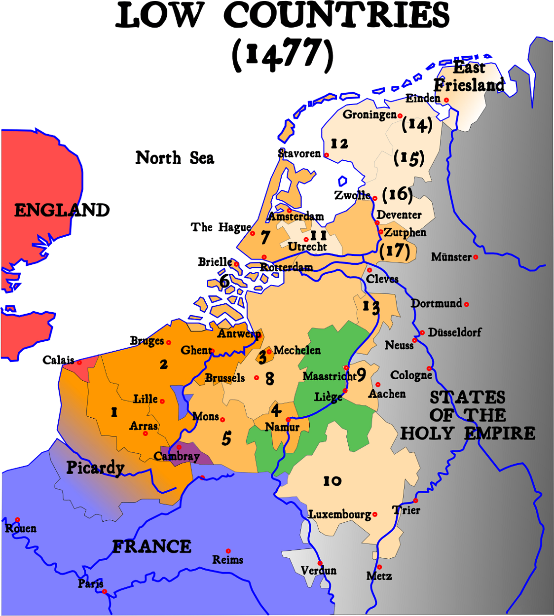
English: Map of Burgundian Netherlands (the Low Countries) in 1477.
Nederlands: Kaart van de Bourgondische Nederlanden (de Lage Landen) in 1477. |
| Jatorria |
English version of Image:1477 Pays-bas bourguignons.svg (see legend there)
|
| Egilea | Denis Jacquerye |
| Beste bertsioak |
[aldatu]
|


Key
- In orange, the acquisitions of the dukes of Burgundy and of Charles V.
- 1384 : Artois (5), Flanders (9), Mechelen (15)
- 1427 : Namur (8)
- 1428 : Hainaut (6), Zeeland (10), Holland (7)
- 1430 : Brabant (1), Limburg (3)
- 1443 : Luxemburg (4)
- Under Charles V
- Utrecht (17), West and East Friesland (13), Guelders (2)
- Provinces which were lost and regained: Groningen (14), Overijssel (16), Zutphen (11)
- Picardy was lost to France in 1477.
- In Green, the independent fiefdom of Liège
- In Red, England
- In Blue, France
- In Black, The other nations of the Holy Roman Empire
The 17 Provinces
|

|
Irudi hau birsortu beharko litzateke SVG irudi bektorial moduan. Honek abantaila asko ematen ditu, ikus Commons:Media for cleanup (ingelesez) informazio gehiagorako. Irudi honen SVG bertsioa eskuragarri badago, mesedez Commonsera igo. Igo ostean, ordezkatu txantiloi hau txantiloi honegatik {{vector version available|irudiaren izen berria.svg}} irudi honetan.
|
Белым на севере отмечены страны вышедшие из состава семнадцати провинций и образовавшие республику семи провинций
Lizentzia
- Askea zara:
- partekatzeko – lana kopiatzeko, banatzeko eta bidaltzeko
- birnahasteko – lana moldatzeko
- Ondorengo baldintzen pean:
- eskuduntza – Egiletza behar bezala aitortu behar duzu, lizentzia ikusteko esteka gehitu, eta ea aldaketak egin diren aipatu. Era egokian egin behar duzu hori guztia, baina inola ere ez egileak zure lana edo zure erabilera babesten duela irudikatuz.
- berdin partekatu – If you alter, transform, or build upon this work, you must distribute the resulting work under the same license as the original.

|
Textual information (e.g. timestamp) once visible in the image itself has been moved into the image metadata and/or image description page. This makes the image easier to reuse and more language-neutral, and makes the text easier to process and search for. Commons discourages placing visible textual information in images. All licenses accepted on Commons permit this type of modification as a derivative work.
If attribution information were removed and the image is not public domain, replace this tag with {{Attribution metadata from licensed image}}.
беларуская (тарашкевіца) | català | Deutsch | English | español | فارسی | français | galego | magyar | italiano | македонски | മലയാളം | português | русский | sicilianu | slovenščina | svenska | Indonesia | 中文 | +/− |
Irudi-oineko testuak
Fitxategi honetan agertzen diren itemak
honako hau irudikatzen du
media type ingelesa
image/png
Fitxategiaren historia
Data/orduan klik egin fitxategiak orduan zuen itxura ikusteko.
| Data/Ordua | Iruditxoa | Neurriak | Erabiltzailea | Iruzkina | |
|---|---|---|---|---|---|
| oraingoa | 09:20, 21 ekaina 2023 | | 1.123 × 1.249 (825 KB) | Artanisen | Higher quality (same map) |
| 06:31, 1 otsaila 2007 |  | 591 × 657 (142 KB) | Dcoetzee | Remove watermark and pngcrush | |
| 16:14, 9 urtarrila 2005 |  | 591 × 657 (175 KB) | Moyogo | ||
| 20:26, 25 abendua 2004 |  | 520 × 578 (146 KB) | Moyogo | Map of the Low Countries in 1477 |
Irudira dakarten loturak
Hurrengo orrialdeek dute fitxategi honetarako lotura:
Fitxategiaren erabilera orokorra
Hurrengo beste wikiek fitxategi hau darabilte:
- an.wikipedia.org proiektuan duen erabilera
- ar.wikipedia.org proiektuan duen erabilera
- be.wikipedia.org proiektuan duen erabilera
- bg.wikipedia.org proiektuan duen erabilera
- ca.wikipedia.org proiektuan duen erabilera
- cs.wikipedia.org proiektuan duen erabilera
- da.wikipedia.org proiektuan duen erabilera
- de.wikipedia.org proiektuan duen erabilera
- el.wikipedia.org proiektuan duen erabilera
- en.wikipedia.org proiektuan duen erabilera
- et.wikipedia.org proiektuan duen erabilera
- fa.wikipedia.org proiektuan duen erabilera
- fi.wikipedia.org proiektuan duen erabilera
- fr.wikipedia.org proiektuan duen erabilera
- gag.wikipedia.org proiektuan duen erabilera
- gl.wikipedia.org proiektuan duen erabilera
- he.wikipedia.org proiektuan duen erabilera
- hi.wikipedia.org proiektuan duen erabilera
- id.wikipedia.org proiektuan duen erabilera
- io.wikipedia.org proiektuan duen erabilera
- it.wikipedia.org proiektuan duen erabilera
Ikus fitxategi honen erabilpen global gehiago.
Metadatuak
Fitxategi honek informazio gehigarri dauka, ziurrenik kamera digital edo eskanerrak egiterako momentuan gehitutakoa. Hori dela-eta, jatorrizko fitxategi hori aldatu egin bada, baliteke xehetasun batzuek errealitatearekin bat ez egitea.
| Bereizmen horizontala | 47,24 dpc |
|---|---|
| Bereizmen bertikala | 47,24 dpc |