Tiedosto:Ottoman_Provinces_Of_Present_day_Libyapng.png
From Wikipedia, the free encyclopedia
Tarkempaa kuvaa ei ole saatavilla.
Ottoman_Provinces_Of_Present_day_Libya.png (282 × 314 kuvapistettä, 22 KiB, MIME-tyyppi: image/png)
| Tämä tiedosto on tiedostotietokanta Wikimedia Commonsista. Tiedot kuvaussivulta näkyvät alla. |  |
Tiedoston kuvaussivu Commonsissa |

|
Tämä tyyppiä locator map oleva kuva pitäisi luoda uudelleen SVG-tiedostoksi vektorigrafiikan avulla. Tällä tiedostotyypillä on monia vahvuuksia, sivulta Commons:Media for cleanup löytyy lisätietoja. Jos tästä kuvasta on jo olemassa SVG-versio, ole ystävällinen ja tallenna se tänne. SVG-tiedoston tallentamisen jälkeen vaihda tämä malline mallineeseen {{vector version available|uusi kuvan nimi.svg}}.
|
Yhteenveto
| KuvausOttoman Provinces Of Present day Libya.png |
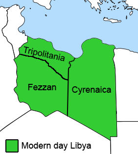
English: The Ottoman Turks conquered the country in the mid-16th century, and the three States or "Wilayat" of Tripolitania, Cyrenaica and Fezzan (which make up Libya) remained part of their empire with the exception of the virtual autonomy of the Karamanlis. The Karamanlis ruled from 1711 until 1835 mainly in Tripolitania, but had influence in Cyrenaica and Fezzan as well by the mid 18th century. |
|||
| Päiväys | ||||
| Lähde | self-made but based on this image on this image and this image | |||
| Tekijä | Esemono; improved by Kirk (talk) | |||
| Käyttöoikeus (Tämän tiedoston uudelleenkäyttö) |
|
|||
| Muut versiot |
Tämän tiedoston johdannaisteoksia:
   |
Kuvatekstit
Lisää yhden rivin pituinen kuvaus tästä tiedostosta
Kohteet, joita tässä tiedostossa esitetään
esittää
Tiedoston historia
Päiväystä napsauttamalla näet, millainen tiedosto oli kyseisellä hetkellä.
| Päiväys | Pienoiskuva | Koko | Käyttäjä | Kommentti | |
|---|---|---|---|---|---|
| nykyinen | 24. elokuuta 2011 kello 15.53 | | 282 × 314 (22 KiB) | Kirk979 | See discussion |
| 11. huhtikuuta 2011 kello 23.46 |  | 300 × 350 (35 KiB) | ANGELUS | border | |
| 11. huhtikuuta 2011 kello 23.35 |  | 300 × 350 (39 KiB) | ANGELUS | improved | |
| 12. lokakuuta 2009 kello 20.35 |  | 282 × 314 (22 KiB) | Kirk979 | corrections | |
| 1. maaliskuuta 2009 kello 14.00 |  | 282 × 314 (29 KiB) | Kirk979 | corrections | |
| 17. huhtikuuta 2008 kello 16.43 |  | 282 × 314 (25 KiB) | Esemono | Category:Maps of Libya Category:Map images that should use vector graphics |
Tiedoston käyttö
Seuraavat 4 sivua käyttävät tätä tiedostoa:
Tiedoston järjestelmänlaajuinen käyttö
Seuraavat muut wikit käyttävät tätä tiedostoa:
- Käyttö kohteessa ar.wikipedia.org
- Käyttö kohteessa azb.wikipedia.org
- Käyttö kohteessa az.wikipedia.org
- Käyttö kohteessa be.wikipedia.org
- Käyttö kohteessa bg.wikipedia.org
- Käyttö kohteessa bs.wikipedia.org
- Käyttö kohteessa ca.wikipedia.org
- Käyttö kohteessa cs.wikipedia.org
- Käyttö kohteessa da.wikipedia.org
- Käyttö kohteessa el.wikipedia.org
- Käyttö kohteessa en.wikipedia.org
- Cyrenaica
- Districts of Libya
- Fezzan
- Tripolitania
- Governorates of Libya
- Subdivisions of Libya
- Provinces of Libya
- Postage stamps and postal history of Tripolitania
- Kingdom of Libya
- Postage stamps and postal history of Cyrenaica
- Postage stamps and postal history of Libya
- Postage stamps and postal history of Fezzan and Ghadames
- Template:Regions of Libya
- Category:Regions of Libya
- Revenue stamps of Libya
- Tripolitania (province of Libya)
- Cyrenaica province
- Fezzan province
- Käyttö kohteessa eo.wikipedia.org
Näytä lisää tämän tiedoston järjestelmänlaajuista käyttöä.
Metatieto
Tämä tiedosto sisältää esimerkiksi kuvanlukijan, digikameran tai kuvankäsittelyohjelman lisäämiä lisätietoja. Kaikki tiedot eivät enää välttämättä vastaa todellisuutta, jos kuvaa on muokattu sen alkuperäisen luonnin jälkeen.
| Viimeksi muokattu | 12. lokakuuta 2009 kello 17.34 |
|---|---|
| Kuvan resoluutio leveyssuunnassa | 28 dpc |
| Kuvan resoluutio korkeussuunnassa | 28 dpc |
Noudettu kohteesta ”https://fi.wikipedia.org/wiki/Tiedosto:Ottoman_Provinces_Of_Present_day_Libya.png”