Fichier:Alberta's_Cities.png
De Wikipedia, l'encyclopédie encyclopedia
Taille de cet aperçu : 355 × 600 pixels. Autres résolutions : 142 × 240 pixels | 284 × 480 pixels | 454 × 768 pixels | 606 × 1 024 pixels | 1 741 × 2 941 pixels.
Fichier d’origine (1 741 × 2 941 pixels, taille du fichier : 298 kio, type MIME : image/png)
Ce fichier et sa description proviennent de Wikimedia Commons.
Description
| DescriptionAlberta's Cities.png |
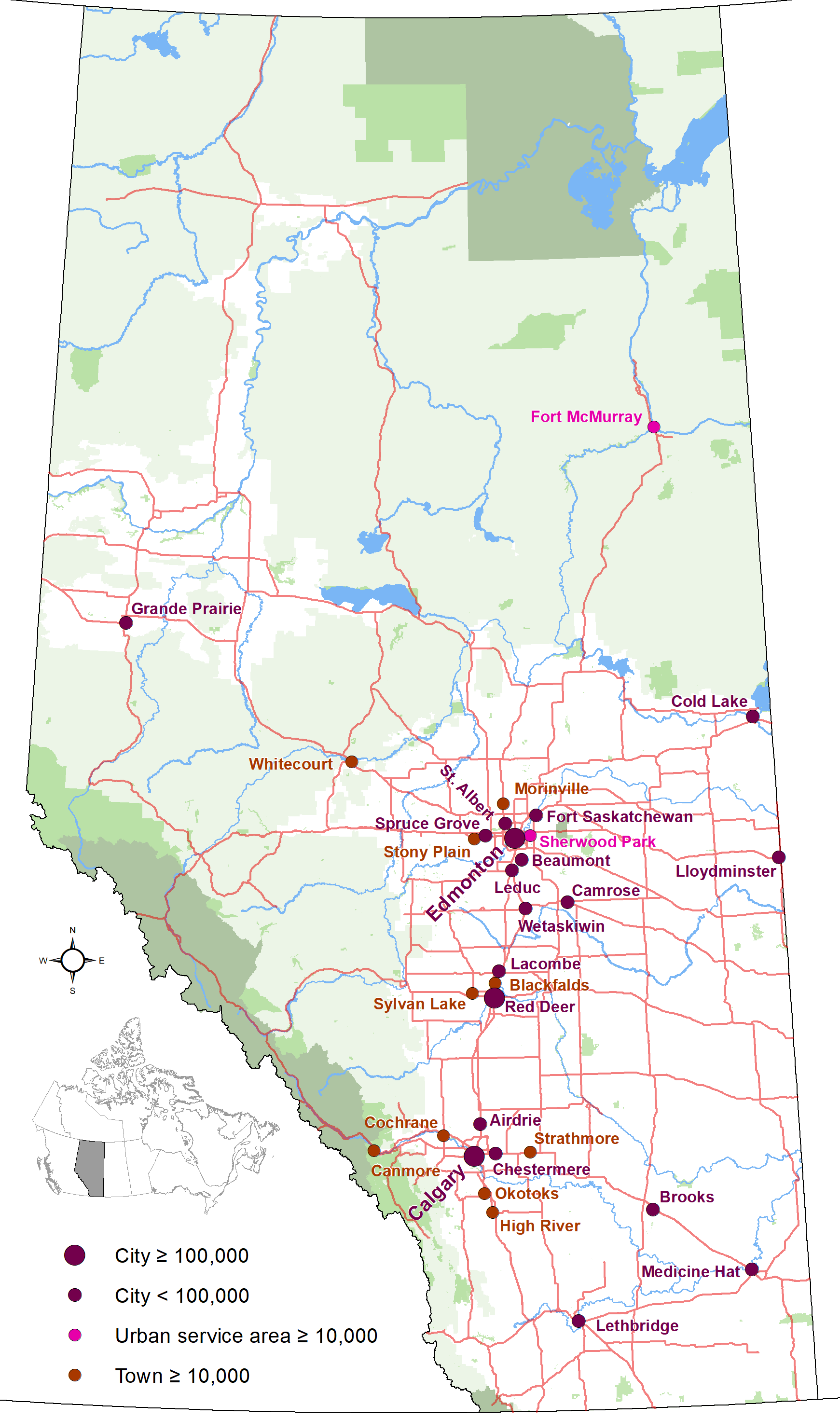
English: Map showing locations of Alberta 19 cities and city-equivalents (Fort McMurray and Sherwood Park urban service areas and towns with populations of 10,000 or greater) as of January 2019, with base reference features (major lakes and rivers, provincial 1-216 highway series, national parks, provincial protected areas and green and white areas). |
| Date | |
| Source | Travail personnel |
| Auteur | Hwy43 |
Conditions d’utilisation
Moi, en tant que détenteur des droits d’auteur sur cette œuvre, je la publie sous la licence suivante :
Ce fichier est disponible selon les termes de la licence Creative Commons Attribution 3.0 Non transposée.
- Vous êtes libre :
- de partager – de copier, distribuer et transmettre cette œuvre
- d’adapter – de modifier cette œuvre
- Sous les conditions suivantes :
- paternité – Vous devez donner les informations appropriées concernant l'auteur, fournir un lien vers la licence et indiquer si des modifications ont été faites. Vous pouvez faire cela par tout moyen raisonnable, mais en aucune façon suggérant que l’auteur vous soutient ou approuve l’utilisation que vous en faites.
Légendes
Ajoutez en une ligne la description de ce que représente ce fichier
Éléments décrits dans ce fichier
dépeint
Valeur sans élément de Wikidata
19 juillet 2013
image/png
56245efad0cd42d6cfa8e59162378a2ea6a51b43
305 255 octet
2 941 pixel
1 741 pixel
Historique du fichier
Cliquer sur une date et heure pour voir le fichier tel qu'il était à ce moment-là.
| Date et heure | Vignette | Dimensions | Utilisateur | Commentaire | |
|---|---|---|---|---|---|
| actuel | 25 octobre 2020 à 02:07 | | 1 741 × 2 941 (298 kio) | Hwy43 | Update to show Morinville is now eligible for city status with a population greater than 10,000. |
| 2 janvier 2019 à 08:49 |  | 1 741 × 2 941 (280 kio) | Hwy43 | uploading again (accidentally uploaded an updated towns map instead) | |
| 2 janvier 2019 à 08:46 |  | 1 741 × 2 941 (262 kio) | Hwy43 | Update to reflect Beaumont's change to city status and the Town of Blackfalds surpassing the city status minimum population threshold in its 2018 municipal census | |
| 27 décembre 2014 à 11:08 |  | 2 321 × 3 921 (392 kio) | Hwy43 | updated to reflect Chestermere's change from town status to city status effective January 1, 2015 | |
| 19 juillet 2013 à 08:07 |  | 1 741 × 2 941 (277 kio) | Hwy43 | User created page with UploadWizard |
Utilisation du fichier
Les 2 pages suivantes utilisent ce fichier :
Usage global du fichier
Les autres wikis suivants utilisent ce fichier :
- Utilisation sur azb.wikipedia.org
- Utilisation sur en.wikipedia.org
- Utilisation sur is.wikipedia.org
- Utilisation sur zh.wikipedia.org
Métadonnées
Ce fichier contient des informations supplémentaires, probablement ajoutées par l'appareil photo numérique ou le numériseur utilisé pour le créer.
Si le fichier a été modifié depuis son état original, certains détails peuvent ne pas refléter entièrement l'image modifiée.
| Résolution horizontale | 118,11 pt/cm |
|---|---|
| Résolution verticale | 118,11 pt/cm |
Ce document provient de « https://fr.wikipedia.org/wiki/Fichier:Alberta%27s_Cities.png ».