File:East-Hem_476ad.jpg
From Wikipedia, the free encyclopedia
Eredeti fájl (3 240 × 1 903 képpont, fájlméret: 754 KB, MIME-típus: image/jpeg)
|
Ez a fájl a Wikimedia Commonsból származik. Az alább látható leírás az ottani dokumentációjának másolata. A Commons projekt szabad licencű kép- és multimédiatár. Segíts te is az építésében! |

|
Ezt a képet el kellene készíteni vektorgrafika használatával SVG fájlként. A formátumnak számos előnye van; lásd a Commons:Media for cleanup lapot a további információkért. Ha a képnek már elérhető SVG-formátumú változata, töltsd fel. Az SVG feltöltése után cseréld le ezt a sablont a következőre: {{vector version available|új kép neve.svg}}.
|
 | Ez a kép (vagy az összes kép a lapon, vagy a kategóriában) JPEG formátumban lett feltöltve, pedig olyan részeket tartalmaz, amit hatékonyabban vagy pontosabban lehetne PNG vagy SVG formátumban tárolni. Ha lehetséges, töltsd fel a képet PNG vagy SVG formátumúra konvertálva, tömörítési hibák nélkül. Ehhez használj nem-JPEG forrást, vagy távolítsd el a tömörítési hibákat. |  |
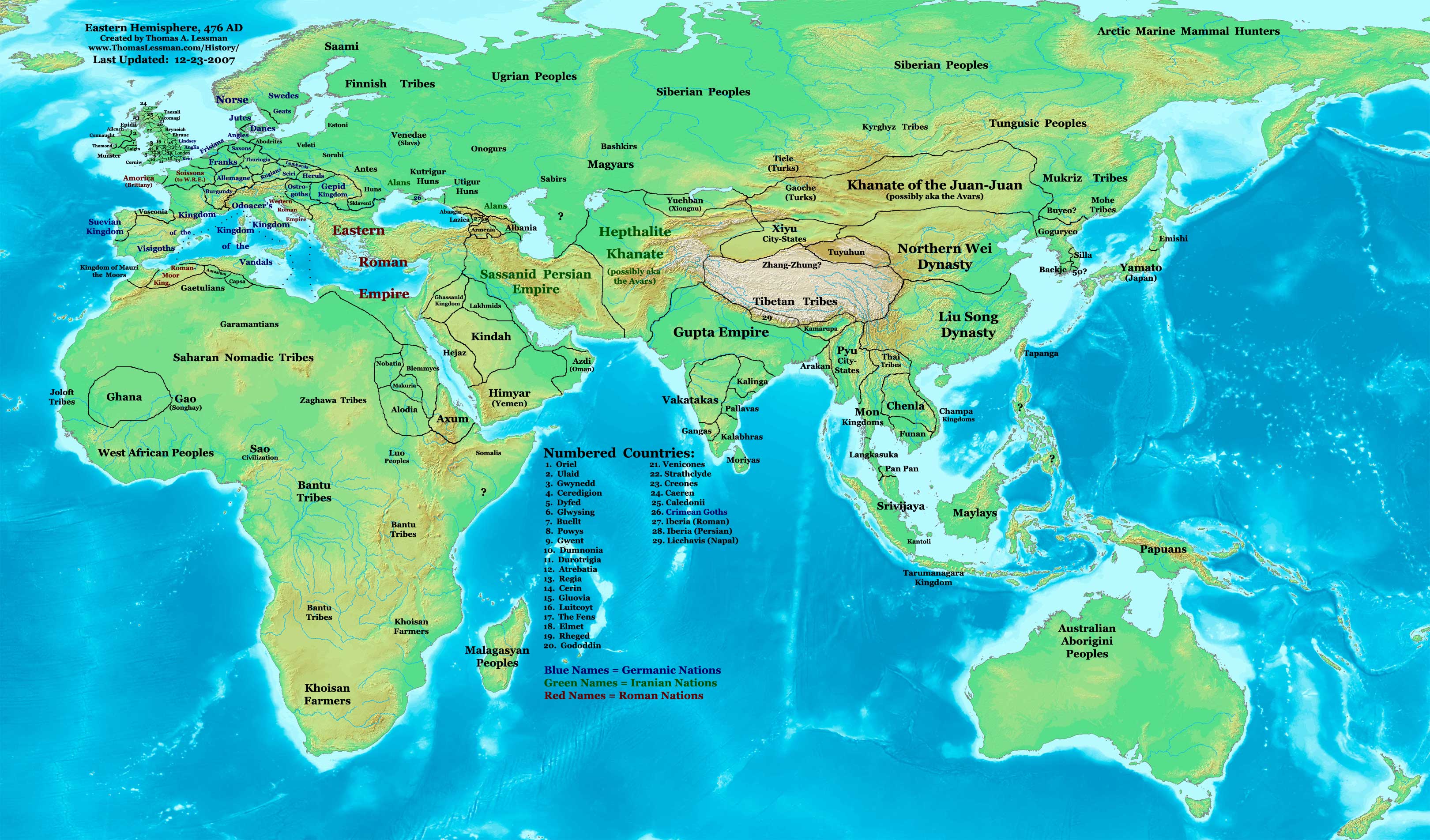
| LeírásEast-Hem 476ad.jpg | Eastern Hemisphere in 476 AD. | |||
| Forrás | self-made (For reference information, see the Map Source References section below.) | |||
| Szerző | Thomas Lessman (Contact!) | |||
| Engedély (Fájl újrafelhasználása) |
Én, e mű szerzője a művemet az alábbi licenc alatt teszem közzé: Ez a fájl a Creative Commons Nevezd meg! – Így add tovább! 3.0 Unported licenc alapján használható fel.
|
|||
| Más változatok |
|
.jpg)
Tartalomjegyzék
Map Summary
Original Source URL: http://www.thomaslessman.com/History/images/East-Hem_476ad.jpg.
This map of the Eastern Hemisphere in 476 AD was created by Thomas Lessman, based on information from the sources listed below. This map is free for educational use (see Permission info above). When using this map, please mention that it is available for free at www.WorldHistoryMaps.info.
Map Source References
- Remember, sources often conflict with each other. This map is only as accurate as the information that is available to me. To report any errors or to help further this work, please click here, or email Thomas Lessman at talessman@yis.us
References for information contained in this map:
1. The DK Atlas of World History, 2000 Edition; map of The World in 500 CE, (Pages 50-51) was used for information on several borders in this map.
2. Borders of Europe are mostly derived from the Euratlas.com map of Europe in 500 AD.
- a - Borders of Britain are derived from the "EarlyBritishKingdoms.com", map of map Britain in 475 AD.
3. Borders of Asia are derived mostly from the following sources:
- a - various Wikipedia articles and Google history map searches.
- (More info will be added soon)
4. Some information is derived from Wikimedia's map of The world in 500 CE, created by User:Javierfv1212.
5. Much of the information in this map was cross-checked with Bruce Gordon's Regnal Chronologies.
Other Historical Maps by Thomas Lessman
| Maps of the eastern hemisphere showing history
Bold dates are available on Wikimedia or Wikipedia. | ||
| Primeval | ||
| Ancient
|
·| 600 BC | 550 BC | 527 BC | 500 BC |
400 BC | ·| 1 AD | 50 AD | 100 AD | 200 AD | 300 AD | | |
| Medieval |
·| 500 AD | 565 AD | 600 AD | 700 AD | | |
| Modern |
·| 1500 AD | · * For historical maps of the whole world, | |
| history links talk edit view | ||
Eredeti feltöltési napló
- 2007-12-23 11:36 Talessman 3240×1903×8 (771644 bytes) Added numbered legend. Added more info for Manchuria, central Asia, Indonesia, Africa, and British Isles.
- 2007-11-06 22:07 Talessman 3240×1903×8 (718060 bytes) Updated borders for Sudan and Arabia.
- 2007-10-30 00:25 Talessman 3240×1903×8 (718905 bytes) Updated info on far eastern islands, Japan, Indonesia, etc.
- 2007-09-26 15:42 Talessman 2880×1692×8 (572882 bytes) Author: Thomas A. Lessman. Source URL: http://www.ThomasLessman.com/History/images/East-Hem_476ad.jpg. Image was created by me (Thomas Lessman) based on historical information located on Wikipedia, as well as information from maps located in Wikipedia and
- 2007-09-12 21:08 Talessman 2942×1728×8 (578540 bytes) Reverted to version as of 20:43, 12 September 2007
- 2007-09-12 20:44 Talessman 2942×1728×8 (578540 bytes) Reverted to version as of 19:32, 12 September 2007
- 2007-09-12 20:43 Talessman 2942×1728×8 (578540 bytes) Author: Thomas A. Lessman. Source URL: http://www.ThomasLessman.com/History/images/East-Hem_476ad.jpg. Image was created by me (Thomas Lessman) based on historical information located on Wikipedia, as well as information from maps located in Wikipedia and
- 2007-09-12 19:32 Talessman 2942×1728×8 (578540 bytes) Author: Thomas A. Lessman. Source URL: http://www.ThomasLessman.com/History/images/East-Hem_476ad.jpg. Image was created by me (Thomas Lessman) based on historical information located on Wikipedia, as well as information from maps located in Wikipedia and
- 2007-08-23 19:15 Talessman 1973×1159×8 (2352602 bytes) Reverted to earlier revision
- 2007-08-23 19:15 Talessman 1973×1159×8 (2373060 bytes) Author: Thomas A. Lessman. Source URL: http://www.ThomasLessman.com/History/images/East-Hem_600ad.jpg. Image was created by me (Thomas Lessman) based on historical information located on Wikipedia, as well as information from maps located in Wikipedia and
- 2007-08-23 19:12 Talessman 1973×1159×8 (2373060 bytes) Author: Thomas A. Lessman. Source URL: http://www.ThomasLessman.com/History/images/East-Hem_600ad.jpg. Image was created by me (Thomas Lessman) based on historical information located on Wikipedia, as well as information from maps located in Wikipedia and
- 2007-07-21 20:15 Talessman 1973×1159×8 (2352602 bytes) Author: Thomas A. Lessman. Source URL: http://www.ThomasLessman.com/History/images/East-Hem_476ad.jpg. Image was created by me (Thomas Lessman) based on historical information located on Wikipedia, as well as information from maps located in Wikipedia and
Képaláírások
A fájl által ábrázolt elemek
mű tárgya
Fájltörténet
Kattints egy időpontra, hogy a fájl akkori állapotát láthasd.
| Dátum/idő | Bélyegkép | Felbontás | Feltöltő | Megjegyzés | |
|---|---|---|---|---|---|
| aktuális | 2008. április 18., 16:32 | | 3 240 × 1 903 (754 KB) | Rottweiler | {{Information |Description=== Summary == Author: Thomas A. Lessman. Source URL: http://www.ThomasLessman.com/History/images/East-Hem_476ad.jpg. Image was created by Thomas Lessman based on historical information located in sources listed below. This map i |
Fájlhasználat
Ezt a fájlt nem használja egyetlen lap sem.
Globális fájlhasználat
A következő wikik használják ezt a fájlt:
- Használata itt: de.wikipedia.org
- Használata itt: en.wikipedia.org
- Használata itt: id.wikipedia.org
- Használata itt: jv.wikipedia.org
- Használata itt: rue.wikipedia.org
- Használata itt: ru.wikipedia.org
- Használata itt: sv.wikipedia.org
Metaadatok
Ez a kép járulékos adatokat tartalmaz, amelyek feltehetően a kép létrehozásához használt digitális fényképezőgép vagy lapolvasó beállításairól adnak tájékoztatást. Ha a képet az eredetihez képest módosították, ezen adatok eltérhetnek a kép tényleges jellemzőitől.
| _error | 0 |
|---|