File:Landlocked_countries.png
From Wikipedia, the free encyclopedia
Նախադիտման չափ՝ 800 × 351 պիքսել։ Այլ թույլտվությաններ: 320 × 140 պիքսել | 640 × 281 պիքսել | 1425 × 625 պիքսել.
Սկզբնական նիշք (1425 × 625 փիքսել, նիշքի չափը՝ 54 ԿԲ, MIME-տեսակը՝ image/png)
Այս նիշքը տեղադրված է Վիքիպահեստում է և այն կարող է օգտագործվել այլ նախագծերի կողմից։ Վիքիպահեստում նիշքի մասին տեղեկությունների հիմնական մասը ներկայացված է ստորև։


Բովանդակություն
Ամփոփում
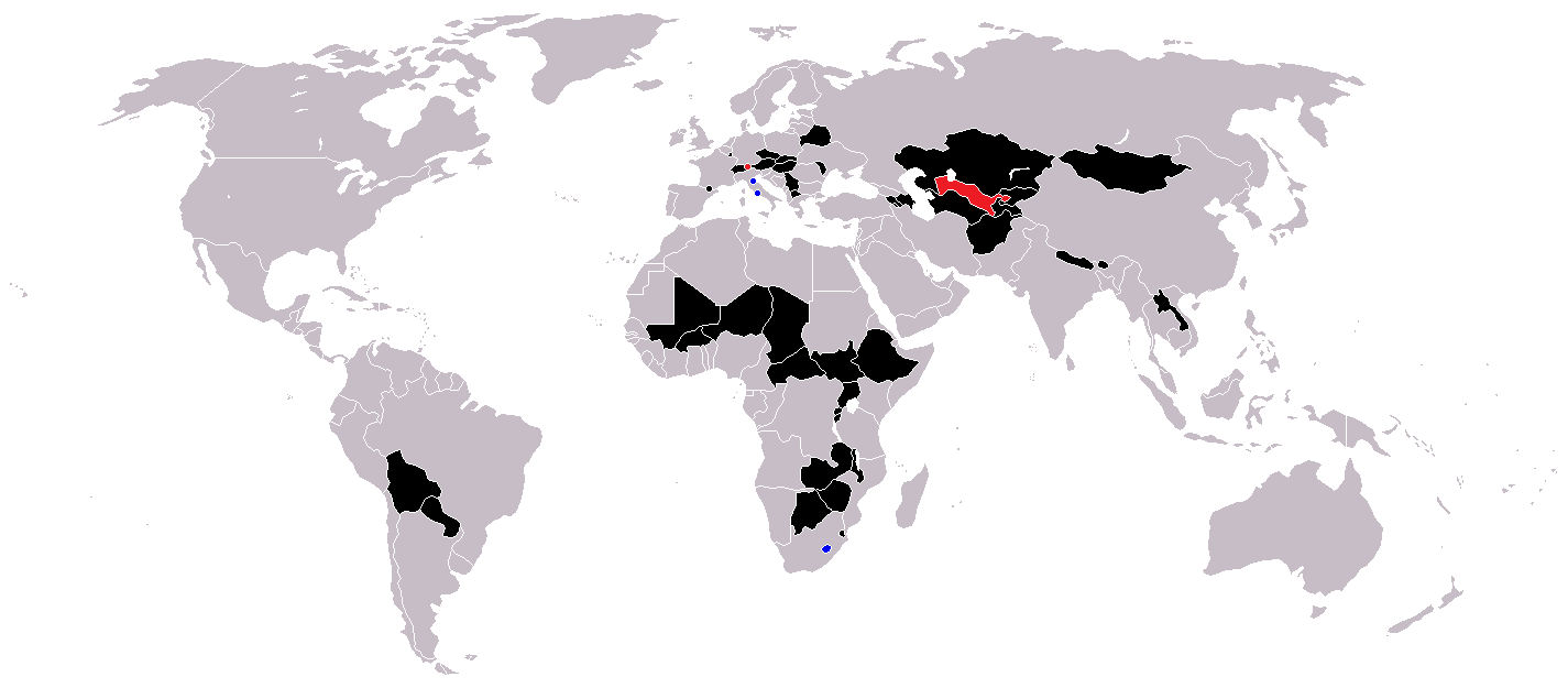
| ՆկարագրումLandlocked countries.png | |
| Թվական | |
| Աղբյուր | Բեռնողի սեփական աշխատանք |
| Հեղինակ | Ævar Arnfjörð Bjarmason |
Countries coloured black on the map
Countries coloured red on the map (double landlocked)
Countries coloured blue on the map (landlocked by a single country)
Արտոնագրում
| Public domainPublic domainfalsefalse |
| I, the copyright holder of this work, release this work into the public domain. This applies worldwide. In some countries this may not be legally possible; if so: I grant anyone the right to use this work for any purpose, without any conditions, unless such conditions are required by law. |
Captions
Add a one-line explanation of what this file represents
Landlocked countries
Pays sans littoral
Estados sin litoral
Stati senza sbocco al mare
Binnenstaaten der Welt
Sisämaavaltiot
Paese ca nun s'affaccene a 'o mare
Binnenstaat
Nações sem saída marítima
Items portrayed in this file
պատկերված
21 Հունիսի 2005
image/png
Նիշքի պատմություն
Մատնահարեք օրվան/ժամին՝ նիշքի այդ պահին տեսքը դիտելու համար։
| Օր/Ժամ | Մանրապատկեր | Օբյեկտի չափը | Մասնակից | Մեկնաբանություն | |
|---|---|---|---|---|---|
| ընթացիկ | 12:36, 1 Հունիսի 2018 | | 1425 × 625 (54 ԿԲ) | LamBoet | Reverted to version as of 16:39, 15 July 2011 (UTC) - Restore blue color for countries that are landlocked by a single country |
| 21:34, 2 Ապրիլի 2018 |  | 1425 × 625 (37 ԿԲ) | Maphobbyist | Check | |
| 21:03, 2 Ապրիլի 2018 |  | 1425 × 625 (37 ԿԲ) | Maphobbyist | Black coloring for San Marino, Vatican and Lesotho. | |
| 16:39, 15 Հուլիսի 2011 |  | 1425 × 625 (54 ԿԲ) | Hoshie | added South Sudan and added circles foe European microsates | |
| 13:47, 27 Սեպտեմբերի 2010 |  | 1425 × 625 (48 ԿԲ) | (지금은) 소년시대 | + Landlocked by a single country | |
| 05:33, 23 Հոկտեմբերի 2008 |  | 1425 × 625 (48 ԿԲ) | IngSoc BigBrother | ||
| 16:14, 25 փետրվարի 2007 |  | 1425 × 625 (30 ԿԲ) | Aivazovsky~commonswiki | ||
| 09:29, 23 Մայիսի 2006 |  | 1357 × 628 (46 ԿԲ) | Stefan040780 | source: same as old map, updated on 23.5.06 by stefan040780 | |
| 03:08, 21 Հունիսի 2005 |  | 1357 × 628 (25 ԿԲ) | Ævar Arnfjörð Bjarmason | Landlocked countries, based on Image:BlankMap-World.png. Category:World maps |
Նիշքի օգտագործում
Այս նիշքին օգտագործող էջեր չկան։
Նիշքի համընդհանուր օգտագործում
Հետևյալ այլ վիքիները օգտագործում են այս նիշքը՝
- Օգտագործումը ckb.wikipedia.org կայքում
- Օգտագործումը da.wikipedia.org կայքում
- Օգտագործումը eu.wikipedia.org կայքում
- Օգտագործումը fa.wikipedia.org կայքում
- Օգտագործումը fo.wikipedia.org կայքում
- Օգտագործումը fr.wikipedia.org կայքում
- Օգտագործումը hr.wikipedia.org կայքում
- Օգտագործումը hu.wikipedia.org կայքում
- Օգտագործումը is.wiktionary.org կայքում
- Օգտագործումը ja.wikipedia.org կայքում
- Օգտագործումը ja.wiktionary.org կայքում
- Օգտագործումը kk.wikipedia.org կայքում
- Օգտագործումը ko.wikipedia.org կայքում
- Օգտագործումը mk.wikipedia.org կայքում
- Օգտագործումը ms.wikipedia.org կայքում
- Օգտագործումը nso.wikipedia.org կայքում
- Օգտագործումը te.wikipedia.org կայքում
- Օգտագործումը uk.wikipedia.org կայքում
- Օգտագործումը vi.wikipedia.org կայքում
- Օգտագործումը zh-yue.wikipedia.org կայքում
Մետատվյալներ
Նիշքը պարունակում է ընդարձակ տվյալները, հավանաբար ավելացված թվային լուսանկարչական ապարատի կամ սկաների կողմից, որոնք օգտագործվել են նկարը ստեղծելու կամ թվայնացնելու համար։
Եթե նիշքը ձևափոխվել է ստեղծումից ի վեր, ապա որոշ տվյալները կարող են չհամապատասխանել ձևափոխված նիշքին։
| Horizontal resolution | 37,8 dpc |
|---|---|
| Vertical resolution | 37,8 dpc |
Ստացված է «https://hy.wikipedia.org/wiki/Պատկեր:Landlocked_countries.png» էջից