File:Map_administrative_divisions_of_the_First_French_Empire_1812-en.svg
From Wikipedia, the free encyclopedia

Սկզբնական նիշք (SVG-նիշք, անվանապես 2052 × 1728 փիքսել, նիշքի չափը՝ 3,86 ՄԲ)
Այս նիշքը տեղադրված է Վիքիպահեստում է և այն կարող է օգտագործվել այլ նախագծերի կողմից։ Վիքիպահեստում նիշքի մասին տեղեկությունների հիմնական մասը ներկայացված է ստորև։
Ամփոփում
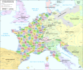
| ՆկարագրումMap administrative divisions of the First French Empire 1812-en.svg |
Català: Divisions administratives del Primer Imperi Francès el 1812
English: Administrative divisions of the First French Empire in 1812 |
| Թվական | |
| Աղբյուր |
|
| Հեղինակ | Andrein |
| Այլ մեկնակերպներ |
Other related versions:[խմբագրել]
|


Այս SVG ֆայլ օգտագործում է զետեղված տեքստ, որը կարելի է հեշտ թարգմանել ձեր լեզվի վրա using [toolforge:svgtranslate/File:Map_administrative_divisions_of_the_First_French_Empire_1812-en.svglink this automated tool]: Իմացեք ավելին: You can also download it and translate it manually using a text editor. |
This file is translated using SVG For most Wikipedia projects, you can embed the file normally (without a To translate the text into your language, you can use the SVG Translate tool. Alternatively, you can download the file to your computer, add your translations using whatever software you're familiar with, and re-upload it with the same name. You will find help in Graphics Lab if you're not sure how to do this. |
Արտոնագրում
- Դուք ազատ եք՝
- կիսվել ստեղծագործությամբ – պատճենել, տարածել և փոխանցել այս աշխատանքը։
- վերափոխել – ադապտացնել աշխատանքը
- Պահպանելով հետևյալ պայմանները'
- հղում – Դուք պետք է նշեք հեղինակի (իրավատիրոջ) հղումը:
- համանման տարածում – Եթե դուք ձևափոխում եք, փոխակերպում, կամ այս աշխատանքի հիման վրա ստեղծում եք նոր աշխատանք, ապա ձեր ստեղծածը կարող է տարածվել միայն նույն կամ համարժեք թույլատրագրով։
Captions
Items portrayed in this file
պատկերված
19 Հուլիսի 2015
image/svg+xml
Նիշքի պատմություն
Մատնահարեք օրվան/ժամին՝ նիշքի այդ պահին տեսքը դիտելու համար։
| Օր/Ժամ | Մանրապատկեր | Օբյեկտի չափը | Մասնակից | Մեկնաբանություն | |
|---|---|---|---|---|---|
| ընթացիկ | 12:33, 9 փետրվարի 2024 | | 2052 × 1728 (3,86 ՄԲ) | Manlleus | added catalan language |
| 17:10, 21 Մայիսի 2021 |  | 2052 × 1728 (3,55 ՄԲ) | Andrei Stroe | File uploaded using svgtranslate tool (https://svgtranslate.toolforge.org/). Added translation for ro. | |
| 12:32, 30 Օգոստոսի 2020 |  | 2052 × 1728 (3,24 ՄԲ) | Jfblanc | File uploaded using svgtranslate tool (https://svgtranslate.toolforge.org/). Added translation for oc. | |
| 10:37, 1 Մարտի 2018 |  | 2052 × 1728 (2,83 ՄԲ) | Imperator Honorius | Formatting Fix | |
| 10:29, 1 Մարտի 2018 |  | 2052 × 1728 (2,83 ՄԲ) | Imperator Honorius | Formatting and missing Anglicization (Gand to Ghent) | |
| 10:17, 1 Մարտի 2018 |  | 2052 × 1728 (2,83 ՄԲ) | Imperator Honorius | Spelling and typos; more Anglicised (and up to date) city names. | |
| 19:41, 20 Հուլիսի 2015 |  | 2052 × 1728 (2,82 ՄԲ) | ArdadN | spelling | |
| 17:11, 20 Հուլիսի 2015 |  | 2052 × 1728 (2,81 ՄԲ) | ArdadN | 1 | |
| 17:05, 20 Հուլիսի 2015 |  | 2052 × 1728 (2,81 ՄԲ) | ArdadN | font size | |
| 16:06, 20 Հուլիսի 2015 |  | 2052 × 1728 (2,81 ՄԲ) | ArdadN | 1 |
Նիշքի օգտագործում
Այս նիշքին օգտագործող էջեր չկան։
Նիշքի համընդհանուր օգտագործում
Հետևյալ այլ վիքիները օգտագործում են այս նիշքը՝
- Օգտագործումը af.wikipedia.org կայքում
- Օգտագործումը ar.wikipedia.org կայքում
- Օգտագործումը ca.wikipedia.org կայքում
- Օգտագործումը en.wikipedia.org կայքում
- History of the Netherlands
- 1810s
- Departments of France
- 130 departments of the First French Empire
- Illyrian Provinces
- Kingdom of Italy (Napoleonic)
- Portal:Maps/Maps/Political
- Portal:Maps/Maps/Political/14
- First French Empire
- Bouches-del'Èbre
- Department of Segre
- Left Bank of the Rhine
- User:Dakaysaa/sandbox
- User:Falcaorib/France
- Օգտագործումը et.wikipedia.org կայքում
- Օգտագործումը fr.wikipedia.org կայքում
- Օգտագործումը hr.wikipedia.org կայքում
- Օգտագործումը it.wikipedia.org կայքում
- Օգտագործումը ka.wikipedia.org կայքում
- Օգտագործումը km.wikipedia.org կայքում
- Օգտագործումը no.wikipedia.org կայքում
- Օգտագործումը pl.wikipedia.org կայքում
- Օգտագործումը pnb.wikipedia.org կայքում
- Օգտագործումը pt.wikipedia.org կայքում
- Օգտագործումը ru.wikipedia.org կայքում
- Օգտագործումը tr.wikipedia.org կայքում
- Օգտագործումը ur.wikipedia.org կայքում
- Օգտագործումը vi.wikipedia.org կայքում
Մետատվյալներ
Նիշքը պարունակում է ընդարձակ տվյալները, հավանաբար ավելացված թվային լուսանկարչական ապարատի կամ սկաների կողմից, որոնք օգտագործվել են նկարը ստեղծելու կամ թվայնացնելու համար։
Եթե նիշքը ձևափոխվել է ստեղծումից ի վեր, ապա որոշ տվյալները կարող են չհամապատասխանել ձևափոխված նիշքին։
| Width | 2051.7188 |
|---|---|
| Height | 1727.8906 |