Papeles:Gulf_of_Tonkin_location.gif
From Wikipedia, the free encyclopedia
Awan ti mabalin a nangatngato a resolusion.
Gulf_of_Tonkin_location.gif (500 × 500 dagiti piksel, kadakkel ti papeles: 90 KB, kita ti MIME: image/gif)
| Daytoy ket papeles a nagtaud manipud idiay Wikimedia Commons. Ti pakaammo manipud iti bukodna a deskripsion a panid idiay ket naiparang dita baba. Ti Commons ket repositorio dagiti nawaya a nalisensiaan a midia. Mabalinmo ti tumulong. |

|
This locator map image could be re-created using vector graphics as an SVG file. This has several advantages; see Commons:Media for cleanup for more information. If an SVG form of this image is available, please upload it and afterwards replace this template with
{{vector version available|new image name}}.
It is recommended to name the SVG file “Gulf of Tonkin location.svg”—then the template Vector version available (or Vva) does not need the new image name parameter. |
| DeskripsionGulf of Tonkin location.gif |
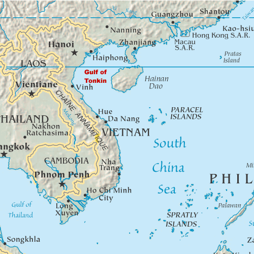
English: Map showing the location of the Gulf of Tonkin in the South China Sea |
|||
| Petsa | 31 Oktubre 2005 (original upload date) | |||
| Taudan | My original artwork based on a public domain map from the CIA World Factbook. | |||
| Mannurat | The original uploader was DanMS at English Wikipedia. | |||
| Pammalubos (Ti panagusar manen iti daytoy a papeles) |
|
Kasisigud a listaan pang-ipan
The original description page was here. All following user names refer to en.wikipedia.
- 2005-11-02 16:39 DanMS 500×500× (92188 bytes) Map showing the location of the Gulf of Tonkin in the South China Sea. My original artwork based on a public domain map from the CIA World Factbook. This is a modification of my earlier file by the same name. {{pd-user|DanMS}}
- 2005-10-31 21:55 DanMS 500×500× (89358 bytes) Map showing the location of the Gulf of Tonkin in the South China Sea. My original artwork based on a public domain map from the CIA World Factbook. {{pd-user|DanMS}}
Captions
Add a one-line explanation of what this file represents
خليج تونكين
Items portrayed in this file
mangipresenta
31 Oktubre 2005
Pakasaritaan ti papeles
Pinduten iti petsa/oras tapno makita ti papeles a kas naiparang iti dayta a panawen.
| Petsa/Oras | Bassit a ladawan | Dagiti rukod | Agar-aramat | Komentario | |
|---|---|---|---|---|---|
| agdama | 11:29, 15 Mayo 2010 | | 500 × 500 (90 KB) | Urdangaray | {{Information |Description={{en|Map showing the location of the Gulf of Tonkin in the South China Sea. My original artwork based on a public domain map from the CIA World Factbook.}} |Source=Transferred from [http://en.wikipedia.org en.wikipedia] |Date={{ |
Panagusar iti papeles
Ti sumaganad a panid ket agus-usar iti daytoy a papeles:
Global a panagusar ti papeles
Dagiti sumaganad a wiki ket agus-usar iti daytoy a papeles:
- Panagusar idiay af.wikipedia.org
- Panagusar idiay ar.wikipedia.org
- Panagusar idiay bg.wikipedia.org
- Panagusar idiay bn.wikipedia.org
- Panagusar idiay bs.wikipedia.org
- Panagusar idiay cs.wikipedia.org
- Panagusar idiay cy.wikipedia.org
- Panagusar idiay de.wikipedia.org
- Panagusar idiay en.wikipedia.org
- Panagusar idiay es.wikipedia.org
- Panagusar idiay fa.wikipedia.org
- Panagusar idiay fi.wikipedia.org
- Panagusar idiay fr.wikipedia.org
- Panagusar idiay fy.wikipedia.org
- Panagusar idiay he.wikipedia.org
- Panagusar idiay hi.wikipedia.org
- Panagusar idiay hu.wikipedia.org
- Panagusar idiay id.wikipedia.org
- Panagusar idiay it.wikipedia.org
- Panagusar idiay ja.wikipedia.org
- Panagusar idiay km.wikipedia.org
- Panagusar idiay ky.wikipedia.org
- Panagusar idiay mk.wikipedia.org
- Panagusar idiay nds-nl.wikipedia.org
- Panagusar idiay nl.wikipedia.org
- Panagusar idiay nn.wikipedia.org
- Panagusar idiay pl.wikipedia.org
- Panagusar idiay sh.wikipedia.org
- Panagusar idiay sl.wikipedia.org
- Panagusar idiay sr.wikipedia.org
- Panagusar idiay th.wikipedia.org
- Panagusar idiay ur.wikipedia.org
- Panagusar idiay vi.wikipedia.org
- Panagusar idiay war.wikipedia.org
- Panagusar idiay zh.wikipedia.org
Naala manipud iti "https://ilo.wikipedia.org/wiki/Papeles:Gulf_of_Tonkin_location.gif"