Plaetje:Naddniestrze.png
From Wikipedia, the free encyclopedia
Oearsprunkelik bestandj ((2.655 × 3.786 pixel, besjtandsgruutde: 5,13 MB, MIME type: image/png))
Dit besjtandj kump van Wikimedia Commons en kin ouch in anger projekte gebroek waere. De pagina mit de besjtandjsbesjrieving wurt hiejónger weergegaeve.
Besjrieving
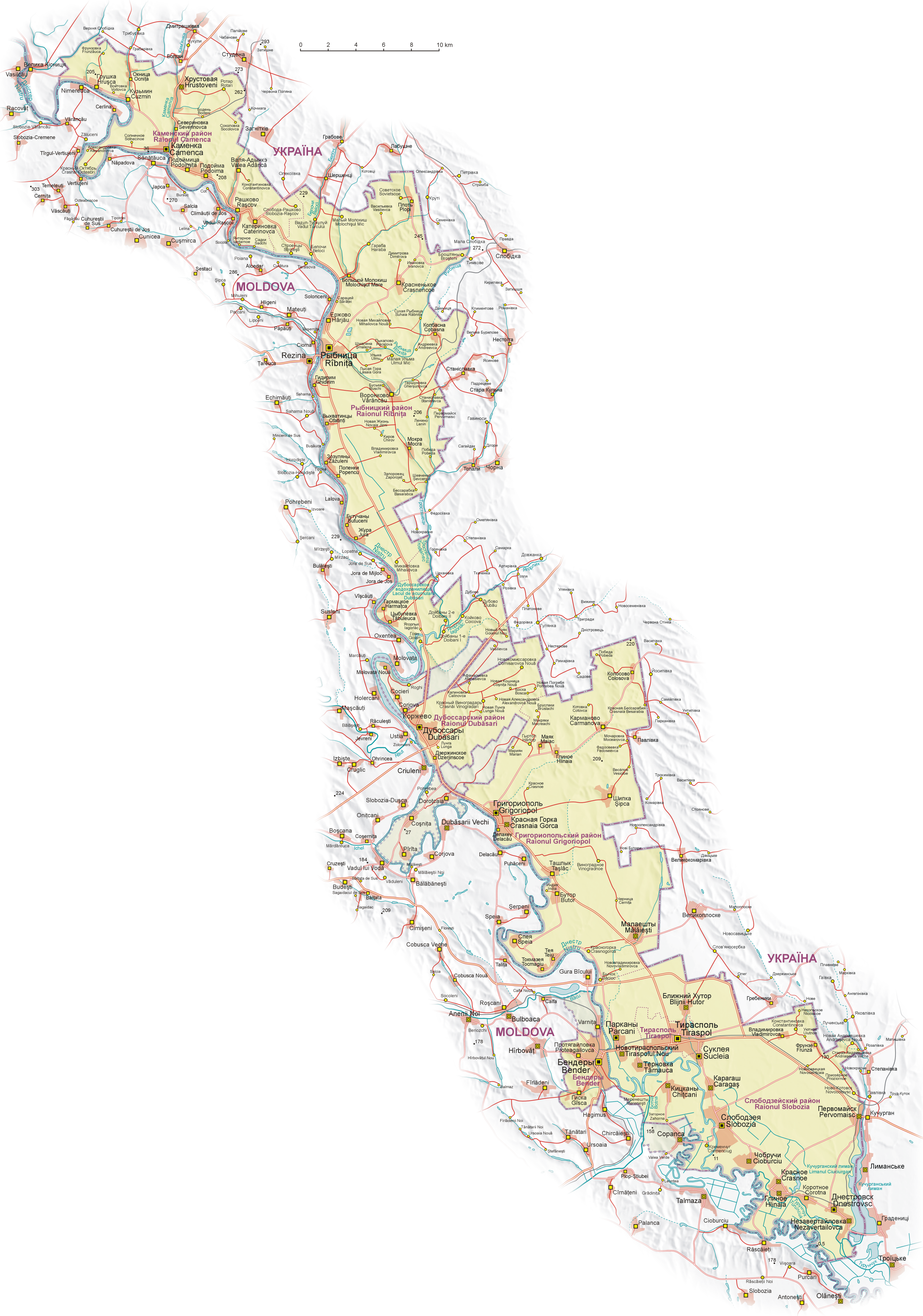
| BesjrievingNaddniestrze.png |
English: Map of Transnistria (with claimed area), based on Soviet and Ukrainian topographic map, and Shuttle Radar Topography Mission (STRM).
Geographical names:
 Polski: Mapa Naddniestrza (wraz z obszarem roszczeń). Mapa opracowana na podstawie radzieckich map topograficznych w skali 1:100 000 z końca lat 80. oraz ukraińskich map topograficznych z lat 2002-2006, rzeźba terenu wygenerowana na podstawie danych Shuttle Radar Topography Mission (STRM) udostępnionych przez United States Geological Survey.
Nazewnictwo geograficzne:
 Español: Mapa de Transnistria, basado en mapas topográficos soviéticos y ucranianos, y en la STRM. Nombres geográficos:
|
| Datum | |
| Brón | Eige werk |
| Sjriever | Aotearoa |
| Anger versies |
|


.png)


Licentie:

|
Toesteumming wert verleend veur t kopiëre, verspreide en/of wiezige van dit document onger de veurwaerd van de GNU-licentie veur vrieje documentatie, versie 1.2 of einige latere versie es gepubliceerd door de Free Software Foundation; zonger Invariant Sections, zonger Front-Cover Texts, en zonger Back-Cover Texts. n kopie van de licentie is opgenomme in de sectie GNU-licentie veur vrieje documentatie.http://www.gnu.org/copyleft/fdl.htmlGFDLGNU Free Documentation Licensetruetrue |
| Dit bestandj steit gelicenseerdj óngere Creative Commons Attribution-Share Alike 3.0 Unported lisensje. | ||
| ||
| Dees licentie-tag woort tougevoeg aon dit bestand in verband mèt de GFDL licentie-update.http://creativecommons.org/licenses/by-sa/3.0/CC BY-SA 3.0Creative Commons Attribution-Share Alike 3.0truetrue |
|
Deze afbeelding is beoordeeld aan de hand van de richtlijnen voor Kwaliteitsafbeeldingen en wordt beschouwd als een Kwaliteitsafbeelding.
العربية ∙ جازايرية ∙ беларуская ∙ беларуская (тарашкевіца) ∙ български ∙ বাংলা ∙ català ∙ čeština ∙ Cymraeg ∙ Deutsch ∙ Schweizer Hochdeutsch ∙ Zazaki ∙ Ελληνικά ∙ English ∙ Esperanto ∙ español ∙ eesti ∙ euskara ∙ فارسی ∙ suomi ∙ français ∙ galego ∙ עברית ∙ हिन्दी ∙ hrvatski ∙ magyar ∙ հայերեն ∙ Bahasa Indonesia ∙ italiano ∙ 日本語 ∙ Jawa ∙ ქართული ∙ 한국어 ∙ kurdî ∙ Lëtzebuergesch ∙ lietuvių ∙ македонски ∙ മലയാളം ∙ मराठी ∙ Bahasa Melayu ∙ Nederlands ∙ Norfuk / Pitkern ∙ polski ∙ português ∙ português do Brasil ∙ rumantsch ∙ română ∙ русский ∙ sicilianu ∙ slovenčina ∙ slovenščina ∙ shqip ∙ српски / srpski ∙ svenska ∙ தமிழ் ∙ తెలుగు ∙ ไทย ∙ Tagalog ∙ Türkçe ∙ toki pona ∙ українська ∙ vèneto ∙ Tiếng Việt ∙ 中文 ∙ 中文(简体) ∙ 中文(繁體) ∙ +/− |
Bijschriften
Items getoond in dit bestand
beeldt af Nederlands
maker Nederlands
Waarde zonder Wikidata-item
auteursrechtenstatus Nederlands
auteursrechtelijk beschermd Nederlands
datum van oprichting of creatie Nederlands
25 aug 2008
kwaliteitsbeoordeling op Commons Nederlands
kwaliteitsafbeelding op Wikimedia Commons Nederlands
bron van bestand Nederlands
originele creatie door uploader Nederlands
MIME-type Nederlands
image/png
Besjtandshistorie
Klik op 'ne datum/tied óm 't besjtand te zeen wie 't oetzaog op det tiedsjtip.
| Datum/Tied | Miniatuurplaetje | Aafmaetinge | Gebroeker | Kómmentaar | |
|---|---|---|---|---|---|
| hujig | 27 jul 2011 07:08 | | 2.655 × 3.786 (5,13 MB) | Nicolay Sidorov | + русское название села Коржево, исправил название села Zahorna - Загорное, а не "Захорна" |
| 14 sep 2008 12:18 |  | 2.655 × 3.786 (5,21 MB) | Aotearoa | {{Information |Description= |Source= |Date= |Author= |Permission= |other_versions= }} | |
| 25 aug 2008 22:01 |  | 2.655 × 3.790 (5,62 MB) | Aotearoa | {{Information |Description= |Source= |Date= |Author= |Permission= |other_versions= }} | |
| 25 aug 2008 21:39 |  | 2.962 × 4.230 (6,21 MB) | Aotearoa | {{Information |Description= |Source= |Date= |Author= |Permission= |other_versions= }} | |
| 25 aug 2008 21:27 |  | 3.054 × 4.271 (6,22 MB) | Aotearoa | {{Information |Description= |Source= |Date= |Author= |Permission= |other_versions= }} | |
| 25 aug 2008 20:51 |  | 3.054 × 4.271 (6,22 MB) | Aotearoa | {{Information |Description={{en|1=Map of Transnistria, based on Soviet and Ucrainian topographic map, and Shuttle Radar Topography Mission (STRM). Names in Transnistria according Transnistrian government}} {{pl|1= |
Plaetjesverwiezinge
Dit plaetje weurt op de volgende pazjena's gebroek:
Globaal besjtandjsgebroek
De volgende anger wiki's gebroeke dit bestandj:
- Gebroek in ast.wikipedia.org
- Gebroek in ca.wikipedia.org
- Gebroek in cs.wikipedia.org
- Gebroek in de.wikipedia.org
- Gebroek in en.wikipedia.org
- Gebroek in eo.wikipedia.org
- Gebroek in eu.wikipedia.org
- Gebroek in fr.wikipedia.org
- Gebroek in fr.wikinews.org
- Gebroek in gl.wikipedia.org
- Gebroek in he.wikipedia.org
- Gebroek in hu.wikipedia.org
- Gebroek in is.wikipedia.org
- Gebroek in ja.wikipedia.org
- Gebroek in ml.wikipedia.org
- Gebroek in nl.wikipedia.org
- Gebroek in pa.wikipedia.org
- Gebroek in pl.wikipedia.org
- Wikipedysta:Aotearoa/brudnopis
- Wikipedia:Ilustracje na Medal/rysunki i animacje
- Wikipedia:Propozycje do Ilustracji na Medal/Naddniestrze.png
- Dyskusja pliku:Naddniestrze.png
- Wikipedysta:Aotearoa/mapy
- Szablon:Ilustracja na medal/2011-09-02
- Szablon:Ilustracja na medal/2012-02-14
- Szablon:Ilustracja na medal/2013-02-10
- Szablon:Ilustracja na medal/2014-08-16
- Wikipedysta:The Polish/Nieużywane szablony/Ilustracja na medal/1-500
- Wikipedysta:The Polish/Nieużywane szablony/Ilustracja na medal/501-1000
- Wikipedysta:The Polish/Nieużywane szablony/Ilustracja na medal/1001-1500
- Gebroek in pt.wikipedia.org
- Gebroek in ro.wikipedia.org
- Gebroek in ru.wikipedia.org
- Gebroek in sd.wikipedia.org
- Gebroek in sr.wikipedia.org
Bekiek wikiwied gebroek van dit bestandj.