Bestand:1862_Johnson_Diagram_of_the_World_Time_Zones_from_Washington_-_Geographicus_-_Diagram-johnson-1862.jpg
Uit Wikipedia, de vrije encyclopedia
Grootte van deze voorvertoning: 511 × 599 pixels. Andere resoluties: 205 × 240 pixels | 409 × 480 pixels | 655 × 768 pixels | 873 × 1.024 pixels | 1.746 × 2.048 pixels | 2.984 × 3.500 pixels.
Oorspronkelijk bestand (2.984 × 3.500 pixels, bestandsgrootte: 2,2 MB, MIME-type: image/jpeg)
| Dit is een bestand van Wikimedia Commons. Onderstaande beschrijving komt van de beschrijving van het bestand daar. |
| Alvin Jewett Johnson: A Diagram Exhibiting the difference of time between the places shown & Washington.
( |
|||||||||||||||||||||||
|---|---|---|---|---|---|---|---|---|---|---|---|---|---|---|---|---|---|---|---|---|---|---|---|
| Kunstenaar |
artist QS:P170,Q18507750 |
||||||||||||||||||||||
| Titel |
A Diagram Exhibiting the difference of time between the places shown & Washington. |
||||||||||||||||||||||
| Beschrijving |
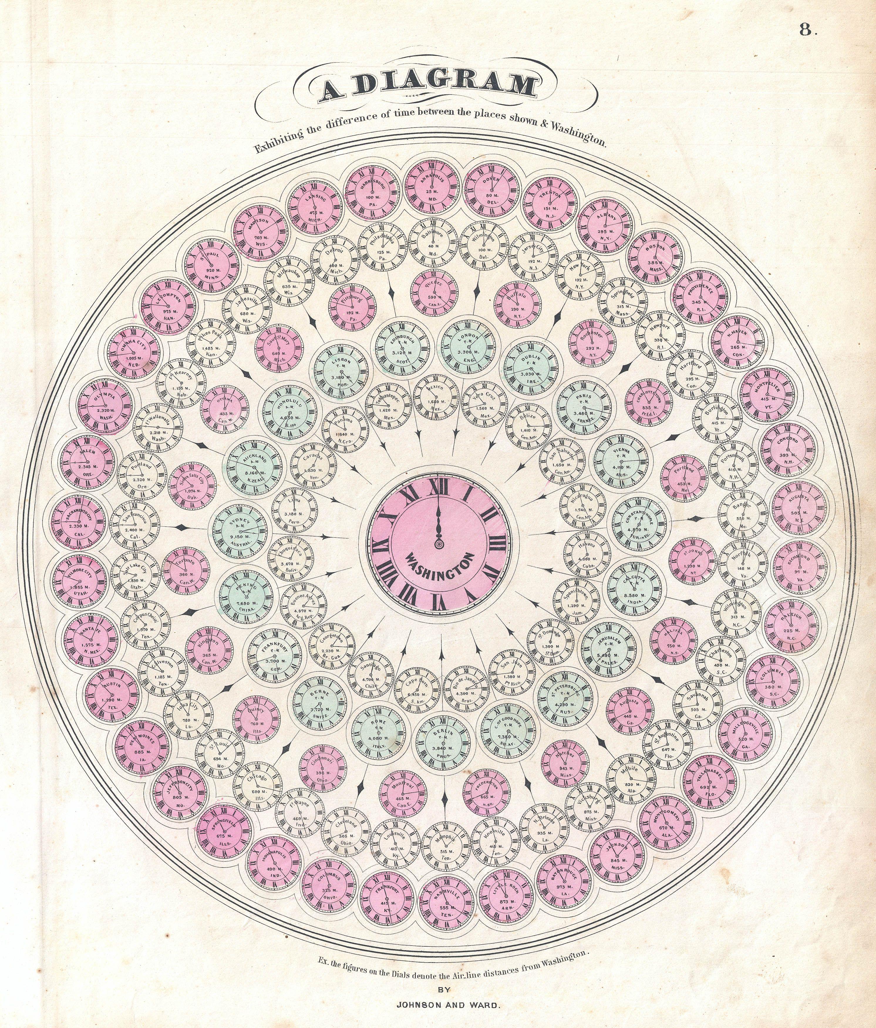
English: A very attractive example of Johnson's 1862 diagram of the world's time zones. Consists of a circular engraving in which numerous clocks are drawn, each representing a major world city. At the center is clock representing the time in Washington, D.C. The time in Washington is set at 12 and the remaining clock are adjusted accordingly So, if it is 12 in Washington, it is 11:02 in Calcutta and 6:35 in Honolulu, etc. Published by A. J. Johnson and Ward as plate number 8 in the 1862 edition of Johnson’s New Illustrated Family Atlas . This is the first edition of the Family Atlas to bear the Johnson and Ward imprint. |
||||||||||||||||||||||
| Datum | 1862 (undated) | ||||||||||||||||||||||
| Afmetingen |
hoogte: 16 in (40,6 cm); breedte: 13,5 in (34,2 cm) dimensions QS:P2048,16U218593 dimensions QS:P2049,13.5U218593 |
||||||||||||||||||||||
| Inventarisnummer |
Geographicus link: Diagram-johnson-1862 |
||||||||||||||||||||||
| Bron/fotograaf |
Johnson, A. J., Johnson's New Illustrated (Steel Plate) Family Atlas with Descriptions, Geographical, Statistical, and Historical. (1862 A. J. Johnson & Ward edition)
|
||||||||||||||||||||||
| Toestemming (Hergebruik van dit bestand) |
|
||||||||||||||||||||||
Bijschriften
Beschrijf in één regel wat dit bestand voorstelt
Items getoond in dit bestand
beeldt af
image/jpeg
265d8c508ecbeeae94c60348d0719f08e6973d55
2.301.627 byte
3.500 pixel
2.984 pixel
Bestandsgeschiedenis
Klik op een datum/tijd om het bestand te zien zoals het destijds was.
| Datum/tijd | Miniatuur | Afmetingen | Gebruiker | Opmerking | |
|---|---|---|---|---|---|
| huidige versie | 23 mrt 2011 02:47 | | 2.984 × 3.500 (2,2 MB) | BotMultichillT | {{subst:User:Multichill/Geographicus |link=http://www.geographicus.com/P/AntiqueMap/Diagram-johnson-1862 |product_name=1862 Johnson Diagram of the World Time Zones from Washington |map_title=A Diagram Exhibiting the difference of time between the places s |
Bestandsgebruik
Dit bestand wordt op de volgende pagina gebruikt:
Globaal bestandsgebruik
De volgende andere wiki's gebruiken dit bestand:
- Gebruikt op cs.wikipedia.org