Bestand:Habsburg_Map_1547.jpg
Uit Wikipedia, de vrije encyclopedia
Oorspronkelijk bestand (1.654 × 1.029 pixels, bestandsgrootte: 534 kB, MIME-type: image/jpeg)
| Dit is een bestand van Wikimedia Commons. Onderstaande beschrijving komt van de beschrijving van het bestand daar. |
Beschrijving
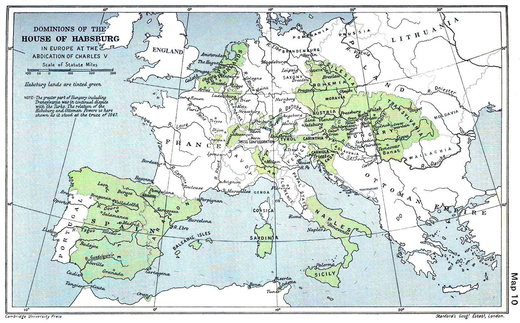
| BeschrijvingHabsburg Map 1547.jpg |
English: A map of the dominion of the Habsburgs following the Battle of Mühlberg (1547) |
| Datum | |
| Bron |
The Cambridge Modern History Atlas, edited by Sir Adolphus William Ward, G.W. Prothero, Sir Stanley Mordaunt Leathes, and E.A. Benians. Cambridge University Press: London, 1912. Editors were Sir Adolphus William Ward (†1924), G.W. Prothero (†1922), and Sir Stanley Mordaunt Leathes (†1938). Individual authors of works making up the atlas are not identified, nor are the likely to be, after reasonable research. |
| Auteur | edited by Sir Adolphus William Ward, G.W. Prothero, Sir Stanley Mordaunt Leathes |
| Andere versies |
|

Licentie
| Public domainPublic domainfalsefalse |
Dit werk bevindt zich in het publiek domein in de Verenigde Staten omdat het gepubliceerd werd (of geregistreerd bij de U.S. Copyright Office) voor 1 januari 1929.
Werken in het publiek domein moeten zowel vrij van auteursrechten zijn in de Verenigde Staten als in het land van herkomst van het werk om te worden gehost op Commons. Indien het werk geen Amerikaans werk is, moet het bestand een aanvullende copyright tag hebben met de auteursrechtelijke status in het land van herkomst.
|
| Public domainPublic domainfalsefalse |
This UK artistic or literary work, of which the author is unknown and cannot be ascertained by reasonable enquiry, is in the public domain because it is one of the following:
|
 |
Bijschriften
Items getoond in dit bestand
beeldt af
Bestandsgeschiedenis
Klik op een datum/tijd om het bestand te zien zoals het destijds was.
| Datum/tijd | Miniatuur | Afmetingen | Gebruiker | Opmerking | |
|---|---|---|---|---|---|
| huidige versie | 29 mrt 2018 11:20 | | 1.654 × 1.029 (534 kB) | Trecătorul răcit | Little add: borders of the time |
| 3 sep 2015 13:01 |  | 1.654 × 1.029 (518 kB) | Kurzon | Reverted to version as of 17:22, 9 August 2010 | |
| 3 sep 2015 13:01 |  | 1.654 × 1.029 (518 kB) | Kurzon | Reverted to version as of 17:22, 9 August 2010 | |
| 29 jun 2013 23:33 |  | 1.654 × 1.029 (546 kB) | CSvBibra | add more contrast per request by another user | |
| 9 aug 2010 19:22 |  | 1.654 × 1.029 (518 kB) | CSvBibra | Previously put cleaned up version in new file with "b" after name. Now updating original file with "b" version. Both files uses throughout Wikipedias | |
| 28 aug 2008 11:07 |  | 1.654 × 1.029 (649 kB) | F l a n k e r | Wrap, shadows and minor improvements | |
| 28 jun 2005 16:42 |  | 1.654 × 1.029 (421 kB) | Rythin~commonswiki | A map of the dominion of the Habsburgs following the Battle of Mühlberg (1547). Taken from ''The Cambridge Modern History Atlas,'' edited by Sir Adolphus William Ward, G.W. Prothero, Sir Stanley Mordaunt Leathes, and E.A. Benians. Cambridge University Pr |
Bestandsgebruik
Dit bestand wordt op de volgende 4 pagina's gebruikt:
Globaal bestandsgebruik
De volgende andere wiki's gebruiken dit bestand:
- Gebruikt op af.wikipedia.org
- Gebruikt op an.wikipedia.org
- Gebruikt op ar.wikipedia.org
- Gebruikt op arz.wikipedia.org
- Gebruikt op ast.wikipedia.org
- Gebruikt op azb.wikipedia.org
- Gebruikt op ba.wikipedia.org
- Gebruikt op be.wikipedia.org
- Gebruikt op bg.wikipedia.org
- Gebruikt op br.wikipedia.org
- Gebruikt op bs.wikipedia.org
- Gebruikt op ca.wikipedia.org
- Gebruikt op cs.wikipedia.org
- Gebruikt op da.wikipedia.org
- Gebruikt op de.wikipedia.org
- Gebruikt op el.wikipedia.org
Globaal gebruik van dit bestand bekijken.
Metadata
Dit bestand bevat metadata met EXIF-informatie, die door een fotocamera, scanner of fotobewerkingsprogramma toegevoegd kan zijn.
| Gebruikte software | Adobe Photoshop CS3 Macintosh |
|---|---|
| Oriëntatie | Normaal |
| Horizontale resolutie | 200 dpi |
| Verticale resolutie | 200 dpi |
| Tijdstip laatste bestandswijziging | 14 mrt 2018 17:05 |
| Kleurruimte | Ongekalibreerd |
| Afbeeldingsbreedte | 1.654 px |
| Afbeeldingshoogte | 1.029 px |
| Tijdstip digitalisering | 13 mrt 2018 15:53 |
| Datum waarop de metadata het laatst zijn bewerkt | 14 mrt 2018 18:05 |