Bestand:Map_of_Assyria.png
Uit Wikipedia, de vrije encyclopedia
Grootte van deze voorvertoning: 800 × 550 pixels. Andere resoluties: 320 × 220 pixels | 640 × 440 pixels | 1.024 × 704 pixels | 1.280 × 880 pixels | 1.983 × 1.363 pixels.
Oorspronkelijk bestand (1.983 × 1.363 pixels, bestandsgrootte: 160 kB, MIME-type: image/png)
| Dit is een bestand van Wikimedia Commons. Onderstaande beschrijving komt van de beschrijving van het bestand daar. |
| BeschrijvingMap of Assyria.png |
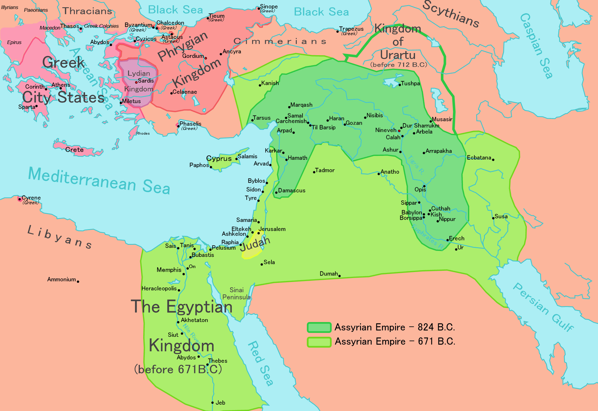
[bewerken] English: Map of the Assyrian Empire Español: Extensión del Imperio Asirio Polski: Mapa Asyrii w 824 i 671 r. p.n.e. Português: Extensão do Império Assírio العربية : خارطة الإمبراطوريَّة الآشوريَّة. فارسی : نقشه امپراتوری آشور |
|||||
| Datum | ||||||
| Bron |
Own work data from
|
|||||
| Auteur | Ningyou | |||||
| Toestemming (Hergebruik van dit bestand) |
|
|||||
| Andere versies |
[bewerken]
|


Bijschriften
Beschrijf in één regel wat dit bestand voorstelt
Map of the Assyrian Empire 824 BCE to 671 BCE
Мапа Ассирійської імперії
Items getoond in dit bestand
beeldt af
26 feb 2006
image/png
Bestandsgeschiedenis
Klik op een datum/tijd om het bestand te zien zoals het destijds was.
| Datum/tijd | Miniatuur | Afmetingen | Gebruiker | Opmerking | |
|---|---|---|---|---|---|
| huidige versie | 24 mei 2018 14:32 | | 1.983 × 1.363 (160 kB) | Capmo | corrected typos in Trapezus and Hamath |
| 12 sep 2010 20:33 |  | 1.983 × 1.363 (148 kB) | Ras67 | cropped and squeezed | |
| 1 sep 2010 02:35 |  | 1.985 × 1.365 (161 kB) | Capmo | typo in word "Aegean"; 256 colors | |
| 21 jan 2010 23:05 |  | 1.985 × 1.365 (645 kB) | Megistias | Border around map, Details | |
| 26 feb 2006 16:51 |  | 1.985 × 1.365 (640 kB) | Ningyou | This is a large map of Assyria, made by Ningyou. For translations of this map, contact Ningyou. Category:Assyria |
Bestandsgebruik
Dit bestand wordt op de volgende 7 pagina's gebruikt:
Globaal bestandsgebruik
De volgende andere wiki's gebruiken dit bestand:
- Gebruikt op af.wikipedia.org
- Gebruikt op als.wikipedia.org
- Gebruikt op am.wikipedia.org
- Gebruikt op an.wikipedia.org
- Gebruikt op arc.wikipedia.org
- Gebruikt op ar.wikipedia.org
- Gebruikt op ast.wikipedia.org
- Gebruikt op azb.wikipedia.org
- Gebruikt op az.wikipedia.org
- Gebruikt op ba.wikipedia.org
- Gebruikt op be.wikipedia.org
- Gebruikt op bg.wikipedia.org
- Gebruikt op bn.wikipedia.org
- Gebruikt op ckb.wikipedia.org
- Gebruikt op cs.wikipedia.org
- Gebruikt op cv.wikipedia.org
- Gebruikt op cy.wikipedia.org
- Gebruikt op dag.wikipedia.org
- Gebruikt op da.wikipedia.org
- Gebruikt op de.wikipedia.org
- Gebruikt op el.wikipedia.org
- Gebruikt op en.wikipedia.org
Globaal gebruik van dit bestand bekijken.
Metadata
Dit bestand bevat metadata met EXIF-informatie, die door een fotocamera, scanner of fotobewerkingsprogramma toegevoegd kan zijn.
| Horizontale resolutie | 37,8 dpc |
|---|---|
| Verticale resolutie | 37,8 dpc |
Overgenomen van "https://nl.wikipedia.org/wiki/Bestand:Map_of_Assyria.png"