File:Holy_Roman_Empire_1648.svg
Uit Wikipedia, de vrije encyclopedia

Oorspronkelijk bestand (SVG-bestand, nominaal 2.283 × 1.810 pixels, bestandsgrootte: 3,07 MB)
| Dit is een bestand van Wikimedia Commons. Onderstaande beschrijving komt van de beschrijving van het bestand daar. |
Beschrijving
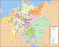
| BeschrijvingHoly Roman Empire 1648.svg |
English: Map of the Holy Roman Empire in 1648, after the Peace of Westphalia which ended the Thirty Years' War. Deutsch: Karte des Heiligen Römischen Reiches 1648, nach dem Westfälischer Friede, der den Dreißigjähriger Krieg beendete. Français : Carte du Saint-Empire à 1648, après la paix de Westphalie qui mettent fin à la guerre de Trente Ans. Version française est disponible à File:Holy Roman Empire 1648 fr.svg. Српски / srpski: Мапа Светог римског царства у 1648, након Вестфалског мира којим је завршен Тридесетогодишњи рат.
|
English | Deutsch | Français | Српски |
||
|---|---|---|---|---|---|
| A | Archbishopric | Erzbistum | Archevêché | АДИЈ. | Архидијецеза |
| B | Bishopric | Bistum | Évêché | ДИЈ. | Дијецеза |
| C | County | Grafschaft | Comté | ОКР./ГРОФ. | Округ/грофовија |
| D | Duchy | Herzogtum | Duché | ВОЈВ. | Војводство |
| E | Electorate | Kurfürstentum | Électorat | ЕЛЕКТ. | Електорат |
| L | Landgraviate | Landgrafschaft | Landgraviat | ЛГРОФ. | Ландгрофовија |
| M | Margraviate | Markgrafschaft | Margraviat | МГРОФ. | Маркгрофовија |
| P | Principality | Fürstentum | Principauté | ГРОФ./ОКР. | Грофовија/округ |
Legend / Farblegende / Légende / Легенда
English | Deutsch | Français | Српски |
|
|---|---|---|---|---|
Palatinat des Wittelsbach |
||||
Wittelsbach Bavaria |
Wittelsbacher Bayern |
Bavière des Wittelsbach |
Вителсбах, баварски | |
Hohenzollern Franconia |
Hohenzollerner Franken |
Хоенцолерн, франконски | ||
Wettin Ernestine Saxony |
Wettiner Ernestiner Sachsen |
Saxe de la branche ernestine des Wettin |
Ветин, ернестински | |
Made from the public domain map "Central Europe about 1648" from the Historical Atlas by William R. Shepherd, at the Perry-Castañeda Library Map Collection at the University of Texas. Further information from Overy, Richard, 2006, The Times Complete history of the world Times Books ISBN 0007181299, and from this map
See also other maps at external links:
- Central Europe 1648
- Map on personal site, Europe in 1648
- Treaty of Westphalia
- 1648 map of Prussia
- Britannica, Spanish domains in 1648
(Hergebruik van dit bestand)

|
Toestemming wordt verleend voor het kopiëren, verspreiden en/of wijzigen van dit document onder de voorwaarden van de GNU-licentie voor vrije documentatie, versie 1.2 of enige latere versie als gepubliceerd door de Free Software Foundation; zonder Invariant Sections, zonder Front-Cover Texts, en zonder Back-Cover Texts. Een kopie van de licentie is opgenomen in de sectie GNU-licentie voor vrije documentatie.http://www.gnu.org/copyleft/fdl.htmlGFDLGNU Free Documentation Licensetruetrue |
| Dit bestand is gelicenseerd onder de Creative Commons-licentie Naamsvermelding-Gelijk delen 3.0 Unported | ||
| ||
| Deze licentietag is toegevoegd aan dit bestand in verband met de GFDL licentie-update.http://creativecommons.org/licenses/by-sa/3.0/CC BY-SA 3.0Creative Commons Attribution-Share Alike 3.0truetrue |
[bewerken]
-
 Engels SVG
 -
 Spaans SVG
 -
 Frans SVG
 -
 Georgisch SVG
 -
 Servisch SVG
 -
 English: Blank PNG
 -
 Engels PNG
 -
 Spaans PNG
 -
 Servisch PNG
 -
 Russisch PNG


| Dit SVG-bestand maakt gebruik van geïntegreerde tekst die gemakkelijk kan worden vertaald naar uw taal met een SVG editor, een tekstverwerker of het hulpmiddel SVG Translate. Uitleg |
Bijschriften
Items getoond in dit bestand
beeldt af
Waarde zonder Wikidata-item
29 jan 2007
image/svg+xml
Bestandsgeschiedenis
Klik op een datum/tijd om het bestand te zien zoals het destijds was.
| Datum/tijd | Miniatuur | Afmetingen | Gebruiker | Opmerking | |
|---|---|---|---|---|---|
| huidige versie | 24 jul 2022 22:43 | | 2.283 × 1.810 (3,07 MB) | Maproom | ZWEIBRCKEN -> ZWEIBRÜCKEN, Treves -> Trier, Liege -> Liège |
| 18 mei 2022 19:55 |  | 2.283 × 1.810 (3,07 MB) | Maproom | Consistent, and German, spelling of "Mainz" | |
| 25 mei 2021 22:11 |  | 2.283 × 1.810 (3,07 MB) | ElCet | added the biggest city of Upper Silesia back then | |
| 23 mrt 2018 13:34 |  | 2.283 × 1.810 (3,01 MB) | Valentinian | Cleanup some names including missing umlauts. Brunswick-Lüneburg -> Brunswick-Celle (see talk). Border north of Rendsburg seems slightly off to me and the situation in Holstein is rather simplified (jointly administered areas are missing). | |
| 8 okt 2010 21:09 |  | 2.283 × 1.810 (3,01 MB) | Joostik | Ravenstein as part of Cleves | |
| 9 aug 2009 21:45 |  | 2.283 × 1.810 (3,01 MB) | Ysangkok | simplify code (save as plain svg) | |
| 14 jul 2009 11:24 |  | 2.283 × 1.810 (4,17 MB) | Roke~commonswiki | Zusmarshausen | |
| 20 apr 2007 17:16 |  | 2.283 × 1.810 (4,12 MB) | Roke~commonswiki | ||
| 20 apr 2007 04:04 |  | 2.283 × 1.810 (4,11 MB) | Roke~commonswiki | rm HRE text, darken labels | |
| 18 apr 2007 05:04 |  | 2.283 × 1.810 (4,11 MB) | Roke~commonswiki |
Bestandsgebruik
Geen enkele pagina gebruikt dit bestand.
Globaal bestandsgebruik
De volgende andere wiki's gebruiken dit bestand:
- Gebruikt op af.wikipedia.org
- Gebruikt op azb.wikipedia.org
- Gebruikt op az.wikipedia.org
- Gebruikt op br.wikipedia.org
- Gebruikt op ca.wikipedia.org
- Gebruikt op ckb.wikipedia.org
- Gebruikt op cs.wikipedia.org
- Gebruikt op el.wikipedia.org
- Gebruikt op en.wikipedia.org
- Peace of Westphalia
- Thirty Years' War
- Germans
- Wikipedia:WikiProject Maps
- Imperial Estate
- Talk:Paul Skalich
- Treaty of Fontainebleau (1631)
- Wikipedia:Featured picture candidates/Holy Roman Empire in 1648
- Wikipedia:Featured picture candidates/May-2007
- User talk:Giano II/archive 7
- User:Luosiji/Sandbox
- User:Jammydodger/HRE
- Germany in the early modern period
- User:Zealotzuo/Sandbox
- Wikipedia talk:WikiProject Maps/Archive 5
- Territorial evolution of France
- User:Oaholroyd/sandbox
- User:JMvanDijk/Sandbox 10
- User:DyinRich/Something Else
- Aftermath of the Eighty Years' War
- Gebruikt op eo.wikipedia.org
- Gebruikt op et.wikipedia.org
- Gebruikt op fa.wikipedia.org
- Gebruikt op fi.wikipedia.org
- Gebruikt op fy.wikipedia.org
- Gebruikt op hu.wikipedia.org
- Gebruikt op hy.wikipedia.org
- Gebruikt op id.wikipedia.org
- Gebruikt op it.wikipedia.org
Globaal gebruik van dit bestand bekijken.
Metadata
Dit bestand bevat metadata met EXIF-informatie, die door een fotocamera, scanner of fotobewerkingsprogramma toegevoegd kan zijn.
| Breedte | 2283 |
|---|---|
| Hoogte | 1810 |