Súbor:Europe_mediterranean_1190_cropped.jpg
From Wikipedia, the free encyclopedia
Pôvodný súbor (796 × 753 pixelov, veľkosť súboru: 257 KB, MIME typ: image/jpeg)
Tento zdieľaný súbor je z Wikimedia Commons a je možné ho používať na iných projektoch. Nižšie sú zobrazené informácie z popisnej stránky súboru.
Zhrnutie
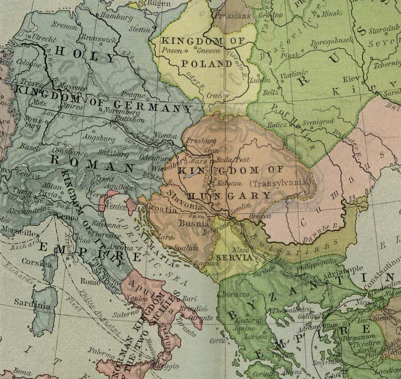
| PopisEurope mediterranean 1190 cropped.jpg |
English: Map of Europe, ca. 1190 A.D. |
| Dátum |
medzi 1923 a 1926 date QS:P,+1923-00-00T00:00:00Z/8,P1319,+1923-00-00T00:00:00Z/9,P1326,+1926-00-00T00:00:00Z/9 |
| Zdroj | Cropped from a map from the Historical Atlas by William Shepherd (1923–26), which is in the public domain in U.S. (http://www.lib.utexas.edu/maps/historical/shepherd/europe_mediterranean_1190.jpg) |
| Autor | William Shepherd |
| Ďalšie verzie | Europe mediterranean 1190.jpg |
Licencovanie
| Public domainPublic domainfalsefalse |
|
Toto dílo je volné také v zemích, jejichž právní řád chrání majetková autorská práva po dobu života autora a 70 let po jeho smrti.
| |
| Tento súbor bol identifikovaný, že nemá žiadne známe obmedzenia vyplývajúce z autorského zákona vrátane všetkých súvisiacich a susedných práv. | |
https://creativecommons.org/publicdomain/mark/1.0/PDMCreative Commons Public Domain Mark 1.0falsefalse
Pôvodný záznam nahrávaní
- 2009-05-27 11:46 Hobartimus 796×753× (263194 bytes) {{Information |Description = Map of europe, cropped ca. 1190 A.D. |Source = Shrinked version of a map from the ''Historical Atlas'' by William Shepherd (1923-26), which is in the public domain in U.S. ( http://www.lib.utexas.edu/maps/historic
História súboru
Po kliknutí na dátum/čas uvidíte ako súbor vyzeral vtedy.
| Dátum/Čas | Náhľad | Rozmery | Používateľ | Komentár | |
|---|---|---|---|---|---|
| aktuálna | 14:48, 14. august 2011 | | 796 × 753 (257 KB) | File Upload Bot (Magnus Manske) | {{BotMoveToCommons|en.wikipedia|year={{subst:CURRENTYEAR}}|month={{subst:CURRENTMONTHNAME}}|day={{subst:CURRENTDAY}}}} {{Information |Description={{en|Map of europe, cropped ca. 1190 A.D.}} |Source=Transferred from [http://en.wikipedia.org en.wikipedia]; |
Použitie súboru
Na tento súbor odkazuje nasledujúca stránka:
Globálne využitie súborov
Nasledovné ďalšie wiki používajú tento súbor:
- Použitie na ar.wikipedia.org
- Použitie na ary.wikipedia.org
- Použitie na azb.wikipedia.org
- Použitie na bn.wikipedia.org
- Použitie na br.wikipedia.org
- Použitie na de.wikipedia.org
- Použitie na el.wikipedia.org
- Použitie na en.wikipedia.org
- Použitie na es.wikipedia.org
- Použitie na et.wikipedia.org
- Použitie na fa.wikipedia.org
- Použitie na fr.wikipedia.org
- Použitie na he.wikipedia.org
- Použitie na hu.wikipedia.org
- Použitie na id.wikipedia.org
- Použitie na id.wikibooks.org
- Použitie na io.wikipedia.org
- Použitie na it.wikipedia.org
Zobraziť ďalšie globálne použitie tohto súboru.
Metadáta
Tento súbor obsahuje ďalšie informácie, pravdepodobne pochádzajúce z digitálneho fotoaparátu či skenera, ktorý ho vytvoril alebo digitalizoval. Ak bol súbor zmenený, niektoré podrobnosti sa nemusia plne zhodovať so zmeneným súborom.
| Horizontálne rozlíšenie | 78,74 dpc |
|---|---|
| Vertikálne rozlíšenie | 78,74 dpc |
| Použitý softvér | Paint.NET v3.22 |