Файл:GeneralMapOfDistancesAndHistoricCapitals.jpg
З Вікіпедії, безкоштовно encyclopedia
Розмір при попередньому перегляді: 744 × 599 пікселів. Інші роздільності: 298 × 240 пікселів | 596 × 480 пікселів | 953 × 768 пікселів | 1271 × 1024 пікселів | 2542 × 2048 пікселів | 3493 × 2814 пікселів.
Повна роздільність (3493 × 2814 пікселів, розмір файлу: 6,14 МБ, MIME-тип: image/jpeg)
| Відомості про цей файл містяться на Вікісховищі — централізованому сховищі вільних файлів мультимедіа для використання у проектах Фонду Вікімедіа. |
Опис файлу
| Назва |
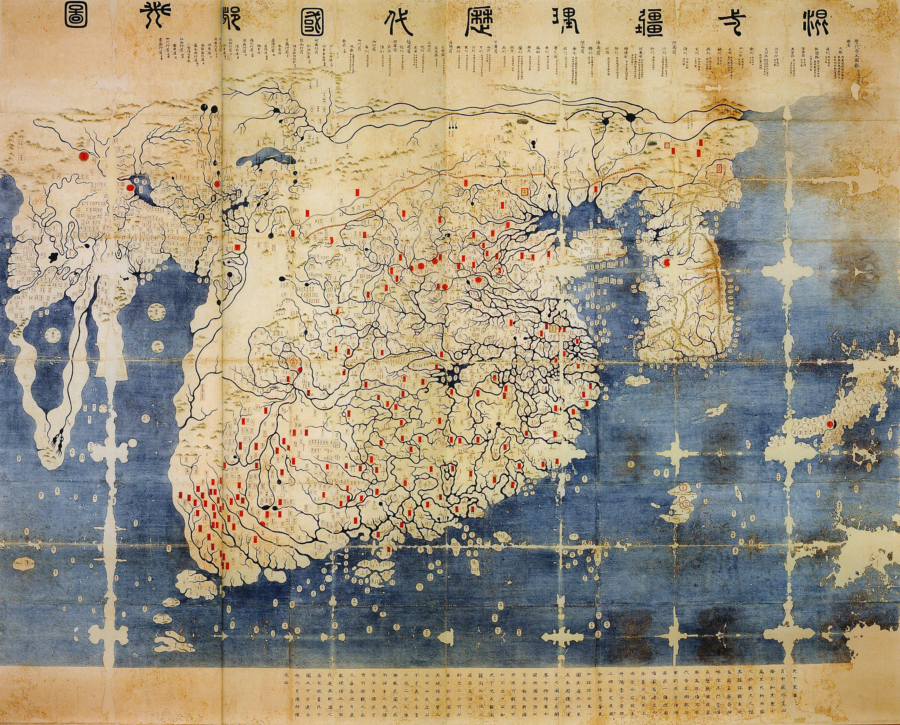
中文:混一疆理歷代國都之圖
한국어: 혼일강리역대국도지도
English: Kangnido |
| ОписGeneralMapOfDistancesAndHistoricCapitals.jpg |
English: General map of the distances and the historic capitals (chinese: Hunyi jiangli lidai guodu zhi tu; japanese: Kon'itsu kyoori rekidai kokuto no zu), Korea, roughly 1402. Ink and paint on paper. Height 220 cm, width 289 cm. Honkoo-ji Tokiwa Museum of Historical Materials, Shimabara, Nagasaki prefecture. Based on two Chinese maps from the 14th century, Shengjiao guangbei tu (Big map that shows the pronounciation of place names) and Hunyi jiangli tu (General map of the distances also showing historical capitals [of China]). Both maps were brought to Korea in 1368, and put together to one new map around 1402. The most obvious feature distinguishing this later version from the original Kangnido is the more correct size and orientation of Japan. The geographical knowledge represented in the map beyond China and Korea seems mainly a result of 14th century trade connections within the Mongol Empire. On the western edge of the map the names Marseille and Sevilla have been identified. Note the depiction of the Cape of Good Hope, the second-earliest known to date. Note: The "crack" on the left side of the image is due to the map being printed on two adjacent pages in the source, an exhibition catalogue. It is not from the original (just in case someone might wonder).
한국어: 혼일강리역대국도지도, 1402년. |
| Час створення | |
| Джерело | Dschingis Khan und seine Erben (exhibition catalogue), München 2005, p. 336/7 |
| Творець |
Kim Sahyung, Lee Moo, Lee Hui |
| Geotemporal data | |
| Зображений час | |
| Геоприв'язка | Геоприв'язана мапа у Wikimaps Warper Якщо недоречно, будь ласка, визначте warp_status = skip щоб приховати. |
| Bibliographic data | |
| Мова | Hanja |
Ліцензування
|
Це зображення (чи мультимедійний файл) перебуває в суспільному надбанні у всьому світі через те, що термін охорони закінчився (минуло 70 років з дня смерті автора або з моменту першої публікації).
Таким чином, ця репродукція також перебуває в суспільному надбанні. Це стосується репродукцій, створених у США (див. справу Bridgeman Art Library v. Corel Corp.), Німеччині та багатьох інших країнах.
| |||||
Підписи
Додайте однорядкове пояснення, що саме репрезентує цей файл
General map of the distances and the historic capitals, Korea, roughly 1402, including Marseille and the Cape of Good Hope.
Об'єкти, показані на цьому файлі
зображує
image/jpeg
Історія файлу
Клацніть на дату/час, щоб переглянути, як тоді виглядав файл.
| Дата/час | Мініатюра | Розмір об'єкта | Користувач | Коментар | |
|---|---|---|---|---|---|
| поточний | 14:40, 11 червня 2008 | | 3493 × 2814 (6,14 МБ) | Yaan | == Summary == {{Information |Description = General map of the distances and the historic capitals (chinese: Hunyi jiangli lidai guodu zhi tu; japanese: Kon'itsu kyoori rekidai kokuto no zu), Korea, roughly 1470. Ink and paint on paper. Height 220 cm, widt |
Використання файлу
Такі сторінки використовують цей файл:
Глобальне використання файлу
Цей файл використовують такі інші вікі:
- Використання в en.wikipedia.org
- Використання в fr.wikipedia.org
- Використання в fr.wikiversity.org
- Використання в ko.wikipedia.org
- Використання в ru.wikipedia.org
- Використання в www.wikidata.org
- Використання в zh.wikipedia.org
Метадані
Файл містить додаткові дані, які зазвичай додаються цифровими камерами чи сканерами. Якщо файл редагувався після створення, то деякі параметри можуть не відповідати цьому зображенню.
| _error | 0 |
|---|