Файл:Rzeczpospolita.png
З Вікіпедії, безкоштовно encyclopedia
Повна роздільність (2000 × 1568 пікселів, розмір файлу: 332 КБ, MIME-тип: image/png)
| Відомості про цей файл містяться на Вікісховищі — централізованому сховищі вільних файлів мультимедіа для використання у проектах Фонду Вікімедіа. |
Опис файлу
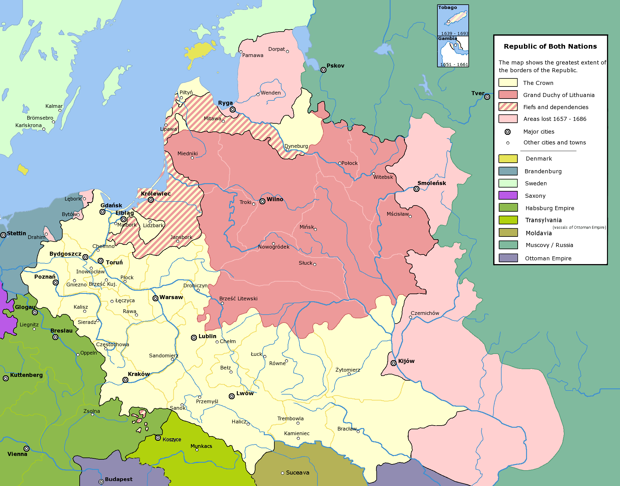
| ОписRzeczpospolita.png |
English: Commonwealth of Both Nations at the peak of its strength. The areas marked with light pink were lost to:
|
| Час створення | |
| Джерело | Власна робота |
| Автор | Halibutt |
| Ліцензія (Повторне використання цього файлу) |
GFDL, see below |
| Інші версії |
|

|
Це зображення невідомого типу «historical map» має бути конвертоване у векторний формат SVG. Це дає декілька переваг, докладніше про які Ви можете прочитати на сторінці Commons:Media for cleanup. Якщо Вам вже зараз доступна векторна версія даного зображення, завантажте її, будь ласка. Після завантаження замініть цей шаблон на такий: {{vector version available|Назва_завантаженого_файлу.svg}}.
|
Ліцензування
Since the legal status of the above comment has been questioned, I hereby grant anyone the right to treat it as either a standard copyright notice, invariant section, legal statement, legal advice, friendly suggestion or a mere comment, depending on his or hers own choice. |
|

History of Poland
The following is a list of maps created by Halibutt and uploaded to commons, as well as their present and projected derivatives.
| Parent Image | Image | Description | |||||||||||
|---|---|---|---|---|---|---|---|---|---|---|---|---|---|
| Maps by Halibutt | |||||||||||||
| Image:Rzeczpospolita.png | Image:Rzeczpospolita.png | The Republic in 17th and 18th century | |||||||||||
| Image:Rzeczpospolita 1600.png | The Republic after the Treaty of Dywilino | ||||||||||||
| Image:Rzeczpospolita voivodships.png | Voivodships of The Republic | ||||||||||||
| Image:Rzeczpospolita_Potop.png | The Republic during The Deluge and Chmielnicki Uprising, with major battles of the era marked | ||||||||||||
| Magnates and their lands and domains | |||||||||||||
| 1st • 2nd • 3rd | Partitions of Poland | ||||||||||||
| War of the constitution | |||||||||||||
| Image:Rzeczpospolita.xcf | SOURCE FILE - GIMP format | ||||||||||||
| Image:Poland 1939.png | Image:Poland 1939.png | Poland in 1939 | |||||||||||
| Image:Dywizje wrzesien 1.png | Order of Battle on September 1st, during the Polish Defence War of 1939 | ||||||||||||
| Image:Poland 1939.xcf | SOURCE FILE - GIMP format | ||||||||||||
| Image:Polska kontur bialy.png | Image:Polska kontur bialy.png | Contour map of Poland AD 1999, for use with various locator maps | |||||||||||
| Image:Rzeczpospolita 1923.png | Image:Rzeczpospolita 1923.png | Map of Poland 1918-1939, currently under development | |||||||||||
| Image:PBW March 1919.png | Polish-Bolshevik War - fronts in March of 1919 | ||||||||||||
| Image:PBW December 1919.png | Polish-Bolshevik War - fronts in December of 1919 | ||||||||||||
| Image:PBW June 1920.png | Polish-Bolshevik War - fronts in July of 1920 | ||||||||||||
| Image:PBW August 1920.png | Polish-Bolshevik War - fronts in August of 1920 | ||||||||||||
| Polish Defence War of 1939 | |||||||||||||
| Polish areas annexed by Germany, Lithuania, Slovakia and the Soviet Union | |||||||||||||
| German concentration camps in Poland | |||||||||||||
| Curzon line | |||||||||||||
| Major battles of the Polish-Bolshevik War | |||||||||||||
| names • no names | Polish/Czechoslovak/Lithuanian/German/Ukrainian claims in 1920's | ||||||||||||
| Image:Rzeczpospolita Central Lithuania.png | Central Lithuania | ||||||||||||
| Image:Rzeczpospolita Lithuania claims.png | Central Lithuania as compared with other Lithuanian claims | ||||||||||||
| Image:Rzeczpospolita 1789-1920.png | Post-1922 borders compared with the territory of Poland before the partitions | ||||||||||||
| Warsaw Uprising and the Operation Tempest | |||||||||||||
| Poland partitioned between the Soviets and the Germans | |||||||||||||
| Image:Rzeczpospolita 1939 Polish divisions.png | Polish divisions on September 1, 1939 | ||||||||||||
| Home Army inspectorates | |||||||||||||
| Image:Rzeczpospolita 1922.xcf | SOURCE FILE - GIMP format | ||||||||||||
| Image:Rzeczpospolita 1937.svg | Vector version!!!! | layered version available on request | |||||||||||

|
This image (or all images in this category) uses inside labels or attached captions in a specific script or language and should be converted to a language neutral form. This would allow its use in all Wikimedia projects and, more importantly, all Wikimedia languages.
Bahasa Melayu ∙ català ∙ čeština ∙ Deutsch ∙ English ∙ español ∙ français ∙ italiano ∙ magyar ∙ Nederlands ∙ Plattdüütsch ∙ português ∙ sicilianu ∙ slovenčina ∙ suomi ∙ беларуская (тарашкевіца) ∙ македонски ∙ русский ∙ српски / srpski ∙ 한국어 ∙ 日本語 ∙ 中文 ∙ 中文(简体) ∙ فارسی ∙ +/− |
Підписи
Об'єкти, показані на цьому файлі
зображує
Якесь значення без елемента на сайті Вікідані
8 грудня 2004
Історія файлу
Клацніть на дату/час, щоб переглянути, як тоді виглядав файл.
| Дата/час | Мініатюра | Розмір об'єкта | Користувач | Коментар | |
|---|---|---|---|---|---|
| поточний | 14:37, 6 травня 2016 | | 2000 × 1568 (332 КБ) | Julieta39 | Cosmetic changes: see sources in the discussion page of today. |
| 10:40, 8 грудня 2009 |  | 2000 × 1568 (221 КБ) | Tryphon | Removed watermark. | |
| 19:34, 13 грудня 2004 |  | 2000 × 1568 (304 КБ) | Halibutt | Ok, final version at last (unless you have some more comments or suggestions) | |
| 07:47, 10 грудня 2004 |  | 2000 × 1568 (297 КБ) | Halibutt | final version? | |
| 01:36, 10 грудня 2004 |  | 2000 × 1568 (193 КБ) | Halibutt | new update | |
| 03:23, 8 грудня 2004 |  | 2000 × 1568 (141 КБ) | Halibutt | Commonwealth of Both Nations at the peak of its strength<br>Beta version of a map by Halibutt<br>{{User:Halibutt/GFDL}} |
Використання файлу
Такі сторінки використовують цей файл:
Глобальне використання файлу
Цей файл використовують такі інші вікі:
- Використання в ar.wikipedia.org
- Використання в arz.wikipedia.org
- Використання в azb.wikipedia.org
- Використання в bg.wikipedia.org
- Використання в br.wikipedia.org
- Використання в ca.wikipedia.org
- Використання в da.wikipedia.org
- Використання в de.wikipedia.org
- Використання в de.wikibooks.org
- Використання в en.wikipedia.org
- Використання в eo.wikipedia.org
- Використання в et.wikipedia.org
- Використання в fi.wikipedia.org
- Використання в fr.wikipedia.org
- Використання в gl.wikipedia.org
- Використання в hr.wikipedia.org
- Використання в hsb.wikipedia.org
- Використання в hu.wikipedia.org
- Використання в id.wikipedia.org
- Використання в it.wikipedia.org
- Використання в ja.wikipedia.org
Переглянути сторінку глобального використання цього файлу.
Метадані
Файл містить додаткові дані, які зазвичай додаються цифровими камерами чи сканерами. Якщо файл редагувався після створення, то деякі параметри можуть не відповідати цьому зображенню.
| Горизонтальна роздільна здатність | 28,35 точок на сантиметр |
|---|---|
| Вертикальна роздільна здатність | 28,35 точок на сантиметр |