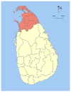
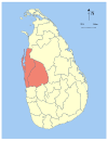
斯里兰卡划分为9个省(පලාත)和25个行政区(දිස්ත්රික්ක):

省列表
| 省份 | 所在位置 | 省会 | 建立时间 | 面积 in km2 (mi2[1] |
水域面积 in km2 (mi2)[1] |
总面积 in km2 (mi2)[1] |
人口 (2012)[2] |
人口密度 per km2 (per mi2) |
|---|---|---|---|---|---|---|---|---|
| 中央省 | 
|
康提 | 1833年10月1日 | 5,575(2,153) | 99(38) | 5,674(2,191) | 2,571,557 | 461(1,190) |
| 东部省 | 
|
亭可马里 | 1833年10月1日 | 9,361(3,614) | 635(245) | 9,996(3,859) | 1,555,510 | 166(430) |
| 北中省 | 
|
阿努拉德普勒 | 1873年 | 9,741(3,761) | 731(282) | 10,472(4,043) | 1,266,663 | 130(340) |
| 北部省 | 
|
贾夫纳 | 1833年10月1日 | 8,290(3,200) | 594(229) | 8,884(3,430) | 1,061,315 | 128(330) |
| 西北省 | 
|
库鲁内格勒 | 1845年 | 7,506(2,898) | 382(147) | 7,888(3,046) | 2,380,861 | 317(820) |
| 萨伯勒格穆沃省 | 
|
拉特纳普勒 | 1889年 | 4,921(1,900) | 47(18) | 4,968(1,918) | 1,928,655 | 392(1,020) |
| 南部省 | 
|
加勒 | 1833年10月1日 | 5,383(2,078) | 161(62) | 5,544(2,141) | 2,477,285 | 460(1,200) |
| 乌沃省 | 
|
巴杜勒 | 1886年 | 8,335(3,218) | 165(64) | 8,500(3,300) | 1,266,463 | 152(390) |
| 西部省 | 
|
科伦坡 | 1833年10月1日 | 3,593(1,387) | 91(35) | 3,684(1,422) | 5,851,130 | 1,628(4,220) |
| 总计 | 62,705(24,211) | 2,905(1,122) | 65,610(25,330) | 20,359,439 | 325(840) |
参考资料
延伸阅读
外部链接
Wikiwand in your browser!
Seamless Wikipedia browsing. On steroids.
Every time you click a link to Wikipedia, Wiktionary or Wikiquote in your browser's search results, it will show the modern Wikiwand interface.
Wikiwand extension is a five stars, simple, with minimum permission required to keep your browsing private, safe and transparent.
