File:Europe_large_topographic_location_map.png
維基百科,自由的 encyclopedia
預覽大小:771 × 600 像素。 其他解析度:309 × 240 像素 | 617 × 480 像素 | 987 × 768 像素 | 1,280 × 996 像素 | 2,334 × 1,816 像素。
原始檔案 (2,334 × 1,816 像素,檔案大小:1.19 MB,MIME 類型:image/png)
摘要
{{Information
|description=
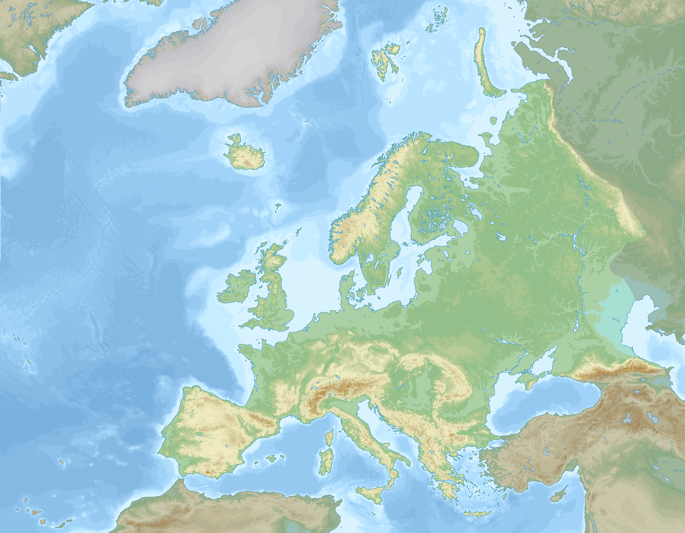
English: Location map of Europe stretching to the Canary Islands, Azores, Franz Joseph land and the entire Caucasus. A definition of Europe as bounded by the Caucasus mountains, Ural river and Ural mountains is shown.
negative
0 to 100 m
100 to 200 m
200 to 300 m
300 to 400 m
400 to 500 m
500 to 600 m
600 to 800 m
800 to 1000 m
1000 to 1200 m
1200 to 1600 m
1600 to 2000 m
2000 to 2500 m
2500 to 3000 m
3000 to 3500 m
3500 to 4000 m
above 4000 m
0 to 100 m
100 to 200 m
200 to 500 m
500 to 1000 m
1000 to 2000 m
2000 to 3000 m
3000 to 4000 m
4000 to 5000 m
below 5000 m
Data source: GEBCO 2022
Elevations (in Europe):
Sea depths:
Map Info
| Projection: | Stereographic |
|---|---|
| Projection center: | North Pole |
| Vertical meridian: | 15.000° E |
| Position of vertical meridian: | 55.4113 % of image width from left edge |
| Position of pole: | 8.9207 % of image height above top edge |
| Scale at pole: | 1.8011 % of image height ( = 1.4013 % of image width) per degree |
| x (%)= | 55.4113 + 160.5827*tan(pi*(90 - $1)/360)*sin(pi*($2 - 15)/180)
|
|---|---|
| y (%)= | -8.9207 + 206.3877*tan(pi*(90 - $1)/360)*cos(pi*($2 - 15)/180)
|
| $1: | latitude in degrees (positive for all locations on map). |
| $2: | longitude in degrees (positive or negative). |
| x (%): | x coordinate expressed as percentage of image width (measured from left edge). |
| y (%): | y coordinate expressed as percentage of image height (measured from top edge). |
授權條款
我,本作品的著作權持有者,決定用以下授權條款發佈本作品:
此檔案採用創用CC 姓名標示-相同方式分享 4.0 國際授權條款。
- 您可以自由:
- 分享 – 複製、發佈和傳播本作品
- 重新修改 – 創作演繹作品
- 惟需遵照下列條件:
- 姓名標示 – 您必須指名出正確的製作者,和提供授權條款的連結,以及表示是否有對內容上做出變更。您可以用任何合理的方式來行動,但不得以任何方式表明授權條款是對您許可或是由您所使用。
- 相同方式分享 – 如果您利用本素材進行再混合、轉換或創作,您必須基於如同原先的相同或兼容的條款,來分布您的貢獻成品。
說明
添加單行說明來描述出檔案所代表的內容
沒有維基數據項目的某些值
1 12 2022
image/png
檔案歷史
點選日期/時間以檢視該時間的檔案版本。
| 日期/時間 | 縮圖 | 尺寸 | 使用者 | 備註 | |
|---|---|---|---|---|---|
| 目前 | 2023年9月5日 (二) 20:03 | | 2,334 × 1,816(1.19 MB) | GrandEscogriffe | darker non-european lands; coastlines in blue |
| 2022年12月1日 (四) 18:32 |  | 2,334 × 1,816(1.17 MB) | GrandEscogriffe | Uploaded own work with UploadWizard |
檔案用途
沒有使用此檔案的頁面。
全域檔案使用狀況
以下其他 wiki 使用了這個檔案:
- en.wikipedia.org 的使用狀況
- fr.wikipedia.org 的使用狀況
- Mer de Barents
- Mer Égée
- Dardanelles
- Nouvelle-Zemble
- Île Jan Mayen
- Rockall
- Île aux Ours
- Mer de Kara
- Liste des départements de France par altitude
- Mer Blanche
- Kolbeinsey
- Mer de Norvège
- Mer du Groenland
- Terre François-Joseph
- An Tiaracht
- Gavdos
- Cabo da Roca
- Détroit de Danemark
- Liste des provinces et territoires d'outre-mer des Pays-Bas par point culminant
- Canal de Sicile
- Capelinhos
- Cap Fligely
- Mer d'Irminger
- Baie Baïdaratskaïa
- Liste des régions et provinces d'Italie par altitude
- Mer Caspienne
- Svalbard
- Liste des cantons de Suisse par altitude
- Cap Jelania
- Bjargtangar
- Rossøya
- Mer de Sicile
- Pointe de Tarifa
- Île Victoria (Russie)
- Cap Flissingski
- Îlot de Monchique
- Vatnahverfi
- Fosse Calypso
- Liste des comtés d'Irlande par point culminant
- Liste des Länder d'Allemagne par point culminant
- Modèle:Palette Liste des points culminants des pays d'Europe
- Liste des entités de Belgique par point culminant
- Modèle:Géolocalisation/Europe 2
- Wikipédia:Atelier graphique/Cartes/Archives/décembre 2022
- Liste des provinces d'Espagne par point culminant
- Liste des fylker de Norvège par point culminant
- Liste des Länder d'Autriche par point culminant
- Liste des régions de Finlande par point culminant
檢視此檔案的更多全域使用狀況。