File:Wostok-Station_core32.jpg
維基百科,自由的 encyclopedia
預覽大小:800 × 515 像素。 其他解析度:320 × 206 像素 | 640 × 412 像素 | 1,000 × 644 像素。
原始檔案 (1,000 × 644 像素,檔案大小:89 KB,MIME 類型:image/jpeg)
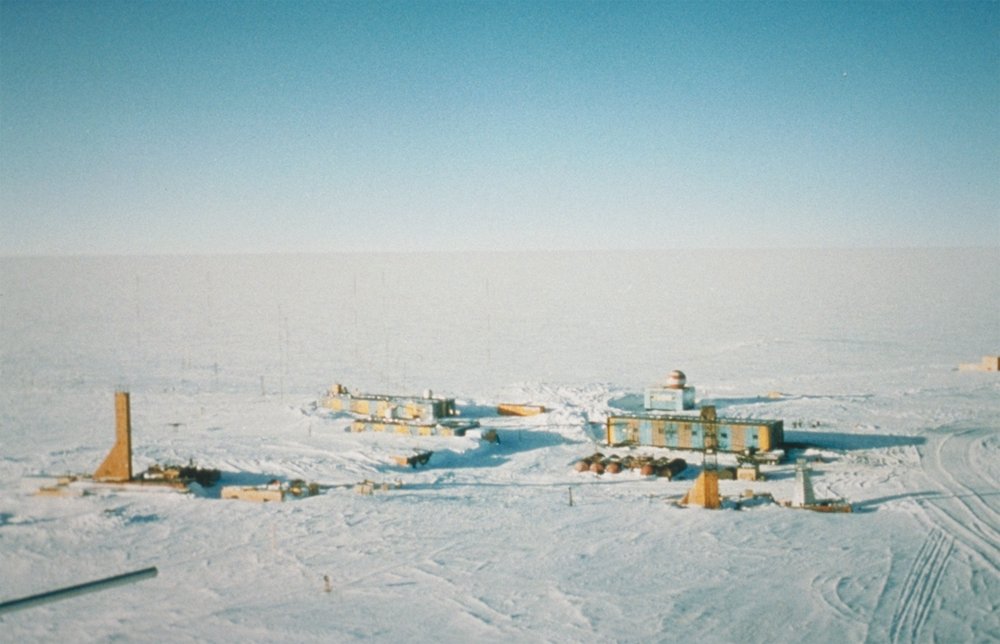
| 描述Wostok-Station core32.jpg | Wostok-Station (NOAA), photo by Todd Sowers, Lamont-Doherty Earth Observatory (LDEO), Columbia University, Palisades, New York, for NOAA. The Vostok site was chosen by the Soviet Union for the deep coring possibilities it offered. French and, later, American scientists became interested in the Soviet research and began to participate in coring activities at the site. This panoramic photo of Vostok Station shows the layout of the camp. The striped building on the left is the power station while the striped building on the right is where researchers sleep and take meals. The building in the background with the red- and white-striped ball on top is the meteorology building. Caves were dug into the ice sheet for storage, keeping cores at an ideal -55 degrees C year round. | ||||
| 日期 | (date attribute of the source file) | ||||
| 來源 | http://www.ngdc.noaa.gov/paleo/slides/slideset/15/15_300_slide.html | ||||
| 作者 | Todd Sowers, Lamont-Doherty Earth Observatory (LDEO), Columbia University, Palisades, New York for NOAA | ||||
| 授權許可 (重用此檔案) |
|
| 拍攝地點 | 78° 27′ 52″ 南, 106° 50′ 50″ 東 | 位於此地的本圖片與其他圖片: OpenStreetMap |
|---|
原始上傳日誌
(All user names refer to de.wikipedia)
- 2004-07-02 17:33 Srbauer 768×494×8 (45575 bytes) Wostok-Station (NOAA)
taken from de.wikipedia; description page is/was here. Original uploader was Srbauer at de.wikipedia
說明
添加單行說明來描述出檔案所代表的內容
Panoramic view of the Russian Vostok Station, Antarctica, 2001.
在此檔案描寫的項目
描繪內容
11 10 2001
視角坐標 繁體中文 (已轉換拼寫)
78°27'51.998"S, 106°50'49.999"E
image/jpeg
檔案歷史
點選日期/時間以檢視該時間的檔案版本。
| 日期/時間 | 縮圖 | 尺寸 | 使用者 | 備註 | |
|---|---|---|---|---|---|
| 目前 | 2007年4月5日 (四) 20:21 | | 1,000 × 644(89 KB) | Raul6 | |
| 2007年2月4日 (日) 12:16 |  | 768 × 494(45 KB) | Hardscarf | {{Information |Description=Wostok-Station (NOAA) Quelle: http://www.ngdc.noaa.gov/paleo/slides/slideset/15/15_300_slide.html Lizenz: PD Beschreibung: Vostok Site The Vostok site was chosen by the Soviet Union for the deep coring possibilities it offer |
檔案用途
下列頁面有用到此檔案:
全域檔案使用狀況
以下其他 wiki 使用了這個檔案:
- ar.wikipedia.org 的使用狀況
- ast.wikipedia.org 的使用狀況
- az.wikipedia.org 的使用狀況
- be-tarask.wikipedia.org 的使用狀況
- be.wikipedia.org 的使用狀況
- bg.wikipedia.org 的使用狀況
- bs.wikipedia.org 的使用狀況
- ca.wikipedia.org 的使用狀況
- ceb.wikipedia.org 的使用狀況
- cs.wikipedia.org 的使用狀況
- cv.wikipedia.org 的使用狀況
- de.wikipedia.org 的使用狀況
- en.wikipedia.org 的使用狀況
- es.wikipedia.org 的使用狀況
- es.wikivoyage.org 的使用狀況
- et.wikipedia.org 的使用狀況
- eu.wikipedia.org 的使用狀況
- fa.wikipedia.org 的使用狀況
- fi.wikipedia.org 的使用狀況
- fr.wikipedia.org 的使用狀況
- he.wikipedia.org 的使用狀況
- hu.wikipedia.org 的使用狀況
- hy.wikipedia.org 的使用狀況
- id.wikipedia.org 的使用狀況
檢視此檔案的更多全域使用狀況。
詮釋資料
此檔案中包含其他資訊,這些資訊可能是由數位相機或掃描器在建立或數位化過程中所新增的。若檔案自原始狀態已被修改,一些詳細資料可能無法完整反映出已修改的檔案。
| JPEG 檔案備註 | The Vostok site was chosen by the Soviet Union for the deep coring possibilities it offered. French and, later, American scientists became interested in the Soviet research and began to participate in coring activities at the site. This panoramic photo of Vostok Station shows the layout of the camp. The striped building on the left is the power station while the striped building on the right is where researchers sleep and take meals. The building in the background with the red- and white-striped ball on top is the meteorology building. Caves were dug into the ice sheet for storage, keeping cores at an ideal -55 degrees C year round. |
|---|