File:GeneralMapOfDistancesAndHistoricCapitals.jpg
維基百科,自由的 encyclopedia
本预览的尺寸:744 × 599像素。 其他分辨率:298 × 240像素 | 596 × 480像素 | 953 × 768像素 | 1,271 × 1,024像素 | 2,542 × 2,048像素 | 3,493 × 2,814像素。
原始文件 (3,493 × 2,814像素,文件大小:6.14 MB,MIME类型:image/jpeg)
摘要
| 标题 |
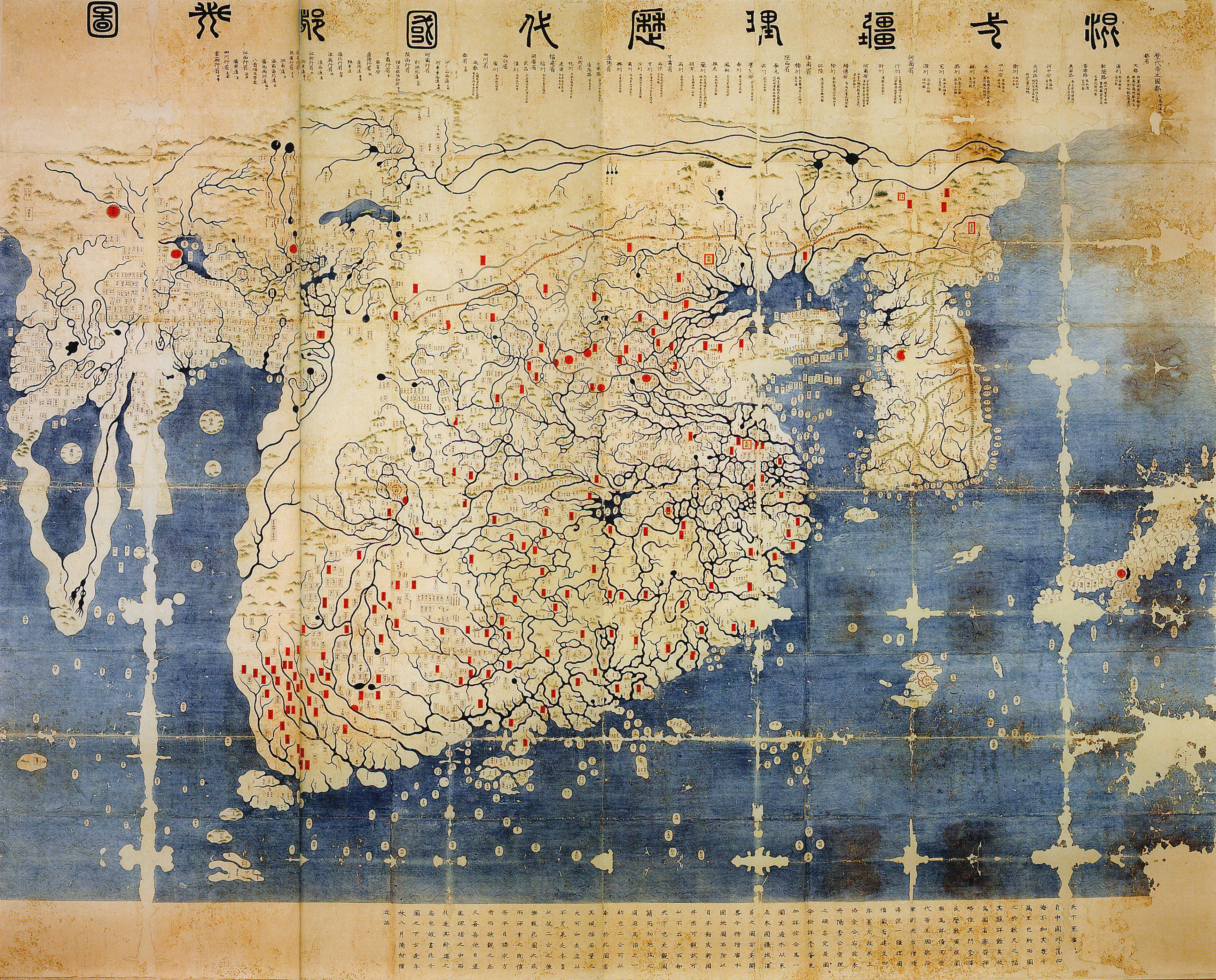
中文:混一疆理歷代國都之圖
한국어: 혼일강리역대국도지도
English: Kangnido |
| 描写GeneralMapOfDistancesAndHistoricCapitals.jpg |
English: General map of the distances and the historic capitals (chinese: Hunyi jiangli lidai guodu zhi tu; japanese: Kon'itsu kyoori rekidai kokuto no zu), Korea, roughly 1402. Ink and paint on paper. Height 220 cm, width 289 cm. Honkoo-ji Tokiwa Museum of Historical Materials, Shimabara, Nagasaki prefecture. Based on two Chinese maps from the 14th century, Shengjiao guangbei tu (Big map that shows the pronounciation of place names) and Hunyi jiangli tu (General map of the distances also showing historical capitals [of China]). Both maps were brought to Korea in 1368, and put together to one new map around 1402. The most obvious feature distinguishing this later version from the original Kangnido is the more correct size and orientation of Japan. The geographical knowledge represented in the map beyond China and Korea seems mainly a result of 14th century trade connections within the Mongol Empire. On the western edge of the map the names Marseille and Sevilla have been identified. Note the depiction of the Cape of Good Hope, the second-earliest known to date. Note: The "crack" on the left side of the image is due to the map being printed on two adjacent pages in the source, an exhibition catalogue. It is not from the original (just in case someone might wonder).
한국어: 혼일강리역대국도지도, 1402년. |
| 日期 | |
| 来源 | Dschingis Khan und seine Erben (exhibition catalogue), München 2005, p. 336/7 |
| 創作作者 |
Kim Sahyung, Lee Moo, Lee Hui |
| Geotemporal data | |
| 描繪日期 | |
| 地理参考 | 地理参考Wikimaps Warper中的地图 如果不适当,请设置 warp_status = skip 为隐藏。 |
| Bibliographic data | |
| 语种 | Hanja |
许可协议
|
这是一个平面公有领域艺术品的忠实摄影副本。原艺术品本身因为下列原因属于公有领域:
维基媒体基金会的官方立场认为:“对平面公有领域艺术品的忠实再制作品也属于公有领域。”
因此,可以认为此摄影副本在美国也属于公有领域。在其他司法管辖区,再利用此内容可能存在限制;参见再利用PD-Art照片了解详细信息。 | |||||
说明
添加一行文字以描述该文件所表现的内容
General map of the distances and the historic capitals, Korea, roughly 1402, including Marseille and the Cape of Good Hope.
此文件中描述的项目
描繪內容
image/jpeg
文件历史
点击某个日期/时间查看对应时刻的文件。
| 日期/时间 | 缩略图 | 大小 | 用户 | 备注 | |
|---|---|---|---|---|---|
| 当前 | 2008年6月11日 (三) 14:40 | | 3,493 × 2,814(6.14 MB) | Yaan | == Summary == {{Information |Description = General map of the distances and the historic capitals (chinese: Hunyi jiangli lidai guodu zhi tu; japanese: Kon'itsu kyoori rekidai kokuto no zu), Korea, roughly 1470. Ink and paint on paper. Height 220 cm, widt |
文件用途
以下页面使用本文件:
全域文件用途
以下其他wiki使用此文件:
- en.wikipedia.org上的用途
- fr.wikipedia.org上的用途
- fr.wikiversity.org上的用途
- ko.wikipedia.org上的用途
- ru.wikipedia.org上的用途
- uk.wikipedia.org上的用途
- www.wikidata.org上的用途
元数据
此文件中包含有扩展的信息。这些信息可能是由数码相机或扫描仪在创建或数字化过程中所添加。
如果此文件的源文件已经被修改,一些信息在修改后的文件中将不能完全反映出来。
| _error | 0 |
|---|