Lêer:Adriatic_Sea_map.png
From Wikipedia, the free encyclopedia
Grootte van hierdie voorskou: 422 × 599 piksels. Ander resolusies: 169 × 240 piksels | 338 × 480 piksels | 704 × 999 piksels.
Oorspronklike lêer (704 × 999 piksels, lêergrootte: 235 KG, MIME-tipe: image/png)
Hierdie lêer kom vanaf Wikimedia Commons en kan ook in ander projekte gebruik word. Die beskrywing op die lêer se inligtingsblad word hieronder weergegee.

|
This locator map image could be re-created using vector graphics as an SVG file. This has several advantages; see Commons:Media for cleanup for more information. If an SVG form of this image is available, please upload it and afterwards replace this template with
{{vector version available|new image name}}.
It is recommended to name the SVG file “Adriatic Sea map.svg”—then the template Vector version available (or Vva) does not need the new image name parameter. |
Opsomming
| BeskrywingAdriatic Sea map.png |
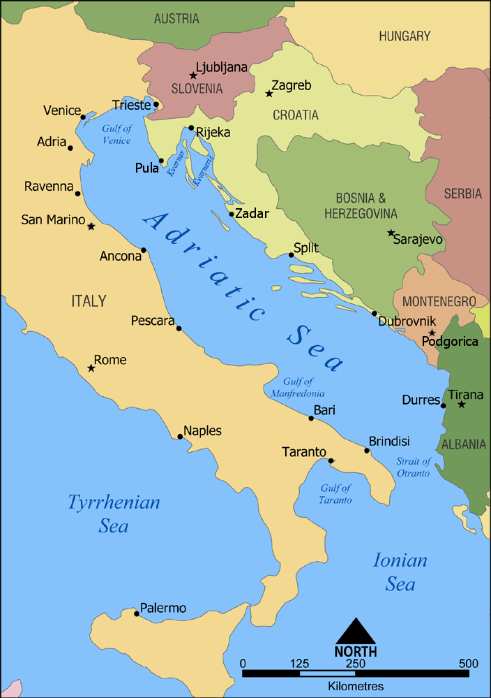
English: A map showing the location of the Adriatic Sea. |
| Datum | |
| Bron | Eie werk |
| Outeur | NormanEinstein |
| Ander weergawes |
|


Lisensiëring
Ek, die outeursreghouer van hierdie werk, publiseer dit onder die volgende lisensie:

|
Toestemming word verleen tot die kopiëring, verspreiding en/of wysiging van hierdie dokument onder die voorwaardes van die GNU-lisensie vir vrye dokumentasie, weergawe 1.2 of enige latere weergawe uitgegee deur die Stigting vir Vrye Sagteware, sonder Invariante Dele, geen Voorbladtekste en geen Agterbladtekste. 'n Kopie van hierdie lisensie is ingesluit in die afdeling getiteld GNU Free Documentation License.http://www.gnu.org/copyleft/fdl.htmlGFDLGNU Free Documentation Licensetruetrue |
| Hierdie lêer is gelisensieer onder die Creative Commons Erkenning-Insgelyks Deel 3.0 Onoorgedraagde lisensie. | ||
| ||
| This licensing tag was added to this file as part of the GFDL licensing update.http://creativecommons.org/licenses/by-sa/3.0/CC BY-SA 3.0Creative Commons Attribution-Share Alike 3.0truetrue |
U kan die lisensie van u keuse kies.
Captions
Add a one-line explanation of what this file represents
Map of the Adriatic Sea
Items portrayed in this file
uitbeelding
some value
20 Mei 2005
media type Engels
image/png
checksum Engels
40987318083fe10a13fc70c8be8536ad85d5d5cd
data size Engels
240 430 greep
height Engels
999 pieksel
width Engels
704 pieksel
Lêergeskiedenis
Klik op die datum/tyd om te sien hoe die lêer destyds gelyk het.
| Datum/Tyd | Duimnael | Dimensies | Gebruiker | Opmerking | |
|---|---|---|---|---|---|
| huidig | 16:00, 23 Februarie 2023 | | 704 × 999 (235 KG) | Doremo | slightly trimmed, marked 2008 border change |
| 09:15, 9 Februarie 2012 |  | 735 × 1 000 (239 KG) | Joy | Added Pula, Zadar, Podgorica | |
| 19:20, 18 Januarie 2010 |  | 735 × 1 000 (302 KG) | Buttons~commonswiki | Reverted to version as of 02:46, 10 July 2006 Kosovo is not recognized by the UN or EU | |
| 18:57, 10 September 2008 |  | 735 × 1 000 (256 KG) | Admiral Norton | Reverted to Kosovo version, it's independent now | |
| 02:46, 10 Julie 2006 |  | 735 × 1 000 (302 KG) | NormanEinstein | Reverting to March 2 2006 version; didn't realize Hipi Zhdripi's edits included showing Kosovo as a separate country. | |
| 16:41, 9 Julie 2006 |  | 735 × 1 000 (256 KG) | NormanEinstein | Reverting to last version by Hipi Zhdripi. Philjon, if you want to change the colours and text, that's fine, but upload it as a new image. | |
| 17:40, 25 Junie 2006 |  | 441 × 600 (33 KG) | Philjon~commonswiki | ||
| 17:39, 25 Junie 2006 |  | 441 × 600 (33 KG) | Philjon~commonswiki | Ameloliored version of this map | |
| 22:27, 24 Junie 2006 |  | 441 × 600 (34 KG) | Philjon~commonswiki | Image améliorée par ~~~ {{Atelier graphique carte}} | |
| 05:17, 2 April 2006 |  | 735 × 1 000 (256 KG) | Hipi Zhdripi~commonswiki |
Lêergebruik
Die volgende bladsy gebruik dié lêer:
Globale lêergebruik
Die volgende ander wiki's gebruik hierdie lêer:
- Gebruik in als.wikipedia.org
- Gebruik in am.wikipedia.org
- Gebruik in an.wikipedia.org
- Gebruik in azb.wikipedia.org
- Gebruik in az.wiktionary.org
- Gebruik in ban.wikipedia.org
- Gebruik in bar.wikipedia.org
- Gebruik in ba.wikipedia.org
- Gebruik in be-tarask.wikipedia.org
- Gebruik in be.wikipedia.org
- Gebruik in bh.wikipedia.org
- Gebruik in bn.wikipedia.org
- Gebruik in bs.wikipedia.org
- Gebruik in cdo.wikipedia.org
- Gebruik in ce.wikipedia.org
- Gebruik in ckb.wikipedia.org
- Gebruik in da.wikipedia.org
- Gebruik in de.wikipedia.org
- Gebruik in diq.wikipedia.org
- Gebruik in el.wikipedia.org
- Gebruik in el.wiktionary.org
- Gebruik in eml.wikipedia.org
- Gebruik in en.wikipedia.org
- Croatian Navy
- Austro-Hungarian Navy
- User:NormanEinstein/gallery
- Wikipedia:Graphics Lab/Images to improve/Archive/Apr 2008
- Adriatic Sea
- Gulf of Manfredonia
- Battle of Durazzo (1918)
- 1918–1920 unrest in Split
- User:Chickstarr404/Gather lists/12385 – "The Eastern Shores of the Adriatic in 1863" by Emily Anne Beaufort
- User:Chickstarr404/Gather lists
- Fauna of Montenegro
- Gebruik in es.wikipedia.org
- Gebruik in fa.wikipedia.org
- Gebruik in fi.wikipedia.org
- Gebruik in frp.wikipedia.org
- Gebruik in frr.wikipedia.org
- Gebruik in fr.wikipedia.org
- Gebruik in gag.wikipedia.org
- Gebruik in hak.wikipedia.org
- Gebruik in id.wikipedia.org
- Gebruik in ilo.wikipedia.org
- Gebruik in incubator.wikimedia.org
Wys meer globale gebruik van die lêer.
Metadata
Die lêer bevat aanvullende inligting wat moontlik deur 'n digitale kamera of skandeerder bygevoeg is.
As die lêer verander is, sal sekere inligting dalk nie meer ooreenkom met dié van die gewysigde lêer nie.
| Horisontale resolusie | 37,79 dpc |
|---|---|
| Vertikale resolusie | 37,79 dpc |
Ontsluit van "https://af.wikipedia.org/wiki/Lêer:Adriatic_Sea_map.png"