Lêer:Chennai.png
From Wikipedia, the free encyclopedia
Geen hoër resolusie is beskikbaar nie.
Chennai.png (219 × 164 piksels, lêergrootte: 13 KG, MIME-tipe: image/png)
Hierdie lêer kom vanaf Wikimedia Commons en kan ook in ander projekte gebruik word. Die beskrywing op die lêer se inligtingsblad word hieronder weergegee.
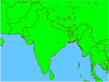
| BeskrywingChennai.png |
English: This is an incorrect representation of the Republic of India. For a proper geographically correct version of the Republic of India click here: http://www.worldatlas.com/webimage/countrys/asia/lgcolor/incolor.htm This map is an objective illustration showing even the "disputed" region of Kashmir which forms an integral part of India. This map was generated using all open-source software on an open-source unix operating system. The map itself and the marking of the co-ordinates were done using GMT software, and conversion to png format was done using ImageMagick. Please notice this is different form using graphics arts software tools to create maps or other pictures. In fact, this map was created by issuing only 3 command lines from a unix shell, without even using any GUI -- and GUI was used only to view the final picture before uploading it. GMT is a geographic and cartographic set of tools, with extensive capabilities and options. |
| Datum | |
| Bron | Eie werk |
| Outeur | OnbekendUnknown author |

|
Toestemming word verleen tot die kopiëring, verspreiding en/of wysiging van hierdie dokument onder die voorwaardes van die GNU-lisensie vir vrye dokumentasie, weergawe 1.2 of enige latere weergawe uitgegee deur die Stigting vir Vrye Sagteware, sonder Invariante Dele, geen Voorbladtekste en geen Agterbladtekste. 'n Kopie van hierdie lisensie is ingesluit in die afdeling getiteld GNU Free Documentation License.http://www.gnu.org/copyleft/fdl.htmlGFDLGNU Free Documentation Licensetruetrue |
| Hierdie lêer is gelisensieer onder die Creative Commons Erkenning-Insgelyks Deel 3.0 Onoorgedraagde lisensie. | ||
| ||
| This licensing tag was added to this file as part of the GFDL licensing update.http://creativecommons.org/licenses/by-sa/3.0/CC BY-SA 3.0Creative Commons Attribution-Share Alike 3.0truetrue |
Captions
Add a one-line explanation of what this file represents
Items portrayed in this file
uitbeelding
source of file Engels
media type Engels
image/png
checksum Engels
6012e2a2568448c066eb280a053008ae10785518
data size Engels
13 531 greep
height Engels
164 pieksel
width Engels
219 pieksel
Lêergeskiedenis
Klik op die datum/tyd om te sien hoe die lêer destyds gelyk het.
| Datum/Tyd | Duimnael | Dimensies | Gebruiker | Opmerking | |
|---|---|---|---|---|---|
| huidig | 13:51, 6 Januarie 2005 | | 219 × 164 (13 KG) | Sebastian Wallroth | This is an incorrect representation of the Republic of India. For a proper geographically correct version of the Republic of India click here: http://www.worldatlas.com/webimage/countrys/asia/lgcolor/incolor.htm This map is an objective illustration showi |
Lêergebruik
Die volgende bladsy gebruik dié lêer:
Globale lêergebruik
Die volgende ander wiki's gebruik hierdie lêer:
- Gebruik in qu.wikipedia.org
Ontsluit van "https://af.wikipedia.org/wiki/Lêer:Chennai.png"