Lêer:Non-Native_American_Nations_Control_over_N_America_1750-2008.gif
From Wikipedia, the free encyclopedia
Grootte van hierdie voorskou: 536 × 600 piksels. Ander resolusies: 215 × 240 piksels | 429 × 480 piksels | 700 × 783 piksels.
Oorspronklike lêer (700 × 783 piksels, lêergrootte: 537 KG, MIME-tipe: image/gif, herhalend, 79 rame, 1 min 22 s)
Hierdie lêer kom vanaf Wikimedia Commons en kan ook in ander projekte gebruik word. Die beskrywing op die lêer se inligtingsblad word hieronder weergegee.
Opsomming
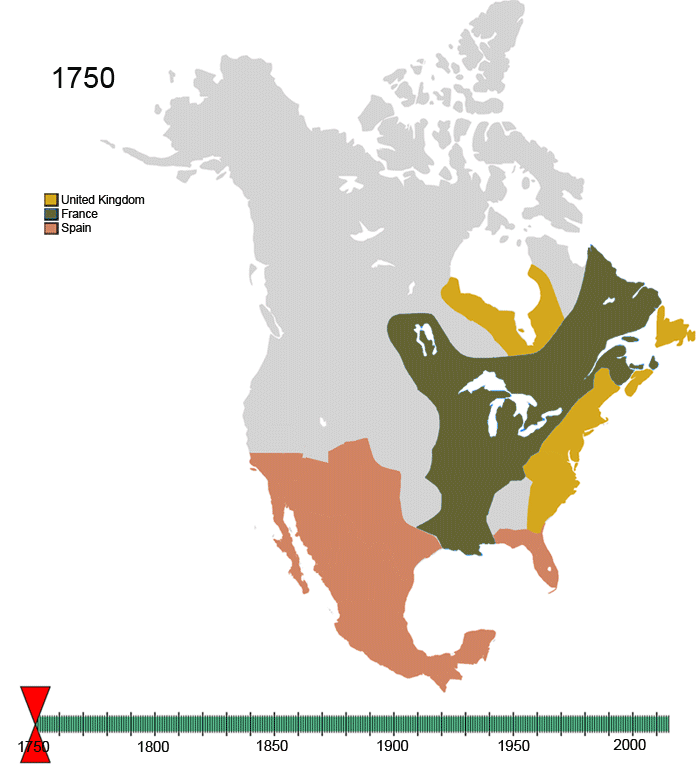
| BeskrywingNon-Native American Nations Control over N America 1750-2008.gif | Non-Native-American Nation's Control over North America circe 1750-2008 | |||
| Datum | ||||
| Bron | Eie werk | |||
| Outeur | Esemono | |||
| Toestemming (Hergebruik van die lêer) |
|
|||
| Ander weergawes |
|


English: Animated Map of the history of North America — from 1750 to 2008.
- Showing the changing control of colonial territories and independent nations, over 250 years in North America.
- NOTE: The declining—lost control of the Indigenous peoples of North America over their traditional territories and established homelands and cultural regions — is not considered in this euro-centric map.
| France | |||
| Present day Canada | |||
|---|---|---|---|
| Canada | |||
| Dominion of Newfoundland | |||
| France | |||
| Britain | |||
| Present day USA | |||
| United States of America | |||
| California Republic | |||
| Confederate States of America | |||
| France | |||
| Republic of Indian Stream | No flag | ||
| Republic of Texas | |||
| Republic of Vermont | |||
| Republic of West Florida | |||
| Russia | |||
| Spain | |||
| Britain | |||
| Present day Mexico | |||
| Federal Republic of Central America | |||
| Mexico | |||
| Spain | |||
| Republic of the Rio Grande | |||
| Yucatán | |||
For notes on the individual border changes see Territorial evolution of North America. To make your own animated image use the slides below:


See Also
-
 North America
 -
 Central America
 -
 Balkans
 -
 South America
 -
 Canada
 -
 United States
 -
 Mexico
 -
 Blank map


Captions
Add a one-line explanation of what this file represents
Items portrayed in this file
uitbeelding
some value
source of file Engels
Lêergeskiedenis
Klik op die datum/tyd om te sien hoe die lêer destyds gelyk het.
| Datum/Tyd | Duimnael | Dimensies | Gebruiker | Opmerking | |
|---|---|---|---|---|---|
| huidig | 11:08, 21 November 2009 | | 700 × 783 (537 KG) | Artemco | Fort Ross 1812-1841 |
| 11:06, 21 November 2009 |  | 700 × 783 (537 KG) | Artemco | Fort Ross 1812—1841 | |
| 14:11, 14 November 2009 |  | 700 × 783 (536 KG) | Esemono | Fix some US border issues | |
| 17:37, 10 November 2009 |  | 700 × 783 (527 KG) | Franklin.vp | tiny bit faster | |
| 05:05, 2 April 2009 |  | 700 × 783 (527 KG) | Esemono | Fix Province of Canada, UK | |
| 07:23, 15 November 2008 |  | 800 × 895 (683 KG) | Emarsee | Reverted to version as of 06:21, 15 April 2008 | |
| 23:01, 30 Oktober 2008 |  | 800 × 895 (666 KG) | Commons Fan 1 | Reverted to version as of 04:17, 22 March 2008 | |
| 06:21, 15 April 2008 |  | 800 × 895 (683 KG) | Esemono | Fix some mistakes | |
| 04:17, 22 Maart 2008 |  | 800 × 895 (666 KG) | Esemono | {| align="right" border="0" style="border:1px solid #000000;" |+'''Nations in North America''' |- | bgcolor="3399ff" width="30"| | width="10"| |France |{{flagicon|France}} |- ! colspan="4" | '''Present day Canada''' |- | bgcolor="cc9933" |
Lêergebruik
Die volgende 2 bladsye gebruik dié lêer:
Globale lêergebruik
Die volgende ander wiki's gebruik hierdie lêer:
- Gebruik in ar.wikipedia.org
- Gebruik in be-tarask.wikipedia.org
- Gebruik in de.wikipedia.org
- Gebruik in en.wikipedia.org
- Gebruik in eo.wikipedia.org
- Gebruik in es.wikipedia.org
- Gebruik in eu.wikipedia.org
- Gebruik in incubator.wikimedia.org
- Gebruik in ka.wikipedia.org
- Gebruik in km.wikipedia.org
- Gebruik in la.wikipedia.org
- Gebruik in mi.wikipedia.org
- Gebruik in mwl.wikipedia.org
- Gebruik in pt.wikipedia.org
- Gebruik in roa-tara.wikipedia.org
- Gebruik in sk.wikipedia.org
- Gebruik in uk.wikipedia.org
- Gebruik in yi.wikipedia.org
- Gebruik in zh.wikipedia.org