Sils im Engadin/Segl
From Wikipedia, the free encyclopedia

Remove ads
Sils im Engadin (rätoromanisch ) isch e Gmäind im Kanton Graubünde.


Remove ads
Geographie
D Gmäind lyt in dr Region Maloja am Silsersee und em Silvaplanersee. Es hät i dr Gmäind die bäide Ortsdeil oder Frakzioone Sils Maria am rächte Daalrand und Sils Baselgia i dr Daalebeni usse.
Uf dr Nordsyte vom Daal gaat dr felsig Bärghang steil z duruuf bis zum Piz Lagrev, im Süüde lyt s Fexdaal, wo z’oberscht bim Tremoggiagletscher und bim chlyne Fexgletscher a de Landesgränze afaat. De Bach im Fexdaal isch d Fedecla, wo unden i der Ebeni nid diräkt in Fluss Inn ymündet, sondern zum Silvaplanersee gläitet isch. Im Fexdaal het me früener d Fexerpladde gunne.
Vo Sils Maria uus gaat sid em Jaar 1972 e Säilbaan uf Furtschellas am Westhang vom Corvatsch.[2]
I dr Spezialzoone Föglias a dr Kantonsstraass, wo da imer wider vo Lawyyne gfärdeet isch, schaffet verschideni Gwärbbetriib.
Remove ads
Gschicht
S Dorf «Silles» isch im 9. Jaarhundert, öpe ane 850, s erschte Mol erwäänt.
Name
Lüüt
- Hermann Hesse
- Friedrich Nietzsche
- Andrea Robbi
- Fred Iklé
- Annemarie Schwarzenbach
Bilder
 en Wasserfall bi Isola
 d Chile vo Sils Baselgia
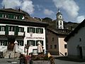 s Gmäindhuus und di refermierti Chile vo Sils Maria
 s Nietzsche-Huus z Sils Maria
 d Säilbaan uf Furtschellas ufe
 Engadyner Hüüser im Fexdaal


Weblink
- Website vo dr Gmäind Sils im Engadin/Segl
- Ottavio Clavuot: Sils im Engadin/Segl. In: Historisches Lexikon vo dr Schwiiz.
- Ottavio Clavuot: Fex. In: Historisches Lexikon vo dr Schwiiz.
Fuessnoote
Wikiwand - on
Seamless Wikipedia browsing. On steroids.
Remove ads