File:World_in_820.png
من ويكيبيديا، الموسوعة encyclopedia
حجم هذه المعاينة: 800 × 400 بكسل. البعدان الآخران: 320 × 160 بكسل | 640 × 320 بكسل.
الملف الأصلي (1٬200 × 600 بكسل حجم الملف: 42 كيلوبايت، نوع MIME: image/png)
| هذا ملف من ويكيميديا كومنز. معلومات من صفحة وصفه مبينة في الأسفل. كومنز مستودع ملفات ميديا ذو رخصة حرة. |
ملخص
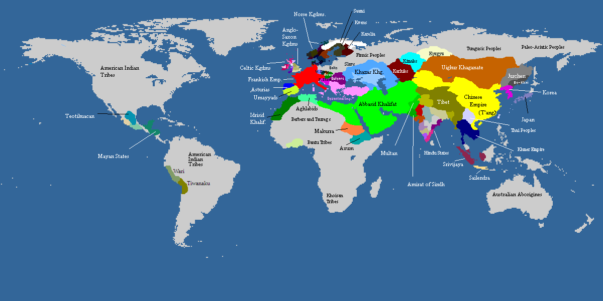
| الوصفWorld in 820.png |
Deutsch: Weltkarte, ca. um 820 n.Chr. Farbige Gebiete zeigen den Einfluss von grösseren Mächten in dieser Zeit, die Kontrolle über manche dieser Gebiete sind z.T. nur nominell vorhanden. Graue Gebiete waren entweder vorwiegend von Ureinwohnern besiedelt oder unbewohnt.
English: Map of the world, c. AD 820. Colored areas show the extent of influence for the major empires of the period; control over some areas may have been purely nominal. Gray areas showed areas that are mainly inhabited by Indigineous populations, or completely uninhabited.
한국어: 서기 820년의 세계지도입니다. 색깔이 있는 지역은 이 시대의 현존했던 왕국과 제국의 영향력을 보여주는 것입니다. 회색지역은 인디언이나 국가가 없던 지역이거나 혹은 사람이 살지 않은 곳입니다. |
||
| التاريخ | not stated | ||
| المصدر | from academic sources | ||
| المؤلف | multiple authors | ||
| إصدارات أخرى |
|

| Maps of world history | |
| BC | |
|
| |
| AD |
1 · 50 · 100 · 200 · 250 · 300 · 400 · 500 · 700 · 750 · 820 · 900 · 1200 · 1500 · 1556 · 1648 · 1700 · 1750 · 1815 · 1859 · 1871 · 1914 · 1935 · 1954 · 1989 · 2000 · |
|
Maps of colonization history | |
|
see also: Eastern Hemisphere only maps template (1300BC-1500AD) | |
| (this template: · view · discuss ) | |
.jpg)
._LOC_2001620596.jpg)

|
هذه historical map الصورة / الصورتان باستعمال رسومات متجهية ملفات رسوميات شعاعية.
It is recommended to name the SVG file "World in 820.svg" - then the template Vector version available (or Vva) does not need the new image name parameter.
|
ترخيص
| هذا الملفُّ مُرخَّص بموجب رخصة المشاع الإبداعي نسبة المُصنَّف إِلى مُؤَلِّفه - المشاركة بالمثل 3.0 العامة Subject to disclaimers. | ||
| ||
| تمت إضافة علامة الترخيص لهذا الملف كجزء من رخصة جنو للوثائق الحرة تحديث الترخيص.http://creativecommons.org/licenses/by-sa/3.0/CC BY-SA 3.0Creative Commons Attribution-Share Alike 3.0truetrue |

|
يسمح نسخ وتوزيع و/أو تعديل هذه الوثيقة تحت شروط رخصة جنو للوثائق الحرة، الإصدار 1.2 أو أي إصدار لاحق تنشره مؤسسة البرمجيات الحرة؛ دون أقسام ثابتة ودون نصوص أغلفة أمامية ودون نصوص أغلفة خلفية. نسخة من الرخصة تم تضمينها في القسم المسمى GNU Free Documentation License. Subject to disclaimers.http://www.gnu.org/copyleft/fdl.htmlGFDLGNU Free Documentation Licensetruetrue |
الشروحات
أضف شرحاً من سطر واحد لما يُمثِّله هذا الملف
العناصر المصورة في هذا الملف
يُصوِّر
تاريخ الملف
اضغط على زمن/تاريخ لرؤية الملف كما بدا في هذا الزمن.
| زمن/تاريخ | صورة مصغرة | الأبعاد | مستخدم | تعليق | |
|---|---|---|---|---|---|
| حالي | 10:06، 20 نوفمبر 2022 | | 1٬200 × 600 (42 كيلوبايت) | Roy17 | Reverted to version as of 15:56, 11 May 2009 (UTC) Commons:Overwriting existing files ✘ Major changes (e.g. a radical crop) |
| 12:52، 16 نوفمبر 2019 |  | 4٬974 × 2٬519 (629 كيلوبايت) | Anchuhu | [[Media:]] | |
| 12:44، 10 أغسطس 2016 |  | 646 × 408 (27 كيلوبايت) | Garam | Reverted to version as of 13:11, 11 July 2012 (UTC) | |
| 14:28، 14 ديسمبر 2013 |  | 1٬170 × 486 (40 كيلوبايت) | Billinghurst | Reverted to version as of 00:40, 7 June 2009, prior to expansion to other areas | |
| 13:11، 11 يوليو 2012 |  | 646 × 408 (27 كيلوبايت) | Runehelmet | updated | |
| 08:30، 11 أبريل 2011 |  | 644 × 408 (15 كيلوبايت) | Garam | Fix. (The northern area of Taedong River is Balhae territory. Now version border is Goryeo territory.) | |
| 09:21، 10 أبريل 2011 |  | 644 × 408 (15 كيلوبايت) | Garam | Fix the name (Goryeo - A.D. 918 ~ A.D. 1392, Silla - B.C. 57 ~ A.D. 935, Later Three Kingdoms - A.D. 892 ~ A.D. 936) | |
| 17:19، 19 مارس 2010 |  | 644 × 408 (10 كيلوبايت) | Aiyizo | compressed with pngout | |
| 19:29، 17 يناير 2010 |  | 644 × 408 (30 كيلوبايت) | Ecthelion83 | Reverted to version as of 19:28, 17 January 2010 | |
| 19:29، 17 يناير 2010 |  | 644 × 408 (30 كيلوبايت) | Ecthelion83 | Reverted to version as of 19:27, 17 January 2010 |
استخدام الملف
لا توجد صفحات تستخدم هذا الملف.
الاستخدام العالمي للملف
الويكيات الأخرى التالية تستخدم هذا الملف:
- الاستخدام في en.wikipedia.org
- الاستخدام في es.wikipedia.org