File:Map-Francophone_World.png
From Wikipedia, the free encyclopedia
ܠܦܦܐ ܫܪܫܝܐ (1,425 × 631 ܦܩܣܠ، ܥܓܪܐ ܕܠܦܦܐ: 39 KB، ܐܕܫܐ ܕ MIME: image/png)
This file is from Wikimedia Commons and may be used by other projects. The description on its file description page there is shown below.
ܦܣܝܩܬ̈ܐ
| DescriptionMap-Francophone World.png |
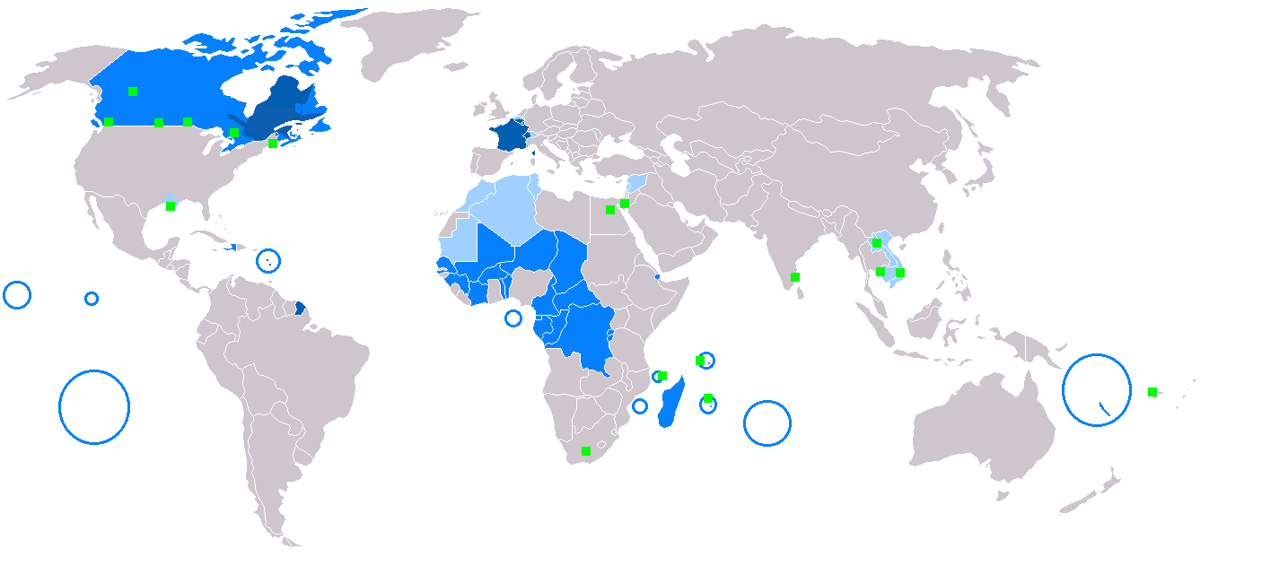
English: Map of Francophone world.
Français : Carte du monde où on parle le français.
Русский: Карта франкоязычного мира.
Nederlands: Het Frans in de wereld.
Suomi: Maailmankartta ranskaa puhuvista maista.
Українська: Мапа франкомовного світу.
日本語: フランス語圏の地図。
中文:说法语的人在世界上的分布情况
Čeština: Mapa frankofonního světa
|
| Caption InfoField | English:
Français :
Español:
Deutsch:
Русский:
العربية:
Slovenčina:
Čeština:
Esperanto:
Italiano:
Magyar:
Nederlands:
Norsk bokmål:
Polski:
Português:
Română:
Suomi:
Svenska:
Türkçe:
Українська:
中文:
日本語: |
| ܣܝܩܘܡܐ | |
| ܡܒܘܥܐ |
Incomplete This file was derived from: BlankMap-World.png: |
| ܣܝܘܡܐ |
|
ܦܣܣܐ
| Public domainPublic domainfalsefalse |
| This work has been released into the public domain by its author, Yug. This applies worldwide. In some countries this may not be legally possible; if so: |
Captions
Items portrayed in this file
depicts English
inception English
10 ܒܟܢܘܢ ܩܕܡ 2005
media type English
image/png
ܬܫܥܝܬܐ ܕܠܦܦܐ
Click on a date/time to view the file as it appeared at that time.
| ܣܝܩܘܡܐ/ܙܒܢܐ | ܨܘܪܬܐ ܙܥܘܪܬܐ | ܩܝܡ̈ܐ | ܡܦܠܚܢܐ | ܥܘܩܒܐ | |
|---|---|---|---|---|---|
| ܗܫܝܐ | 20:20, 9 ܒܐܕܪ 2018 | | 1,425 × 631 (39 KB) | Maphobbyist | South Sudan border |
| 12:30, 23 ܒܟܢܘܢ ܐܚܪܝ 2018 |  | 1,425 × 631 (39 KB) | Maphobbyist | Sticking to sources. French is not the majority mother language in Gabon and Ivory coast and in its capital cities. | |
| 13:22, 19 ܒܢܝܣܢ 2017 |  | 1,425 × 631 (39 KB) | Sorkiv | The French language has become native to Gabon and Côte d'Ivoire (Abidjan, Yamoussoukro). | |
| 12:53, 7 ܒܐܝܪ 2015 |  | 1,425 × 631 (39 KB) | Zorion | From Hearst (Ontario) to Abitibi, it's a french-speaking zone + Anticosti added + remouved a part of New-Brunswick + francophone in Alberta are located in the Noth-West + Aroostook County in US | |
| 17:52, 11 ܒܟܢܘܢ ܩܕܡ 2014 |  | 1,425 × 631 (56 KB) | Maphobbyist | In Syria French is a secondary non-official language. | |
| 16:57, 11 ܒܟܢܘܢ ܩܕܡ 2014 |  | 1,425 × 631 (49 KB) | Maphobbyist | In New Caledonia, French is the sole official language, but it is the mother language of a minority. | |
| 17:13, 6 ܒܐܕܪ 2008 |  | 1,425 × 631 (32 KB) | Arctic.gnome | French is administrative in Canada and a secondary language in Andorra. I also added PEI and Manitoulin Island to Canada, and Saint Pierre, Miquelon and Sable islands around the Newfoundland coast. | |
| 17:09, 6 ܒܐܕܪ 2008 |  | 1,425 × 631 (50 KB) | Arctic.gnome | Reverted to version as of 20:37, 22 January 2007 | |
| 17:08, 6 ܒܐܕܪ 2008 |  | 1,425 × 631 (32 KB) | Arctic.gnome | == Summary == Map of Francophone world. Map made from Image:BlankMap-World.png '''English''' legends: {{legend|#0c5eb1|native language}} {{legend|#0080ff|administrative language}} {{legend|#9fceff|secondary or non-official langua | |
| 20:37, 22 ܒܟܢܘܢ ܐܚܪܝ 2007 |  | 1,425 × 631 (50 KB) | IAMTHEEGGMAN | Updating actual World Map and Adding Montenegro. |
ܡܦܠܚܬܐ ܕܠܦܦܐ
ܠܝܬ ܦܐܬܐ ܕܐܣܪ ܠܗܢܐ ܠܦܦܐ.
ܡܦܠܚܢܘܬܐ ܓܘܢܝܬܐ ܕܠܦܦܐ
The following other wikis use this file:
- Usage on de.wikipedia.org
- Usage on en.wikipedia.org
- Usage on fr.wikipedia.org
- Usage on fr.wiktionary.org
- Usage on he.wikivoyage.org
- Usage on it.wikipedia.org
- Usage on it.wiktionary.org
- Usage on no.wiktionary.org
- Usage on zh-min-nan.wikipedia.org
ܓܠܝܬ̈ܐ ܕܡܝܛܐ
This file contains additional information, probably added from the digital camera or scanner used to create or digitize it.
If the file has been modified from its original state, some details may not fully reflect the modified file.
| Horizontal resolution | 37.8 dpc |
|---|---|
| Vertical resolution | 37.8 dpc |