File:East-Hem_476ad.jpg
From Wikipedia, the free encyclopedia
الصوره الاصليه (3,240 × 1,903 بكسل حجم الفايل: 754 كيلوبايت، نوع MIME: image/jpeg)
الملف دا من ويكيميديا كومنز و ممكن تستعمله المشاريع التانيه. الوصف بتاعه صفحة وصف الملف هناك معروض تحت..

|
هذه historical map الصورة / الصورتان باستعمال رسومات متجهية ملفات رسوميات شعاعية.
It is recommended to name the SVG file "East-Hem 476ad.svg" - then the template Vector version available (or Vva) does not need the new image name parameter.
|
 | الصُّور الموجودة في file رُفعت بصيغة JPEG مع أنها تحتوي عناصر بيانات غير مرتبطة بالصُّور الضَّوئِيَّة. يُمكِن تخزين هذه المَعلُومات بطريقةٍ أكثرَ فعاليَّةً باستعمال صيغة PNG أو SVG. ارفع نسخة بصيغة PNG أو SVG لو أمكن مِن غير التَّشوهات النَّاتِجة عن الضَّغط في نسخة JPEG. بعد إنجاز ذلك، سِم نسخة JPEG بقالب {{Superseded|اسم الصورة الجديدة.الصيغة}} ثُمَّ أزل هذا القالب. لا يُستعمل هذا القالب مع الصُّور الضَّوئيَّة أو الصُّور المَمسُوحة ضوئيَّاً. للمزيد من المعلومات انظر قالب {{BadJPEG}}. |  |
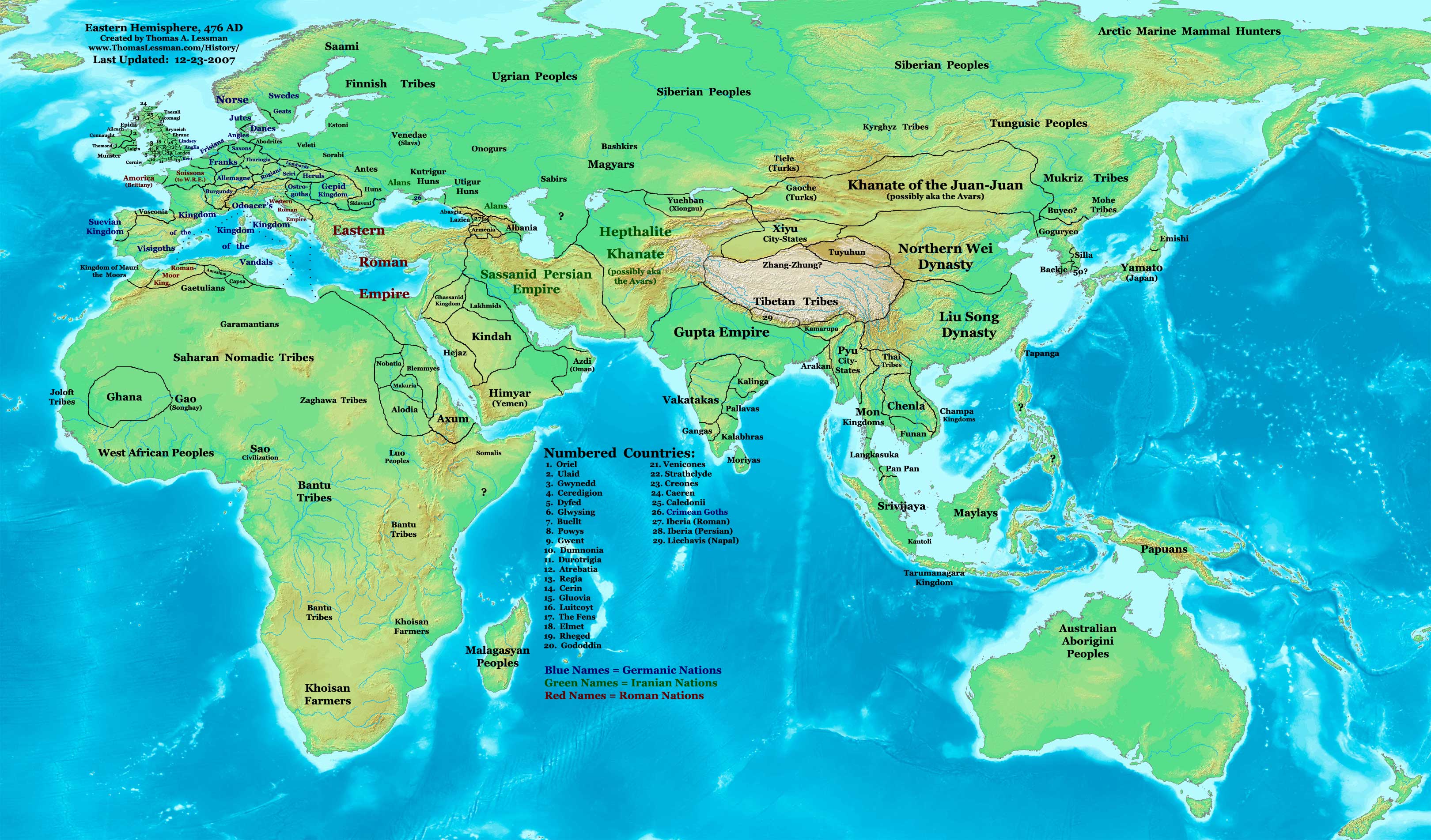
| وصفEast-Hem 476ad.jpg | Eastern Hemisphere in 476 AD. | |||
| مصدر | self-made (For reference information, see the Map Source References section below.) | |||
| مؤلف | Thomas Lessman (Contact!) | |||
| سماح (إعادة استخدام الملف ده) |
أنا، صاحب حقوق التأليف والنشر لهذا العمل، أنشر هذا العمل تحت الرخصة التالية: الملف ده مترخص حسب رخصة المشاع الإبداعى نسبة المصنف للى مألفه - المشاركة بالمثل 3.0 العامه
|
|||
| إصدارات أخرى |
|
.jpg)
المحتويات
Map Summary
Original Source URL: http://www.thomaslessman.com/History/images/East-Hem_476ad.jpg.
This map of the Eastern Hemisphere in 476 AD was created by Thomas Lessman, based on information from the sources listed below. This map is free for educational use (see Permission info above). When using this map, please mention that it is available for free at www.WorldHistoryMaps.info.
Map Source References
- Remember, sources often conflict with each other. This map is only as accurate as the information that is available to me. To report any errors or to help further this work, please click here, or email Thomas Lessman at talessman@yis.us
References for information contained in this map:
1. The DK Atlas of World History, 2000 Edition; map of The World in 500 CE, (Pages 50-51) was used for information on several borders in this map.
2. Borders of Europe are mostly derived from the Euratlas.com map of Europe in 500 AD.
- a - Borders of Britain are derived from the "EarlyBritishKingdoms.com", map of map Britain in 475 AD.
3. Borders of Asia are derived mostly from the following sources:
- a - various Wikipedia articles and Google history map searches.
- (More info will be added soon)
4. Some information is derived from Wikimedia's map of The world in 500 CE, created by User:Javierfv1212.
5. Much of the information in this map was cross-checked with Bruce Gordon's Regnal Chronologies.
Other Historical Maps by Thomas Lessman
| Maps of the eastern hemisphere showing history
Bold dates are available on Wikimedia or Wikipedia. | ||
| Primeval | ||
| Ancient
|
·| 600 BC | 550 BC | 527 BC | 500 BC |
400 BC | ·| 1 AD | 50 AD | 100 AD | 200 AD | 300 AD | | |
| Medieval |
·| 500 AD | 565 AD | 600 AD | 700 AD | | |
| Modern |
·| 1500 AD | · * For historical maps of the whole world, | |
| history links talk edit view | ||
سجلُّ الرَّفع الأصيل
- 2007-12-23 11:36 Talessman 3240×1903×8 (771644 bytes) Added numbered legend. Added more info for Manchuria, central Asia, Indonesia, Africa, and British Isles.
- 2007-11-06 22:07 Talessman 3240×1903×8 (718060 bytes) Updated borders for Sudan and Arabia.
- 2007-10-30 00:25 Talessman 3240×1903×8 (718905 bytes) Updated info on far eastern islands, Japan, Indonesia, etc.
- 2007-09-26 15:42 Talessman 2880×1692×8 (572882 bytes) Author: Thomas A. Lessman. Source URL: http://www.ThomasLessman.com/History/images/East-Hem_476ad.jpg. Image was created by me (Thomas Lessman) based on historical information located on Wikipedia, as well as information from maps located in Wikipedia and
- 2007-09-12 21:08 Talessman 2942×1728×8 (578540 bytes) Reverted to version as of 20:43, 12 September 2007
- 2007-09-12 20:44 Talessman 2942×1728×8 (578540 bytes) Reverted to version as of 19:32, 12 September 2007
- 2007-09-12 20:43 Talessman 2942×1728×8 (578540 bytes) Author: Thomas A. Lessman. Source URL: http://www.ThomasLessman.com/History/images/East-Hem_476ad.jpg. Image was created by me (Thomas Lessman) based on historical information located on Wikipedia, as well as information from maps located in Wikipedia and
- 2007-09-12 19:32 Talessman 2942×1728×8 (578540 bytes) Author: Thomas A. Lessman. Source URL: http://www.ThomasLessman.com/History/images/East-Hem_476ad.jpg. Image was created by me (Thomas Lessman) based on historical information located on Wikipedia, as well as information from maps located in Wikipedia and
- 2007-08-23 19:15 Talessman 1973×1159×8 (2352602 bytes) Reverted to earlier revision
- 2007-08-23 19:15 Talessman 1973×1159×8 (2373060 bytes) Author: Thomas A. Lessman. Source URL: http://www.ThomasLessman.com/History/images/East-Hem_600ad.jpg. Image was created by me (Thomas Lessman) based on historical information located on Wikipedia, as well as information from maps located in Wikipedia and
- 2007-08-23 19:12 Talessman 1973×1159×8 (2373060 bytes) Author: Thomas A. Lessman. Source URL: http://www.ThomasLessman.com/History/images/East-Hem_600ad.jpg. Image was created by me (Thomas Lessman) based on historical information located on Wikipedia, as well as information from maps located in Wikipedia and
- 2007-07-21 20:15 Talessman 1973×1159×8 (2352602 bytes) Author: Thomas A. Lessman. Source URL: http://www.ThomasLessman.com/History/images/East-Hem_476ad.jpg. Image was created by me (Thomas Lessman) based on historical information located on Wikipedia, as well as information from maps located in Wikipedia and
الشروحات
العناصر المصورة في هذا الملف
يُصوِّر العربية
تاريخ الفايل
اضغط على الساعه/التاريخ علشان تشوف الفايل زى ما كان فى الوقت ده.
| الساعه / التاريخ | صورة صغيرة | ابعاد | يوزر | تعليق | |
|---|---|---|---|---|---|
| دلوقتي | 14:32، 18 ابريل 2008 | | 3,240 × 1,903 (754 كيلوبايت) | Rottweiler | {{Information |Description=== Summary == Author: Thomas A. Lessman. Source URL: http://www.ThomasLessman.com/History/images/East-Hem_476ad.jpg. Image was created by Thomas Lessman based on historical information located in sources listed below. This map i |
استخدام الفايل
مافيش صفحات بتوصل للفايل ده.
استخدام الملف العام
الويكيات التانيه دى بتستخدم الفايل ده:
- الاستخدام ف de.wikipedia.org
- الاستخدام ف en.wikipedia.org
- الاستخدام ف id.wikipedia.org
- الاستخدام ف jv.wikipedia.org
- الاستخدام ف rue.wikipedia.org
- الاستخدام ف ru.wikipedia.org
- الاستخدام ف sv.wikipedia.org
بيانات ميتا
الملف ده فيه معلومات إضافيه، غالبا ما تكون أضيفت من الديجيتال كاميرا أو السكانر ح الضوئى المستخدم فى نقل الملف للكومبيوتر.
إذا كان الملف اتعدل عن حالته الأصلية، فبعض التفاصيل مش ها تعبر عن الملف المعدل.
| _error | 0 |
|---|