Ficheru:Livingston-Island-Map-2010-15.png
From Wikipedia, the free encyclopedia
Tamañu d'esta previsualización: 799 × 600 pixels. Otres resoluciones: 320 × 240 pixels | 640 × 480 pixels | 1023 × 768 pixels | 1280 × 961 pixels | 2560 × 1922 pixels | 5337 × 4006 pixels.
Ficheru orixinal (5337 × 4006 píxels, tamañu de ficheru: 9,65 MB, triba MIME: image/png)
Esti ficheru ye de Wikimedia Commons y puen usalu otros proyeutos. La descripción de la páxina de descripción del ficheru s'amuesa darréu.
Resume
| DescripciónLivingston-Island-Map-2010-15.png |
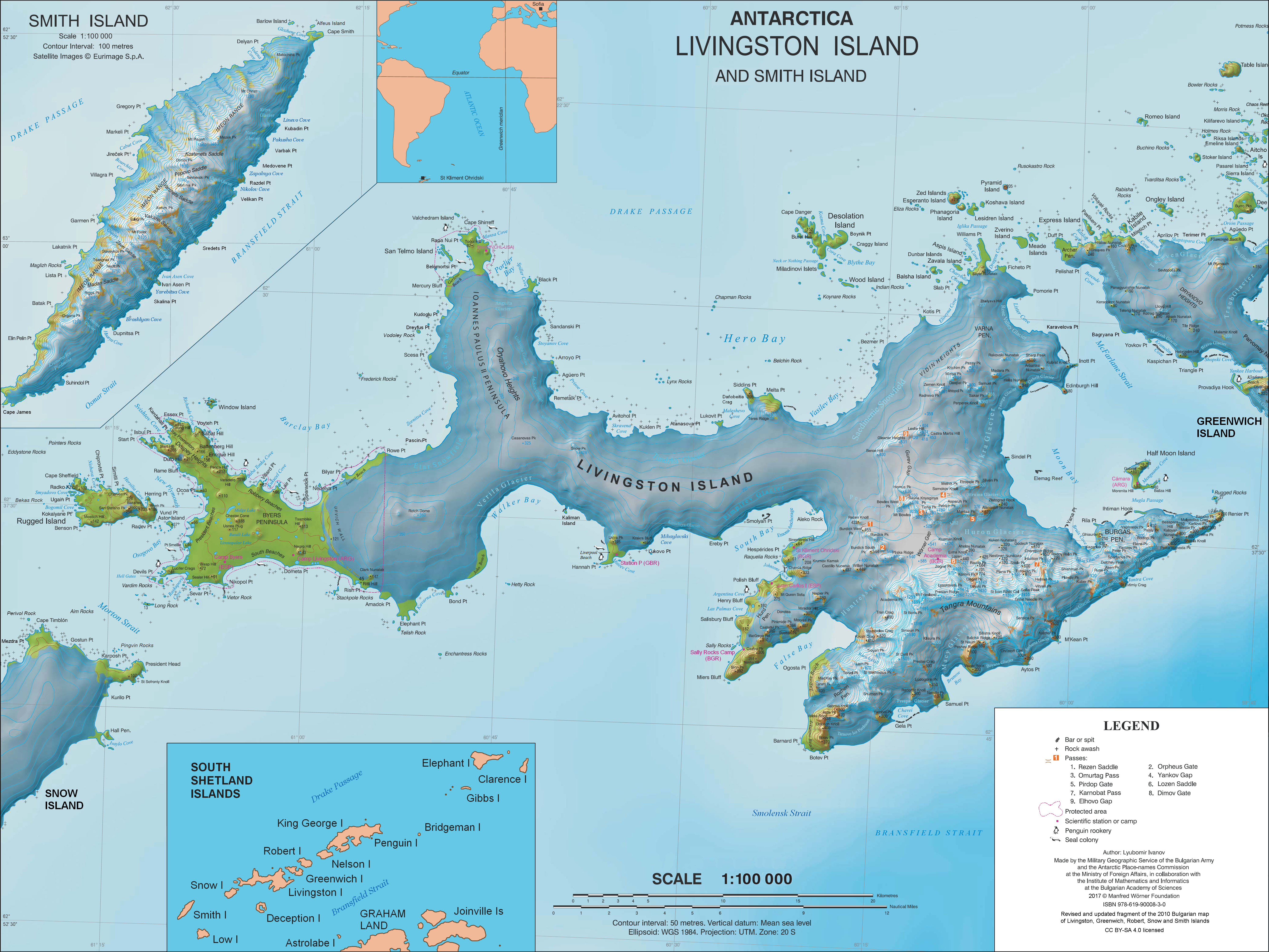
English: L.L. Ivanov. Antarctica: Livingston Island and Smith Island. Scale 1:100000 topographic map. Manfred Wörner Foundation, 2017. ISBN 978-619-90008-3-0 |
| Data | |
| Fonte | Trabayu propiu |
| Autor | Apcbg |
| Permisu (Cómo reutilizar esti ficheru) |
Published by the Manfred Wörner Foundation under the Creative Commons Attribution ShareAlike 4.0 license. |
| Otres versiones | File:Livingston-Island-Map-2010.jpg, an earlier version |
Llicencia
Yo, el titular de los drechos d'autor d'esta obra, la espublizo baxo la siguiente llicencia:
Este archivo está disponible bajo la licencia Creative Commons Attribution-Share Alike 4.0 International.
- Ye llibre:
- pa compartir – pa copiar, distribuir y comunicar públicamente la obra
- pa remezclar – p'adautar la obra
- Baxo les condiciones siguientes:
- reconocimientu – Tienes de dar el créitu apropiáu, apurrir un enllaz a la llicencia ya indicar si realizasti dalgún cambéu. Puedes faelo de cualquier mou razonable ,pero non de manera que suxera l'encontu del autor pa ti o pal usu que faigas.
- compartir igual – Si entemeces, tresformes o te bases nesti material, tienes de distribuir les tos contribuciones baxo la mesma llicencia o una compatible cola orixinal.
Pies
Añade una explicación corta acerca de lo que representa este archivo
Topographic map of Livingston Island and Smith Island, Antarctica
Elementos representados en este archivo
representa a
Algún valor sin elemento de Wikidata
CC BY-SA 4.0 español
31 mar 2017
tipo de archivo español
image/png
Historial del ficheru
Calca nuna fecha/hora pa ver el ficheru como taba daquella.
(lo más nuevo | lo más antiguo) Ver (10 siguientes | 10 anteriores) (10 | 20 | 50 | 100 | 250 | 500)
| Data/Hora | Miniatura | Dimensiones | Usuariu | Comentariu | |
|---|---|---|---|---|---|
| actual | 10:28 2 abr 2021 | | 5337 × 4006 (9,65 MB) | Apcbg | update |
| 13:21 27 xun 2019 |  | 5337 × 4006 (9,65 MB) | Apcbg | minor update | |
| 12:21 23 may 2019 |  | 5337 × 4006 (9,65 MB) | Apcbg | update | |
| 08:22 19 mar 2019 |  | 5337 × 4006 (9,65 MB) | Apcbg | minor update | |
| 21:14 9 feb 2019 |  | 5337 × 4006 (9,66 MB) | Apcbg | Update | |
| 15:35 5 feb 2019 |  | 5337 × 4006 (9,66 MB) | Apcbg | Minor | |
| 19:20 2 feb 2019 |  | 5337 × 4006 (9,66 MB) | Apcbg | Update | |
| 06:44 9 ago 2018 |  | 5337 × 4006 (9,66 MB) | Apcbg | Update | |
| 06:17 8 ago 2018 |  | 5337 × 4006 (9,66 MB) | Apcbg | Update | |
| 11:38 31 mar 2017 |  | 5337 × 4006 (10,92 MB) | Apcbg | Updated topography and toponymy |
(lo más nuevo | lo más antiguo) Ver (10 siguientes | 10 anteriores) (10 | 20 | 50 | 100 | 250 | 500)
Usu del ficheru
La páxina siguiente usa esti ficheru:
Usu global del ficheru
Estes otres wikis usen esti ficheru:
- Usu en ar.wikipedia.org
- Usu en az.wikipedia.org
- Usu en bg.wikipedia.org
- Свети Климент Охридски (база)
- Ливингстън (остров)
- Тангра (планина)
- Монтана (връх)
- Академия (връх)
- Айтос (нос)
- Авитохол (нос)
- Цариград (връх)
- Лясковец (връх)
- Фрисланд (връх)
- Видински възвишения
- Куцото куче
- Свети Борис (връх)
- Симеон (връх)
- Варна (полуостров)
- Свети Иван Рилски (рид)
- Потребител:Dafosaddikk/Скала Белчин
- Скала Белчин
- Usu en ca.wikipedia.org
- Usu en ceb.wikipedia.org
- Usu en de.wikipedia.org
- Livingston-Insel
- Table Island (Südliche Shetlandinseln)
- Barclay Bay
- Kap Shirreff
- Johannes-Paul-II.-Halbinsel
- Hero Bay
- Desolation Island (Südliche Shetlandinseln)
- Burdick Peak
- Black Point (Livingston-Insel)
- Blythe Bay
- Hemus Peak
- Leslie Hill (Livingston-Insel)
- Brunow Bay
- Bravo-Gletscher
- McFarlane Strait
- Renier Point
- Burdick South Peak
- Burdick West Peak
- Willan-Nunatak
- Plíska Ridge
- Rotch Dome
- Cora Cove
- Craggy Island (Südliche Shetlandinseln)
- Eddystone Rocks (Südliche Shetlandinseln)
Ver más usos globales d'esti ficheru.
Metadatos
Esti ficheru contien otra información, probablemente añadida pola cámara dixital o l'escáner usaos pa crealu o dixitalizalu.
Si'l ficheru se camudó dende'l so estáu orixinal, seique dalgunos detalles nun se reflexen completamente nel ficheru camudáu.
| Resolución horizontal | 37,8 ppc |
|---|---|
| Resolución vertical | 37,8 ppc |
| Software usáu |
|