Fayl:Almohads1200.png
From Wikipedia, the free encyclopedia
Sınaq göstərişi ölçüsü: 800 × 497 piksel. Digər ölçülər: 320 × 199 piksel | 640 × 398 piksel | 846 × 526 piksel.
Faylın orijinalı (846 × 526 piksel, fayl həcmi: 19 KB, MIME növü: image/png)
| Bu fayl "Vikimedia Commons"dadır və digər layihələrdə istifadə edilə bilər. |
 |
Faylın təsvir səhifəsinə get |

|
This historical map image could be re-created using vector graphics as an SVG file. This has several advantages; see Commons:Media for cleanup for more information. If an SVG form of this image is available, please upload it and afterwards replace this template with
{{vector version available|new image name}}.
It is recommended to name the SVG file “Almohads1200.svg”—then the template Vector version available (or Vva) does not need the new image name parameter. |
Xülasə
| İzahAlmohads1200.png |
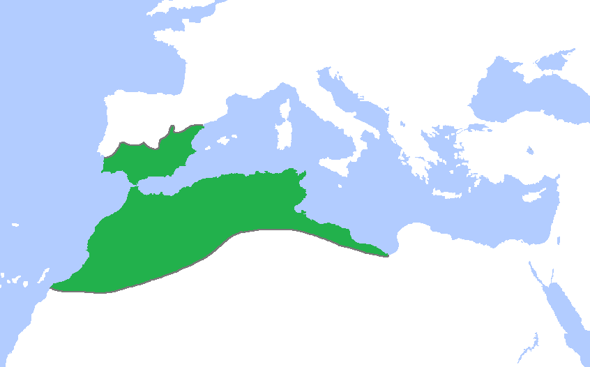
English: Locator map of the Almohad dynasty at its greatest extent, c. 1200.
(Partially based on Atlas of World History (2007) - The World 1000-1200, map) |
| Tarix | |
| Mənbə | Öz işi |
| Müəllif | Gabagool |
Lisenziya
I, the copyright holder of this work, hereby publish it under the following license:
This file is licensed under the Creative Commons Attribution 3.0 Unported license.
- Azadsınız:
- paylaşmaq – əsəri köçürmək, paylamaq və ötürmək üçün
- remiks etmək – əsəri adaptasiya etmək
- Aşağıdakı şərtlərə riayət etməklə:
- istinad – Müvafiq kredit verməlisiniz, lisenziyaya bir keçid verməlisiniz və dəyişikliklərin olub olmadığını bildirməlisiniz. Bunu hər hansı bir ağlabatan şəkildə edə bilərsiniz, ancaq lisenziyalaşdırıcının sizi və ya istifadənizi təsdiqləməsini təklif edən bir şəkildə deyil.
Captions
Add a one-line explanation of what this file represents
The dominion of the Almohad Caliphate at its greatest extent, c. 1200 CE
Items portrayed in this file
təsvir edir
copyright status ingilis
copyrighted ingilis
22 aprel 2009
source of file ingilis
original creation by uploader ingilis
media type ingilis
image/png
checksum ingilis
62f7cf2b5b5e2b2a7f34b661b837b7e9a189f09f
data size ingilis
19.206 Bayt
526 piksel
846 piksel
Faylın tarixçəsi
Faylın əvvəlki versiyasını görmək üçün gün/tarix bölməsindəki tarixlərə klikləyin.
| Tarix/Vaxt | Kiçik şəkil | Ölçülər | İstifadəçi | Şərh | |
|---|---|---|---|---|---|
| indiki | 19:28, 1 iyun 2009 | | 846 × 526 (19 KB) | Gabagool | further cropped |
| 13:01, 23 may 2009 |  | 1.114 × 674 (29 KB) | Gabagool | cropped | |
| 15:48, 22 aprel 2009 |  | 1.481 × 902 (46 KB) | Gabagool | {{Information |Description={{en|1=Locator map of the Almohad dynasty at its greatest extent, c. 1200. (Partially based on ''Atlas of World History'' (2007) - The World 1000-1200, map)}} |Source=Own work by uploader |Author=Gabagool / Ja |
Fayl keçidləri
Aşağıdakı 2 səhifə bu faylı istifadə edir:
Faylın qlobal istifadəsi
Bu fayl aşağıdakı vikilərdə istifadə olunur:
- als.wikipedia.org layihəsində istifadəsi
- an.wikipedia.org layihəsində istifadəsi
- ast.wikipedia.org layihəsində istifadəsi
- bar.wikipedia.org layihəsində istifadəsi
- ba.wikipedia.org layihəsində istifadəsi
- be.wikipedia.org layihəsində istifadəsi
- bn.wikipedia.org layihəsində istifadəsi
- ckb.wikipedia.org layihəsində istifadəsi
- da.wikipedia.org layihəsində istifadəsi
- de.wikipedia.org layihəsində istifadəsi
- en.wikipedia.org layihəsində istifadəsi
- es.wikipedia.org layihəsində istifadəsi
- eu.wikipedia.org layihəsində istifadəsi
- fa.wikipedia.org layihəsində istifadəsi
- fi.wikipedia.org layihəsində istifadəsi
- fr.wikipedia.org layihəsində istifadəsi
- hy.wikipedia.org layihəsində istifadəsi
- id.wikipedia.org layihəsində istifadəsi
- ja.wikipedia.org layihəsində istifadəsi
- mk.wikipedia.org layihəsində istifadəsi
- ms.wikipedia.org layihəsində istifadəsi
- no.wikipedia.org layihəsində istifadəsi
- pl.wikipedia.org layihəsində istifadəsi
- pnb.wikipedia.org layihəsində istifadəsi
- pt.wikipedia.org layihəsində istifadəsi
Bu faylın qlobal istifadəsinə baxın.