Ladawan:Barents_Sea_map.png
From Wikipedia, the free encyclopedia
Pakadakula kan pasirip na ini: 657 × 600 na pixel. Ibang mga resolusyon: 263 × 240 na pixel | 526 × 480 na pixel | 841 × 768 na pixel | 1,187 × 1,084 na pixel.
Orihinal na file (1,187 × 1,084 na pixel, pakadakula: 654 KB, tipo nin MIME: image/png)
An sagunson na ini naggikan sa Wikimedia Commons asin mapuwedeng gamiton kan ibang mga proyekto. Pinapahiling tabi sa ibaba an deskripsyon na yaon sa sagunsong deskripsyon kan pahina.
Hali sa Wikimedia Commons an file na ito asin pwedeng magamit sa ibang proyekto. Mahihiling sa baba an paglaladawan sa pahina kan paglaladawan kan file kaini duman.
Sumaryo
| PagladawanBarents Sea map.png |
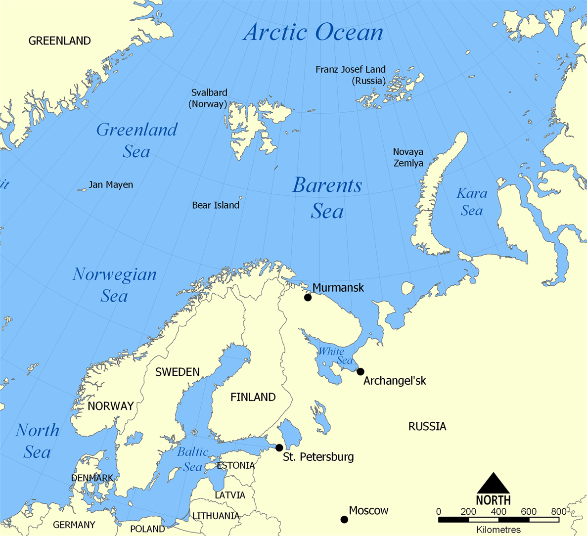
English: The location of the Barents Sea north of Russia and Norway, and the surrounding seas and islands. Also includes political borders with their corresponding nation-states listed. |
| Petsa | |
| Pinagkunan | Sadiring gibo |
| Kagsurat | NormanEinstein |
| Other versions |
[baguhon]
|


Paglisensya
I, the copyright holder of this work, hereby publish it under the following licenses:

|
Tinutugutan an pagkopya, pagpanao, asin/o pagbago sa dokumentong ini sa irarom kan mga termino kan GNU Free Documentation License, Bersyon 1.2 o dawa anong mas bagong bersyon na naipublikar kan Free Software Foundation; na mayong paburubagong seksyon, mayong teksto sa front-cover, asin walang teksto sa back-cover. Igwang nakalaag na kopya kan lisensya sa seksyon na may titulong GNU Free Documentation License.http://www.gnu.org/copyleft/fdl.htmlGFDLGNU Free Documentation Licensetruetrue |
| Nakalisensya an file na ini sa irarom kan lisensyang Creative Commons Attribution-Share Alike 3.0 Unported. | ||
| ||
| This licensing tag was added to this file as part of the GFDL licensing update.http://creativecommons.org/licenses/by-sa/3.0/CC BY-SA 3.0Creative Commons Attribution-Share Alike 3.0truetrue |
Pwede kang makapili nin lisensya mo.
Captions
Add a one-line explanation of what this file represents
The location of the Barents Sea
Barents Sea
Items portrayed in this file
depicts English
creator English
some value
copyright status English
copyrighted English
source of file English
original creation by uploader English
inception English
25 Nobyembre 2005
media type English
image/png
checksum English
f7a5ee6d4b4514fe0c001142a4b0f0bf17f69b6f
data size English
669,295 byte
height English
1,084 pixel
width English
1,187 pixel
Kasaysayan kan file
Pinduton an sarong petsa/oras para mahiling ng file sa puntong idto.
| Petsa/Oras | Thumbnail | Sukol | Paragamit | Komento | |
|---|---|---|---|---|---|
| presente | 20:52, 29 Marso 2012 | | 1,187 × 1,084 (654 KB) | Ras67 | cropped |
| 06:11, 5 Pebrero 2006 |  | 1,200 × 1,098 (680 KB) | Berkut~commonswiki | pngout-ed (13% file size reduction) | |
| 16:40, 25 Nobyembre 2005 |  | 1,200 × 1,098 (781 KB) | NormanEinstein | This map shows the location of the Barents Sea north of Russia and Norway, and the surrounding seas and islands. Created by NormanEinstein, November 25, 2005. {{GFDL-self}} Category:Maps of seas |
Paggamit sa file
Ginagamit kan minasunod na pahina an file na ini:
Pankinaban na paggamit sa file
Ginagamit kan mga minasunod na wiki an file na ini:
- Paggamit sa af.wikipedia.org
- Paggamit sa ar.wikipedia.org
- Paggamit sa arz.wikipedia.org
- Paggamit sa ast.wikipedia.org
- Paggamit sa azb.wikipedia.org
- Paggamit sa be-tarask.wikipedia.org
- Paggamit sa bg.wikipedia.org
- Paggamit sa bn.wikipedia.org
- Paggamit sa bs.wikipedia.org
- Paggamit sa ca.wikipedia.org
- Paggamit sa cs.wikipedia.org
- Paggamit sa cs.wikinews.org
- Paggamit sa da.wikipedia.org
- Paggamit sa de.wiktionary.org
- Paggamit sa el.wikipedia.org
- Paggamit sa en.wikipedia.org
- Barents Sea
- User:NormanEinstein/gallery
- Keith Jessop
- Convoy PQ 18
- Fishing industry in Russia
- Operation Fritham
- List of Russian explorers
- Convoy PQ 12
- Convoy PQ 8
- Arctic naval operations of World War II
- Convoy QP 14
- List of oil and gas fields of the Barents Sea
- Operation Orator
- Operation Gearbox
- Operation Gearbox II
- Atlantification of the Arctic
- Paggamit sa en.wikisource.org
- Paggamit sa en.wiktionary.org
- Paggamit sa eo.wikipedia.org
- Paggamit sa es.wikipedia.org
- Paggamit sa eu.wikipedia.org
- Paggamit sa fa.wikipedia.org
- Paggamit sa fi.wikipedia.org
- Paggamit sa fo.wikipedia.org
- Paggamit sa fr.wikipedia.org
- Paggamit sa fr.wikinews.org
- Paggamit sa he.wikipedia.org
- Paggamit sa hi.wikipedia.org
- Paggamit sa hu.wiktionary.org
Hilingon an kadagdagan na pankinaban na paggamit sa file na ini.