File:East-Hem_476ad.jpg
From Wikipedia, the free encyclopedia
Izvorna datoteka (3.240 × 1.903 piksela, veličina datoteke: 754 KB, MIME tip: image/jpeg)
| Ova datoteka je s Wikimedia Commonsa. Opis s njene stranice opisa datoteke prikazan je ispod. Commons je skladište slobodnih medija i datoteka za sve projekte fondacije Wikimedia. Možete i Vi pomoći. |

|
This historical map image could be re-created using vector graphics as an SVG file. This has several advantages; see Commons:Media for cleanup for more information. If an SVG form of this image is available, please upload it and afterwards replace this template with
{{vector version available|new image name}}.
It is recommended to name the SVG file “East-Hem 476ad.svg”—then the template Vector version available (or Vva) does not need the new image name parameter. |
 | This historical map image was uploaded in the JPEG format even though it consists of non-photographic data. This information could be stored more efficiently or accurately in the PNG or SVG format. If possible, please upload a PNG or SVG version of this image without compression artifacts, derived from a non-JPEG source (or with existing artifacts removed). After doing so, please tag the JPEG version with {{Superseded|NewImage.ext}} and remove this tag. This tag should not be applied to photographs or scans. If this image is a diagram or other image suitable for vectorisation, please tag this image with {{Convert to SVG}} instead of {{BadJPEG}}. If not suitable for vectorisation, use {{Convert to PNG}}. For more information, see {{BadJPEG}}. |  |
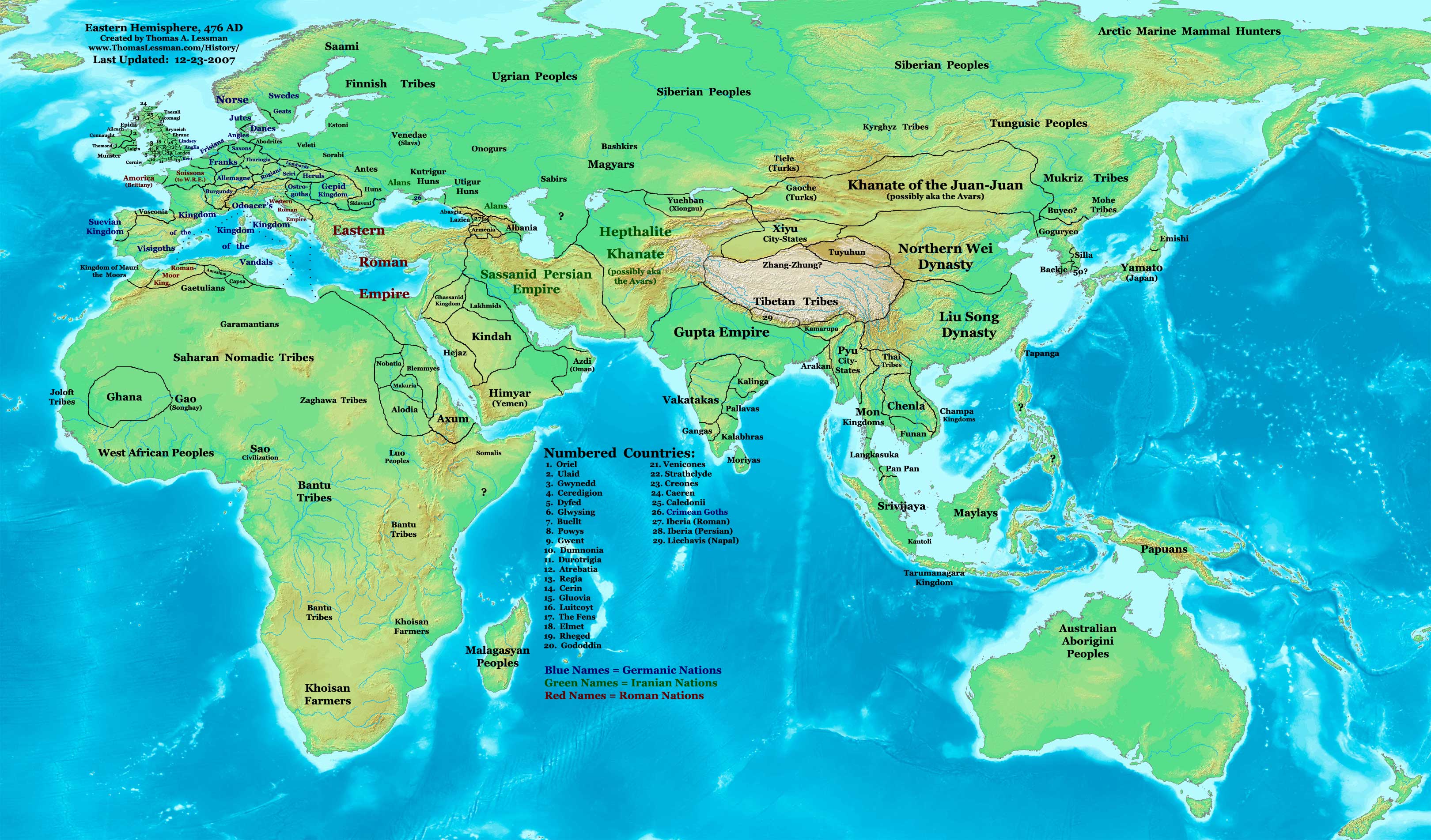
| OpisEast-Hem 476ad.jpg | Eastern Hemisphere in 476 AD. | |||
| Izvor | self-made (For reference information, see the Map Source References section below.) | |||
| Autor | Thomas Lessman (Contact!) | |||
| Dopuštenje (Naknadno korištenje ove datoteke) |
Ja, vlasnik autorskog prava ovog djela, ovdje ga objavljujem pod sljedećom licencom: Ova datoteka je licencirana pod Creative Commons Attribution-Share Alike 3.0 neportiranom licencom.
|
|||
| Ostale verzije |
|
.jpg)
Sadržaj
Map Summary
Original Source URL: http://www.thomaslessman.com/History/images/East-Hem_476ad.jpg.
This map of the Eastern Hemisphere in 476 AD was created by Thomas Lessman, based on information from the sources listed below. This map is free for educational use (see Permission info above). When using this map, please mention that it is available for free at www.WorldHistoryMaps.info.
Map Source References
- Remember, sources often conflict with each other. This map is only as accurate as the information that is available to me. To report any errors or to help further this work, please click here, or email Thomas Lessman at talessman@yis.us
References for information contained in this map:
1. The DK Atlas of World History, 2000 Edition; map of The World in 500 CE, (Pages 50-51) was used for information on several borders in this map.
2. Borders of Europe are mostly derived from the Euratlas.com map of Europe in 500 AD.
- a - Borders of Britain are derived from the "EarlyBritishKingdoms.com", map of map Britain in 475 AD.
3. Borders of Asia are derived mostly from the following sources:
- a - various Wikipedia articles and Google history map searches.
- (More info will be added soon)
4. Some information is derived from Wikimedia's map of The world in 500 CE, created by User:Javierfv1212.
5. Much of the information in this map was cross-checked with Bruce Gordon's Regnal Chronologies.
Other Historical Maps by Thomas Lessman
| Maps of the eastern hemisphere showing history
Bold dates are available on Wikimedia or Wikipedia. | ||
| Primeval | ||
| Ancient
|
·| 600 BC | 550 BC | 527 BC | 500 BC |
400 BC | ·| 1 AD | 50 AD | 100 AD | 200 AD | 300 AD | | |
| Medieval |
·| 500 AD | 565 AD | 600 AD | 700 AD | | |
| Modern |
·| 1500 AD | · * For historical maps of the whole world, | |
| history links talk edit view | ||
Originalni zapisnik postavljanja
- 2007-12-23 11:36 Talessman 3240×1903×8 (771644 bytes) Added numbered legend. Added more info for Manchuria, central Asia, Indonesia, Africa, and British Isles.
- 2007-11-06 22:07 Talessman 3240×1903×8 (718060 bytes) Updated borders for Sudan and Arabia.
- 2007-10-30 00:25 Talessman 3240×1903×8 (718905 bytes) Updated info on far eastern islands, Japan, Indonesia, etc.
- 2007-09-26 15:42 Talessman 2880×1692×8 (572882 bytes) Author: Thomas A. Lessman. Source URL: http://www.ThomasLessman.com/History/images/East-Hem_476ad.jpg. Image was created by me (Thomas Lessman) based on historical information located on Wikipedia, as well as information from maps located in Wikipedia and
- 2007-09-12 21:08 Talessman 2942×1728×8 (578540 bytes) Reverted to version as of 20:43, 12 September 2007
- 2007-09-12 20:44 Talessman 2942×1728×8 (578540 bytes) Reverted to version as of 19:32, 12 September 2007
- 2007-09-12 20:43 Talessman 2942×1728×8 (578540 bytes) Author: Thomas A. Lessman. Source URL: http://www.ThomasLessman.com/History/images/East-Hem_476ad.jpg. Image was created by me (Thomas Lessman) based on historical information located on Wikipedia, as well as information from maps located in Wikipedia and
- 2007-09-12 19:32 Talessman 2942×1728×8 (578540 bytes) Author: Thomas A. Lessman. Source URL: http://www.ThomasLessman.com/History/images/East-Hem_476ad.jpg. Image was created by me (Thomas Lessman) based on historical information located on Wikipedia, as well as information from maps located in Wikipedia and
- 2007-08-23 19:15 Talessman 1973×1159×8 (2352602 bytes) Reverted to earlier revision
- 2007-08-23 19:15 Talessman 1973×1159×8 (2373060 bytes) Author: Thomas A. Lessman. Source URL: http://www.ThomasLessman.com/History/images/East-Hem_600ad.jpg. Image was created by me (Thomas Lessman) based on historical information located on Wikipedia, as well as information from maps located in Wikipedia and
- 2007-08-23 19:12 Talessman 1973×1159×8 (2373060 bytes) Author: Thomas A. Lessman. Source URL: http://www.ThomasLessman.com/History/images/East-Hem_600ad.jpg. Image was created by me (Thomas Lessman) based on historical information located on Wikipedia, as well as information from maps located in Wikipedia and
- 2007-07-21 20:15 Talessman 1973×1159×8 (2352602 bytes) Author: Thomas A. Lessman. Source URL: http://www.ThomasLessman.com/History/images/East-Hem_476ad.jpg. Image was created by me (Thomas Lessman) based on historical information located on Wikipedia, as well as information from maps located in Wikipedia and
Captions
Items portrayed in this file
prikazuje
Historija datoteke
Kliknite na datum/vrijeme da vidite verziju datoteke iz tog vremena.
| Datum/vrijeme | Smanjeni pregled | Dimenzije | Korisnik | Komentar | |
|---|---|---|---|---|---|
| trenutno | 16:32, 18 april 2008 | | 3.240 × 1.903 (754 KB) | Rottweiler | {{Information |Description=== Summary == Author: Thomas A. Lessman. Source URL: http://www.ThomasLessman.com/History/images/East-Hem_476ad.jpg. Image was created by Thomas Lessman based on historical information located in sources listed below. This map i |
Upotreba datoteke
Nema stranica koje koriste ovu datoteku.
Globalna upotreba datoteke
Sljedeći wikiji koriste ovu datoteku:
- Upotreba na de.wikipedia.org
- Upotreba na en.wikipedia.org
- Upotreba na id.wikipedia.org
- Upotreba na jv.wikipedia.org
- Upotreba na rue.wikipedia.org
- Upotreba na ru.wikipedia.org
- Upotreba na sv.wikipedia.org
Metapodaci
Ova datoteka sadržava dodatne podatke koje je vjerovatno dodala digitalna kamera ili skener u procesu snimanja, odnosno digitalizacije. Ako je datoteka mijenjana, podaci možda nisu u skladu sa stvarnim stanjem.
| _error | 0 |
|---|