File:Срем.png
From Wikipedia, the free encyclopedia
Mida d'aquesta previsualització: 800 × 489 píxels. Altres resolucions: 320 × 196 píxels | 640 × 392 píxels | 1.082 × 662 píxels.
Fitxer original (1.082 × 662 píxels, mida del fitxer: 54 Ko, tipus MIME: image/png)
| Aquest fitxer i la informació mostrada a continuació provenen del dipòsit multimèdia lliure Wikimedia Commons. |
Contingut
Resum
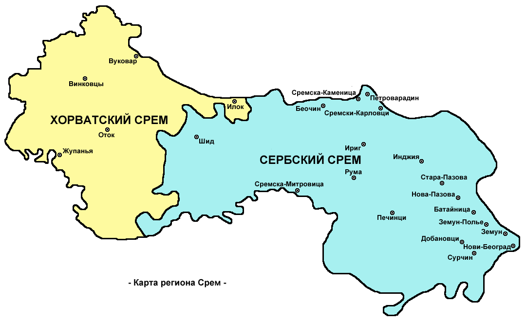
| DescripcióСрем.png |
English: Map of Syrmia region - Russian language version.
Русский: Карта Срема. |
| Data | 4 de juny de 2009 (original upload date) |
| Font | Treball propi |
| Autor | PANONIAN and Tat1642 |
Source and licence
- Original file in English created by User:PANONIAN, translated into Russian by User:Tat1642, improved Russian language version made by User:PANONIAN.
Llicència
| Public domainPublic domainfalsefalse |
| Jo, el titular del copyright d'aquesta obra, l'allibero al domini públic. Això s'aplica a tot el món. En alguns països això pot no ser legalment possible, en tal cas: Jo faig concessió a tothom del dret d'usar aquesta obra per a qualsevol propòsit, sense cap condició llevat d'aquelles requerides per la llei. |

|
This map has been uploaded by Electionworld from en.wikipedia.org to enable the |
English language version - File:Syrmia.png
References
References for historical/geographical borders of Syrmia and modern state borders:
- Školski istorijski atlas, Zavod za izdavanje udžbenika Socijalističke Republike Srbije, Beograd, 1970.
- Milovan Radovanović, Kosovo i Metohija - antropogeografske, istorijskogeografske, demografske i geopolitičke osnove, Beograd, 2008.
- Slobodan Radovanović, Geografski atlas, Magic Map, Smederevska Palanka, 2001.
- Školski geografski atlas, Intersistem Kartografija, Beograd, 2004.
- Denis Šehić - Demir Šehić, Geografski atlas Srbije, Beograd, 2007.
References for sizable cities and towns:
- Popis stanovništva, domaćinstava i stanova u 2002., Stanovništvo, nacionalna ili etnička pripadnost - Podaci po naseljima, knjiga 1, Republika Srbija - Republički zavod za statistiku, Beograd, februar 2003.
- http://world-gazetteer.com/ archive copy at the Wayback Machine
Llegendes
Afegeix una explicació d'una línia del que representa aquest fitxer
Elements representats en aquest fitxer
representa l'entitat
Algun valor sense element de Wikidata
4 juny 2009
image/png
Historial del fitxer
Cliqueu una data/hora per veure el fitxer tal com era aleshores.
| Data/hora | Miniatura | Dimensions | Usuari/a | Comentari | |
|---|---|---|---|---|---|
| actual | 00:06, 22 nov 2009 | | 1.082 × 662 (54 Ko) | PANONIAN | improved map version |
| 22:40, 4 juny 2009 |  | 1.008 × 600 (36 Ko) | Tat1642 | орфография | |
| 22:24, 4 juny 2009 |  | 1.008 × 600 (32 Ko) | Tat1642 | {{ew|en|PANONIAN}} Translated by User:Tat1642 Карта ru:Срема English lanuage version - File:Syrmia.png {{PD-self}} Category:Maps of geographical regions of Vojvodina Category:Maps of geographical regions of Serbia [[Catego |
Ús del fitxer
No hi ha pàgines que utilitzin aquest fitxer.
Ús global del fitxer
Utilització d'aquest fitxer en altres wikis:
- Utilització a be-tarask.wikipedia.org
- Utilització a be.wikipedia.org
- Utilització a ru.wikipedia.org
Obtingut de «https://ca.wikipedia.org/wiki/Fitxer:Срем.png»