File:East-Hem_475ad.jpg
From Wikipedia, the free encyclopedia
Fitxer original (3.240 × 1.903 píxels, mida del fitxer: 753 Ko, tipus MIME: image/jpeg)
| Aquest fitxer i la informació mostrada a continuació provenen del dipòsit multimèdia lliure Wikimedia Commons. |

|
Aquesta imatge (de tipus historical map) s'hauria de tornar a crear utilitzant gràfics vectorials com ara un fitxer SVG. Això té diversos avantatges; en trobareu més informació a Commons:Media for cleanup. Si ja disposeu d'una versió d'aquesta imatge en format SVG, us preguem que la pengeu; després, reemplaceu aquesta plantilla amb la plantilla {{Vector version available|nom nou de la imatge.svg}} en aquesta imatge.
|
 | Aquesta imatge, o les imatges d'aquest article o categoria, ha estat carregada en format JPEG. Tanmateix, conté informació que es podria emmagatzemar més eficaçment o més acuradament en el format PNG o SVG. Si és possible, us preguem que carregueu una versió PNG o SVG d'aquesta imatge sense algoritmes de compressió, derivada d'una font no JPEG o sense codificació de compressió. |  |
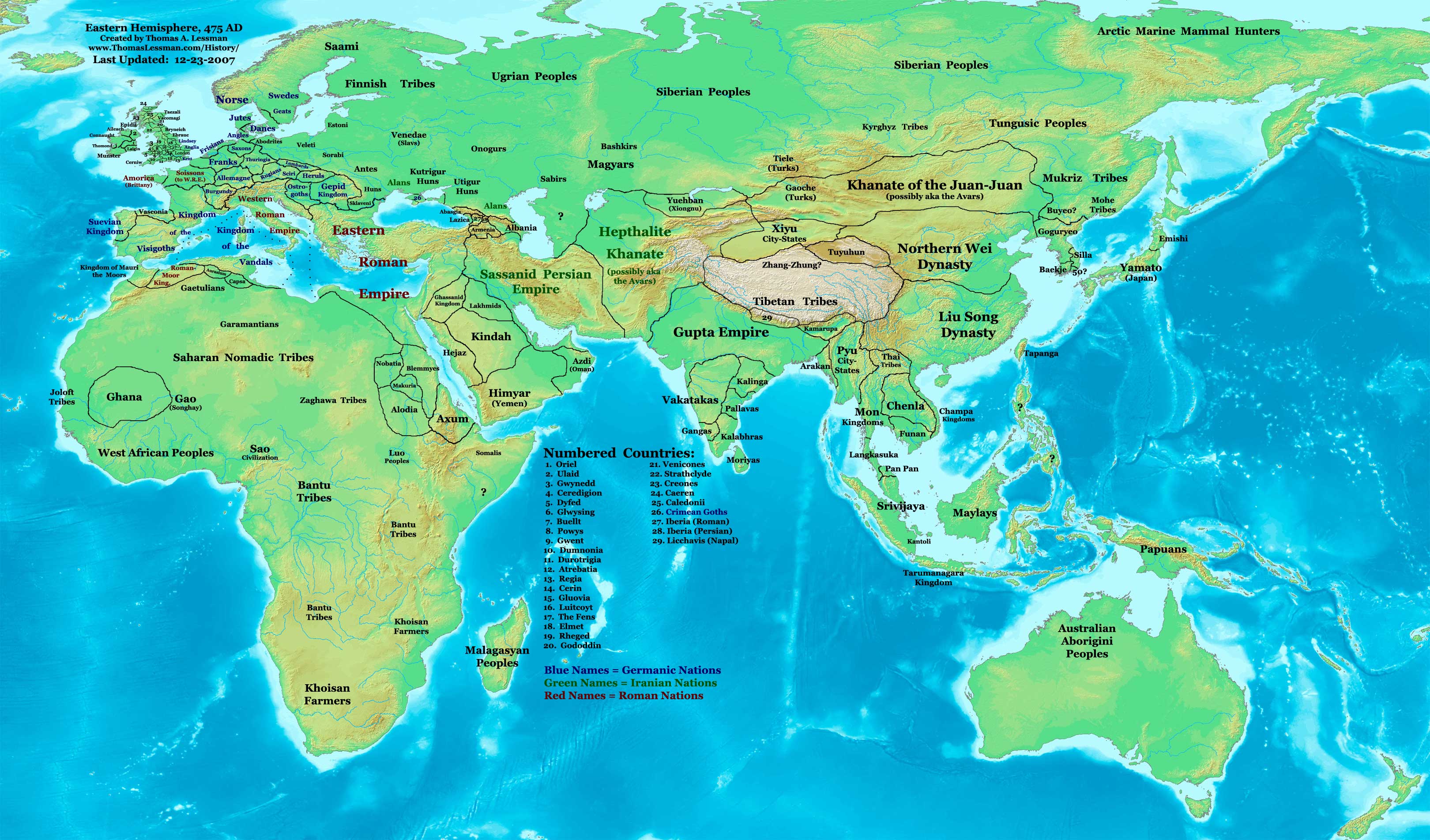
| DescripcióEast-Hem 475ad.jpg | Eastern Hemisphere in 475 AD. |
| Font | self-made (For reference information, see the Map Source References section below.) |
| Autor | Thomas Lessman (Contact!) |
| Permís (Com reutilitzar aquest fitxer) |
Jo, el titular dels drets d'autor d'aquest treball, el public sota la següent llicència: Aquest fitxer està subjecte a la llicència de Creative Commons Reconeixement i Compartir Igual 3.0 No adaptada.
|
| Altres versions |
see the East-Hem 475ad.jpg File History section below.
Map SummaryOriginal Source URL: http://www.thomaslessman.com/History/images/East-Hem_475ad.jpg. This map of the Eastern Hemisphere in 475 AD was created by Thomas Lessman, based on information from the sources listed below. This map is free for educational use (see Permission info above). When using this map, please mention that it is available for free at www.WorldHistoryMaps.info.
Map Source References
References for information contained in this map: 1. Borders of Europe are mostly derived from the Euratlas.com map of Europe in 500 AD. 2. Borders of Britain are derived from the "EarlyBritishKingdoms.com", map of map Britain in 475 AD. 3. Borders of Asian countries derive from various Wikipedia articles and Google history map searches. 4. Some information is derived from Wikimedia's map of The world in 500 CE, created by User:Javierfv1212. 5. Much of the information in this map was cross-checked with Bruce Gordon's Regnal Chronologies. |
Other Historical Maps by Thomas Lessman
| Maps of the eastern hemisphere showing history
Bold dates are available on Wikimedia or Wikipedia. | ||
| Primeval | ||
| Ancient
|
·| 600 BC | 550 BC | 527 BC | 500 BC |
400 BC | ·| 1 AD | 50 AD | 100 AD | 200 AD | 300 AD | | |
| Medieval |
·| 500 AD | 565 AD | 600 AD | 700 AD | | |
| Modern |
·| 1500 AD | · * For historical maps of the whole world, | |
| history links talk edit view | ||
Llegendes
Elements representats en aquest fitxer
representa l'entitat
Algun valor sense element de Wikidata
image/jpeg
Historial del fitxer
Cliqueu una data/hora per veure el fitxer tal com era aleshores.
| Data/hora | Miniatura | Dimensions | Usuari/a | Comentari | |
|---|---|---|---|---|---|
| actual | 17:17, 7 feb 2008 | | 3.240 × 1.903 (753 Ko) | Rottweiler | {{Information |Description= == Summary == Author: Thomas A. Lessman. Source URL: http://www.ThomasLessman.com/History/images/East-Hem_475ad.jpg. Image was created by Thomas Lessman based on historical information located in sources listed below. This map |
Ús del fitxer
No hi ha pàgines que utilitzin aquest fitxer.
Ús global del fitxer
Utilització d'aquest fitxer en altres wikis:
- Utilització a ar.wikipedia.org
- Utilització a ce.wikipedia.org
- Utilització a de.wikipedia.org
- Utilització a el.wikipedia.org
- Utilització a en.wikipedia.org
- Utilització a es.wikipedia.org
- Utilització a fr.wikipedia.org
- Utilització a rue.wikipedia.org
- Utilització a ru.wikipedia.org
- Utilització a sh.wikipedia.org
- Utilització a sv.wikipedia.org
- Utilització a ta.wikipedia.org
Metadades
Aquest fitxer conté informació addicional, probablement afegida per la càmera digital o l'escàner utilitzat per a crear-lo o digitalitzar-lo. Si s'ha modificat posteriorment, alguns detalls poden no reflectir les dades reals del fitxer modificat.
| _error | 0 |
|---|