File:Peel-Commission_Report_Map1_AdminDistrictsSyriaPalestine_1154x1846.png
From Wikipedia, the free encyclopedia

Fitxer original (1.154 × 1.846 píxels, mida del fitxer: 36 Ko, tipus MIME: image/png)
| Aquest fitxer i la informació mostrada a continuació provenen del dipòsit multimèdia lliure Wikimedia Commons. |
| DescripcióPeel-Commission Report Map1 AdminDistrictsSyriaPalestine 1154x1846.png |
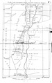
English: Pre-war Turkish Administrative Districts comprised in Syria and Palestine. Map No. 1 of the Peel Commission Report, presented to illustrate the Vilayets and Sandjaks mentioned in the 1915-10-24 en:McMahon Letters (McMahon Pledge, see also en:McMahon–Hussein Correspondence), showing the Ottoman adminstrative divisions.
This is the original scan from the scanned copy of the Peel Report as found on the UNISPAL library of the United Nations. |
||||
| Data | |||||
| Font | Palestine Royal Commission (Peel Commission), Report, Presented by the Secretary of State for the Colonies to Parliament by Command of His Majesty, July 1937. London, His Majesty's Stationary Office, 1937 Download as PDF from UNISPAL:UN.ORG | ||||
| Autor | British War Office, 1937 | ||||
| Permís (Com reutilitzar aquest fitxer) |
|


This file was derived from: Pre-war Turkish Administrative Districts comprised in Syria and Palestine of Peel Commission Report 1937.tif
| Això és una imatge retocada, cosa que vol dir que ha estat alterada digitalment de la seva versió original. Modificacions: Shadows from wrinkles and crinkles which resulted from folding of the original copy have been cleaned out as much as possible. Unfortunately this was done with a reduced version of the original file. In the larger, the TIF, the mouse danced too much. "Upload a new version of this file" was not possible because this one is PNG while the first upload is TIF.
|
Historial del fitxer
Cliqueu una data/hora per veure el fitxer tal com era aleshores.
| Data/hora | Miniatura | Dimensions | Usuari/a | Comentari | |
|---|---|---|---|---|---|
| actual | 13:04, 31 gen 2016 | | 1.154 × 1.846 (36 Ko) | L.Willms | {{Information |Description ={{en|1=Pre-war Turkish Administrative Districts comprised in Syria and Palestine. Map No. 1 of the Peel Commission Report, presented to illustrate the Vilayets and Sandjaks mentioned in the 1915-10-24 [[:en:McMahon Letter... |
Ús del fitxer
No hi ha pàgines que utilitzin aquest fitxer.
Ús global del fitxer
Utilització d'aquest fitxer en altres wikis:
- Utilització a en.wikipedia.org
- Utilització a hy.wikipedia.org
Metadades
Aquest fitxer conté informació addicional, probablement afegida per la càmera digital o l'escàner utilitzat per a crear-lo o digitalitzar-lo. Si s'ha modificat posteriorment, alguns detalls poden no reflectir les dades reals del fitxer modificat.
| Data i hora de modificació del fitxer | 10:06, 31 gen 2016 |
|---|---|
| Resolució horitzontal | 118 ppc |
| Resolució vertical | 118 ppc |