Fitxer:WestAfrica1625.png
From Wikipedia, the free encyclopedia
No hi ha cap versió amb una resolució més gran.
WestAfrica1625.png (498 × 306 píxels, mida del fitxer: 31 Ko, tipus MIME: image/png)
| Aquest fitxer i la informació mostrada a continuació provenen del dipòsit multimèdia lliure Wikimedia Commons. |

|
Aquesta imatge (de tipus historical map) s'hauria de tornar a crear utilitzant gràfics vectorials com ara un fitxer SVG. Això té diversos avantatges; en trobareu més informació a Commons:Media for cleanup. Si ja disposeu d'una versió d'aquesta imatge en format SVG, us preguem que la pengeu; després, reemplaceu aquesta plantilla amb la plantilla {{Vector version available|nom nou de la imatge.svg}} en aquesta imatge.
|
Resum
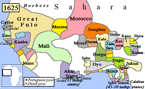
| DescripcióWestAfrica1625.png |
English: Map of West Africa, AD 1625.
(Partially based on Atlas of World History (2007) - Early modern Africa, map.) |
| Data | |
| Font | Treball propi |
| Autor | Gabagool |
Llicència
Jo, el titular dels drets d'autor d'aquest treball, el public sota la següent llicència:
Aquest fitxer està subjecte a la llicència de Creative Commons Reconeixement 3.0 No adaptada.
- Sou lliure de:
- compartir – copiar, distribuir i comunicar públicament l'obra
- adaptar – fer-ne obres derivades
- Amb les condicions següents:
- reconeixement – Heu de donar la informació adequada sobre l'autor, proporcionar un enllaç a la llicència i indicar si s'han realitzat canvis. Podeu fer-ho amb qualsevol mitjà raonable, però de cap manera no suggereixi que l'autor us dóna suport o aprova l'ús que en feu.
Llegendes
Afegeix una explicació d'una línia del que representa aquest fitxer
Elements representats en aquest fitxer
representa l'entitat
Algun valor sense element de Wikidata
19 abr 2009
image/png
Historial del fitxer
Cliqueu una data/hora per veure el fitxer tal com era aleshores.
| Data/hora | Miniatura | Dimensions | Usuari/a | Comentari | |
|---|---|---|---|---|---|
| actual | 19:42, 5 maig 2010 | | 498 × 306 (31 Ko) | Omar-Toons | Reverted to version as of 00:15, 16 June 2009 |
| 20:05, 20 abr 2010 |  | 497 × 306 (31 Ko) | Bokpasa | Saadi dynasty and Tuaregs | |
| 02:15, 16 juny 2009 |  | 498 × 306 (31 Ko) | Gabagool | rm lines | |
| 21:57, 19 abr 2009 |  | 498 × 306 (32 Ko) | Gabagool | {{Information |Description={{en|1=Map of West Africa, AD 1625. (Partially based on ''Atlas of World History'' (2007) - Early modern Africa, map.)}} |Source=Own work by uploader |Author=Gabagool |Date=2009-04-19 |Permission= |other_versi |
Ús del fitxer
Les 8 pàgines següents utilitzen aquest fitxer:
Ús global del fitxer
Utilització d'aquest fitxer en altres wikis:
- Utilització a af.wikipedia.org
- Utilització a als.wikipedia.org
- Utilització a ar.wikipedia.org
- Utilització a azb.wikipedia.org
- Utilització a bn.wikipedia.org
- Utilització a da.wikipedia.org
- Utilització a de.wikipedia.org
- Utilització a en.wikipedia.org
- Mali Empire
- Songhai Empire
- Songhai people
- Sahelian kingdoms
- Oyo Empire
- History of West Africa
- Islamization of the Sudan region
- Kaabu
- Empire of Great Fulo
- Dendi (province)
- Legends of Africa
- Timeline of Nigerian history
- List of kingdoms in Africa throughout history
- Military history of the Mali Empire
- Nigerian traditional rulers
- User:OnBeyondZebrax/sandbox/African history
- User:Tisquesusa/sandbox9
- The Songhai
- User:Catjacket/sandbox
- Medieval and early modern Africa
- Utilització a en.wikibooks.org
- Utilització a es.wikipedia.org
- Utilització a et.wikipedia.org
- Utilització a eu.wikipedia.org
Vegeu més usos globals d'aquest fitxer.
Obtingut de «https://ca.wikipedia.org/wiki/Fitxer:WestAfrica1625.png»