Fitxer:Adams_onis_map.png
From Wikipedia, the free encyclopedia
Fitxer original (800 × 654 píxels, mida del fitxer: 226 Ko, tipus MIME: image/png)
| Aquest fitxer i la informació mostrada a continuació provenen del dipòsit multimèdia lliure Wikimedia Commons. |


Resum
Please state the map from which this was traced, or the other cartographic sources that provided the information allowing you to create the boundaries show.[citation needed]
en:User:Citynoise is the creator at stated at source: I, Citynoise, am the creator of this map and hereby release it per the ShareAlike Attribution license. See www.radicalcartography.net for more.
Llicència
- Sou lliure de:
- compartir – copiar, distribuir i comunicar públicament l'obra
- adaptar – fer-ne obres derivades
- Amb les condicions següents:
- reconeixement – Heu de donar la informació adequada sobre l'autor, proporcionar un enllaç a la llicència i indicar si s'han realitzat canvis. Podeu fer-ho amb qualsevol mitjà raonable, però de cap manera no suggereixi que l'autor us dóna suport o aprova l'ús que en feu.
- compartir igual – Si modifiqueu, transformeu, o generareu amb el material, haureu de distribuir les vostres contribucions sota una llicència similar o una de compatible com l'original
Llegendes
Elements representats en aquest fitxer
representa l'entitat
image/png
f6f9e450b5414ca462750737bf57fc109d1b83e1
231.585 byte
654 píxel
800 píxel
Historial del fitxer
Cliqueu una data/hora per veure el fitxer tal com era aleshores.
| Data/hora | Miniatura | Dimensions | Usuari/a | Comentari | |
|---|---|---|---|---|---|
| actual | 20:56, 18 jul 2012 | | 800 × 654 (226 Ko) | Kmusser | rm Russian claim to Oregon (was dropped by the timeframe of this map - see Adams-Onis talk page) |
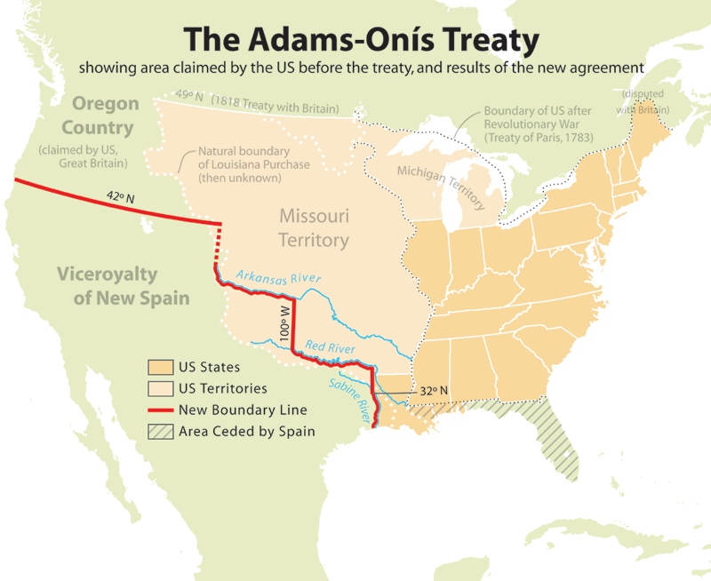
| 21:42, 10 jul 2006 |  | 800 × 654 (227 Ko) | JMPerez~commonswiki | == Summary == Map showing the results of the Adams-Onís Treaty of 1819. I, Citynoise, am the creator of this map and hereby release it per the ShareAlike Attribution license. See www.radicalcartography.net for more. From English Wikipedia. == Licensin |
Ús del fitxer
La pàgina següent utilitza aquest fitxer:
Ús global del fitxer
Utilització d'aquest fitxer en altres wikis:
- Utilització a ar.wikipedia.org
- Utilització a cs.wikipedia.org
- Utilització a da.wikipedia.org
- Utilització a de.wikipedia.org
- Utilització a en.wikipedia.org
- John Quincy Adams
- James Monroe
- Adams–Onís Treaty
- Moses Austin
- Spanish Canadians
- Spanish Texas
- Presidency of James Monroe
- User:Esemono/British
- Territorial evolution of the Caribbean
- List of territorial claims and designations in Colorado
- Early history of the Arkansas Valley in Colorado
- History of U.S. foreign policy, 1801–1829
- Long's Expedition of 1820
- User:Falcaorib/Canada, United States and Mexico
- Utilització a eu.wikipedia.org
- Utilització a fa.wikipedia.org
- Utilització a fi.wikipedia.org
- Utilització a he.wikipedia.org
- Utilització a hu.wikipedia.org
- Utilització a id.wikipedia.org
- Utilització a it.wikipedia.org
- Utilització a ja.wikipedia.org
- Utilització a ko.wikipedia.org
- Utilització a nl.wikipedia.org
- Utilització a no.wikipedia.org
- Utilització a pl.wikipedia.org
- Utilització a pnb.wikipedia.org
- Utilització a pt.wikipedia.org
- Utilització a ro.wikipedia.org
- Utilització a ru.wikipedia.org
- Utilització a simple.wikipedia.org
- Utilització a sr.wikipedia.org
- Utilització a sv.wikipedia.org
- Utilització a th.wikipedia.org
- Utilització a uk.wikipedia.org
- Utilització a ur.wikipedia.org
- Utilització a www.wikidata.org
Vegeu més usos globals d'aquest fitxer.
Metadades
Aquest fitxer conté informació addicional, probablement afegida per la càmera digital o l'escàner utilitzat per a crear-lo o digitalitzar-lo. Si s'ha modificat posteriorment, alguns detalls poden no reflectir les dades reals del fitxer modificat.
| Resolució horitzontal | 28,35 ppc |
|---|---|
| Resolució vertical | 28,35 ppc |