Fitxer:Great_Lakes_1913_Storm_Shipwrecks.png
From Wikipedia, the free encyclopedia
Fitxer original (4.000 × 2.400 píxels, mida del fitxer: 799 Ko, tipus MIME: image/png)
| Aquest fitxer i la informació mostrada a continuació provenen del dipòsit multimèdia lliure Wikimedia Commons. |
Contingut
Resum
| DescripcióGreat Lakes 1913 Storm Shipwrecks.png |
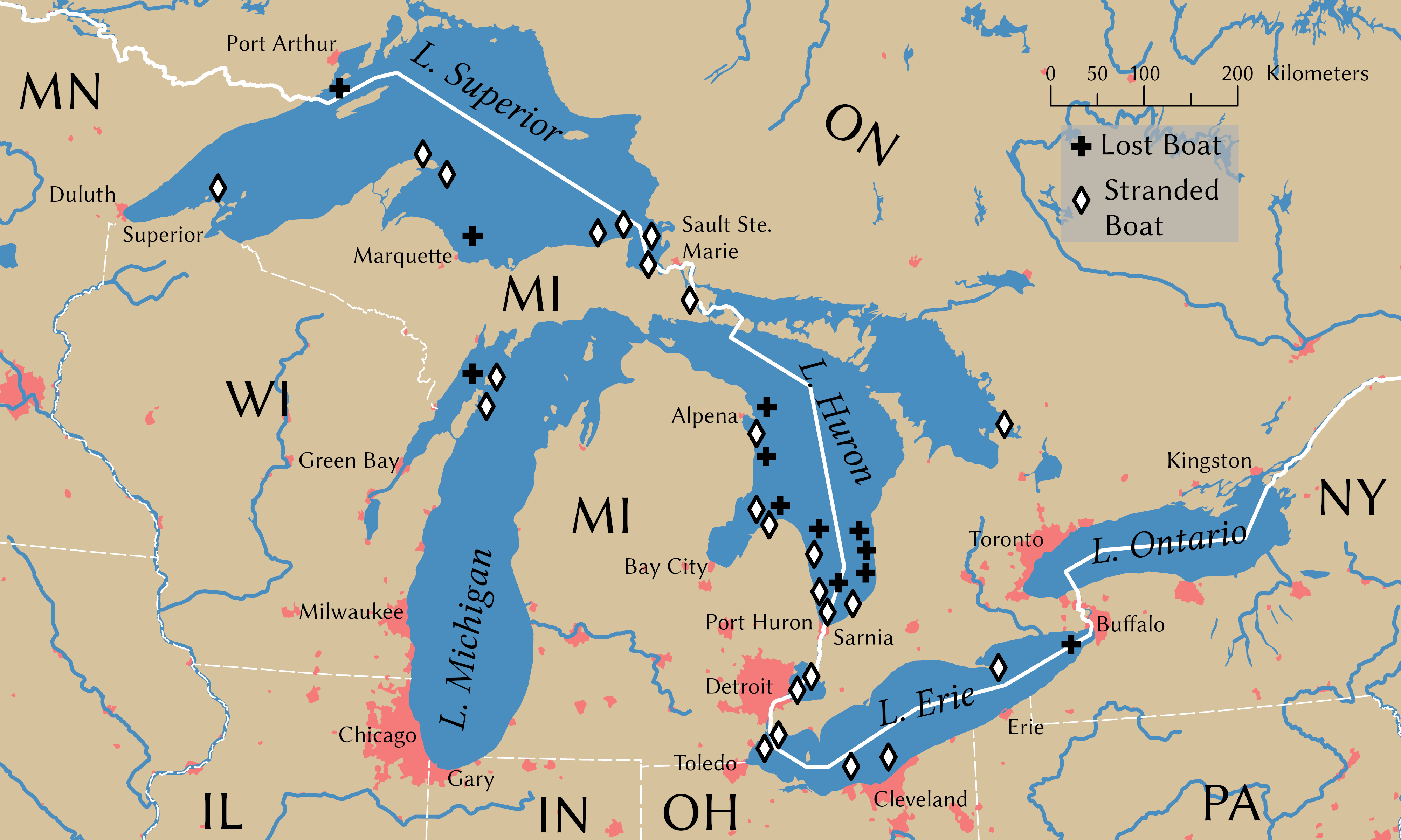
English: Shipwrecks during the Great Lakes Storm of 1913. Wreck locations come from Brown (2002, p. 203) |
||
| Data | |||
| Font | Treball propi | ||
| Creador | |||
| Crèdits d'adquisició | © Tom Fish, geo.fish // Creative Commons BY-SA 4.0 | ||
| Permís (Com reutilitzar aquest fitxer) |
|
||
| Geotemporal data | |||
| Sistema de referència espacial | NAD 1983 Great Lakes Basin Albers [WKID: 31734] | ||
| Escala | 1:11,792,324 | ||
| Archival data | |||
| artwork-references | Brown, David G. (2002) White Hurricane: A Great Lakes November Gale and America's Deadliest Maritime Disaster, International Marine/McGraw-Hill ISBN: 0-07-138037-X. | ||
| PNG genesis InfoField | Aquesta PNG imatge rasteritzada ha estat creada amb ArcGIS Pro |
||
Llicència
Data
Rivers, lakes, and urban areas
| Public domainPublic domainfalsefalse |
| This file uses data that was sourced from Natural Earth, a public domain dataset. From the terms of use:
All versions of Natural Earth raster + vector map data found on this website are in the public domain. You may use the maps in any manner, including modifying the content and design, electronic dissemination, and offset printing. The primary authors, Tom Patterson and Nathaniel Vaughn Kelso, and all other contributors renounce all financial claim to the maps and invites you to use them for personal, educational, and commercial purposes. |
Shipwreck locations
The locations of the shipwrecks are facts and are not eligible for copyright protection
| Public domainPublic domainfalsefalse |
| Aquesta imatge no és apta per tenir drets d'autor perquè consta totalment d'informació que és propietat comuna i no conté cap creació original. Per tant, és en el domini públic. |
International boundary
The international boundaries are sourced from the Large Scale International Boundaries published by the US Department of State
| Public domainPublic domainfalsefalse |
| This image is a work of a United States Department of State employee, taken or made as part of that person's official duties. As a work of the U.S. federal government, the image is in the public domain per 17 U.S.C. § 101 and § 105 and the Department Copyright Information. |  |
State boundary
The state boundaries are sourced from STATE_BOUNDS the United States Geological Survey
| Public domainPublic domainfalsefalse |
Aquesta imatge és de domini públic, ja que conté materials que originalment van venir del Servei Geològic dels Estats Units d'Amèrica, una agència del Departament de l'Interior dels Estats Units. Per a obtenir més informació, consulti la política oficial de drets de l'USGS.
Bahasa Indonesia ∙ català ∙ čeština ∙ Deutsch ∙ eesti ∙ English ∙ español ∙ français ∙ galego ∙ italiano ∙ Nederlands ∙ português ∙ polski ∙ sicilianu ∙ suomi ∙ Tiếng Việt ∙ Türkçe ∙ български ∙ македонски ∙ русский ∙ മലയാളം ∙ 한국어 ∙ 日本語 ∙ 中文 ∙ 中文(简体) ∙ 中文(繁體) ∙ العربية ∙ فارسی ∙ +/− |
Final Map
- Sou lliure de:
- compartir – copiar, distribuir i comunicar públicament l'obra
- adaptar – fer-ne obres derivades
- Amb les condicions següents:
- reconeixement – Heu de donar la informació adequada sobre l'autor, proporcionar un enllaç a la llicència i indicar si s'han realitzat canvis. Podeu fer-ho amb qualsevol mitjà raonable, però de cap manera no suggereixi que l'autor us dóna suport o aprova l'ús que en feu.
- compartir igual – Si modifiqueu, transformeu, o generareu amb el material, haureu de distribuir les vostres contribucions sota una llicència similar o una de compatible com l'original
Llegendes
Elements representats en aquest fitxer
representa l'entitat
Algun valor sense element de Wikidata
image/png
Historial del fitxer
Cliqueu una data/hora per veure el fitxer tal com era aleshores.
| Data/hora | Miniatura | Dimensions | Usuari/a | Comentari | |
|---|---|---|---|---|---|
| actual | 01:54, 9 nov 2021 | | 4.000 × 2.400 (799 Ko) | Guerillero | Remedy copyright issues |
| 21:07, 27 feb 2007 |  | 1.786 × 1.194 (1,05 Mo) | SalomonCeb | Shipwrecks during the en:Great Lakes Storm of 1913. Reference: ''White Hurricane'', by David G. Brown, 2002. All text and icons were added to the PD blank map located at: http://walrus.wr.usgs.gov/infobank/gazette/jpg/regions/fr_glez.jpg {{PD-s |
Ús del fitxer
La pàgina següent utilitza aquest fitxer:
Ús global del fitxer
Utilització d'aquest fitxer en altres wikis:
- Utilització a de.wikipedia.org
- Utilització a de.wiktionary.org
- Utilització a en.wikipedia.org
- Utilització a fr.wikipedia.org
- Utilització a nl.wikipedia.org
- Utilització a ru.wikipedia.org
- Utilització a uz.wikipedia.org
Metadades
Aquest fitxer conté informació addicional, probablement afegida per la càmera digital o l'escàner utilitzat per a crear-lo o digitalitzar-lo. Si s'ha modificat posteriorment, alguns detalls poden no reflectir les dades reals del fitxer modificat.
| Resolució horitzontal | 314,96 ppc |
|---|---|
| Resolució vertical | 314,96 ppc |