Fitxer:National-atlas-pennsylvania.png
From Wikipedia, the free encyclopedia
No hi ha cap versió amb una resolució més gran.
National-atlas-pennsylvania.png (762 × 590 píxels, mida del fitxer: 140 Ko, tipus MIME: image/png)
| Aquest fitxer i la informació mostrada a continuació provenen del dipòsit multimèdia lliure Wikimedia Commons. |
Resum
| DescripcióNational-atlas-pennsylvania.png |
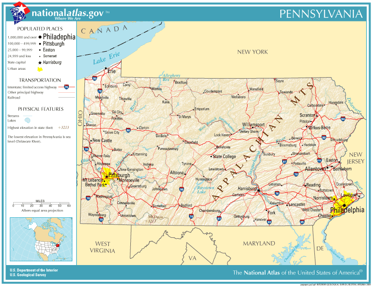
English: Map of Pennsylvania. |
| Data | |
| Font | National Atlas |
| Autor |
Aquest fitxer manca d'informació de l'autor.
|
Llicència
| Public domainPublic domainfalsefalse |
This map was obtained from an edition of the National Atlas of the United States. Like almost all works of the U.S. federal government, works from the National Atlas are in the public domain in the United States.
Online access: NationalAtlas.gov | 1970 print edition: Library of Congress, Perry-Castañeda Library čeština | Deutsch | English | français | Bahasa Indonesia | italiano | македонски | മലയാളം | sicilianu | 中文 | 中文(简体) | 中文(繁體) | +/− |
Llegendes
Afegeix una explicació d'una línia del que representa aquest fitxer
Elements representats en aquest fitxer
representa l'entitat
11 set 2005
image/png
Historial del fitxer
Cliqueu una data/hora per veure el fitxer tal com era aleshores.
| Data/hora | Miniatura | Dimensions | Usuari/a | Comentari | |
|---|---|---|---|---|---|
| actual | 21:10, 14 oct 2005 | | 762 × 590 (140 Ko) | Warden | Reverted to earlier revision |
| 20:19, 11 set 2005 |  | 762 × 590 (140 Ko) | Shauni | {{PD-USGov-Atlas}} Category:Maps of Pennsylvania |
Ús del fitxer
La pàgina següent utilitza aquest fitxer:
Ús global del fitxer
Utilització d'aquest fitxer en altres wikis:
- Utilització a ast.wikipedia.org
- Utilització a bn.wikipedia.org
- Utilització a da.wikipedia.org
- Utilització a en.wikipedia.org
- Utilització a es.wikipedia.org
- Utilització a io.wikipedia.org
- Utilització a ja.wikipedia.org
- Utilització a mk.wikipedia.org
- Utilització a mr.wikipedia.org
- Utilització a new.wikipedia.org
- Utilització a nl.wikipedia.org
- Utilització a ru.wikipedia.org