Fitxer:NorthSeaCurrents.png
From Wikipedia, the free encyclopedia
Mida d'aquesta previsualització: 458 × 599 píxels. Altres resolucions: 183 × 240 píxels | 367 × 480 píxels | 587 × 768 píxels | 783 × 1.024 píxels | 1.300 × 1.700 píxels.
Fitxer original (1.300 × 1.700 píxels, mida del fitxer: 3,43 Mo, tipus MIME: image/png)
| Aquest fitxer i la informació mostrada a continuació provenen del dipòsit multimèdia lliure Wikimedia Commons. |
Resum
| DescripcióNorthSeaCurrents.png |
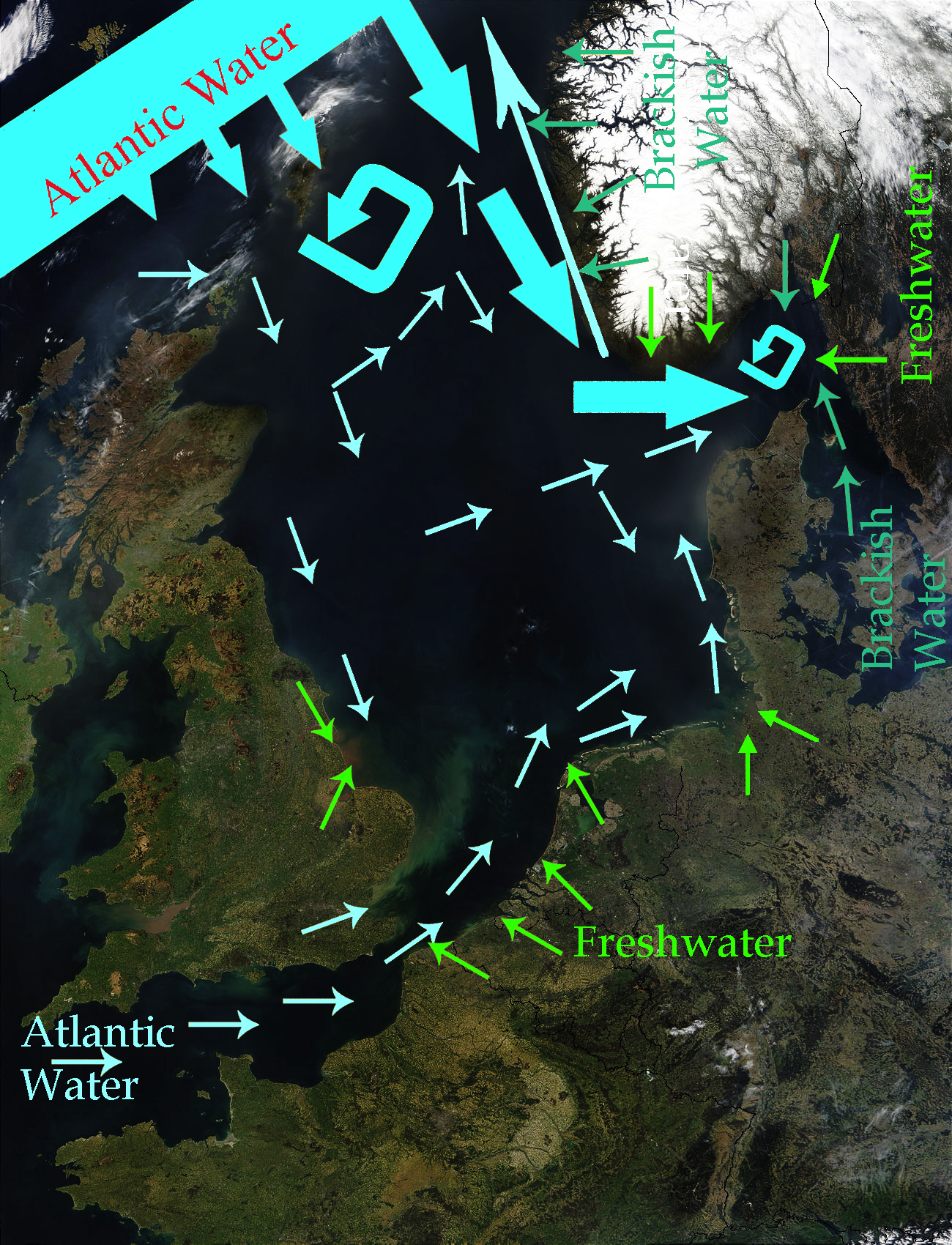
English: North Sea Map derived from NASA satellite image. This image depicts the currents in the North Sea. The intensive light blue broad arrows show the current and amount of flow from the Atlantic Ocean entering the northern area of the North Sea The smaller pale yellow arrows represent the current from the Atlantic Ocean entering through the English Channel. The bluish green arrows represent brackish water from fjords and the Baltic Sea. The green arrows represent freshwater from various rivers which drain land areas and discharge into the North Sea. Sources used to base this map upon were Safety at Sea currents and North Sea physiography (depth distribution and main currents) Guide to the Oceans By John Pernetta page 184 It would be nice to re-do this map with wiggly flowing arrows for the water currents. |
| Data | 2009-01-22, recoloured in 2014-04-27 |
| Font | Derivative work from File:NASA NorthSea1 2.jpg |
| Autor | SriMesh, recoloured by Ulamm (talk) 22:29, 27 April 2014 (UTC) |
| Altres versions |
• File:North-Sea-Labels.jpg • NorthSeaCurrents,jpg, the original presentation of the currents |
Llicència
Jo, el titular dels drets d'autor d'aquest treball, el public sota les següents llicències:
Aquest fitxer està subjecte a la llicència de Creative Commons Reconeixement i Compartir Igual 3.0 No adaptada.
- Sou lliure de:
- compartir – copiar, distribuir i comunicar públicament l'obra
- adaptar – fer-ne obres derivades
- Amb les condicions següents:
- reconeixement – Heu de donar la informació adequada sobre l'autor, proporcionar un enllaç a la llicència i indicar si s'han realitzat canvis. Podeu fer-ho amb qualsevol mitjà raonable, però de cap manera no suggereixi que l'autor us dóna suport o aprova l'ús que en feu.
- compartir igual – Si modifiqueu, transformeu, o generareu amb el material, haureu de distribuir les vostres contribucions sota una llicència similar o una de compatible com l'original

|
S'autoritza la còpia, la distribució i la modificació d'aquest document sota els termes de la llicència de documentació lliure GNU versió 1.2 o qualsevol altra versió posterior que publiqui la Free Software Foundation; sense seccions invariants, ni textos de portada, ni textos de contraportada. S'inclou una còpia d'aquesta llicència en la secció titulada GNU Free Documentation License.http://www.gnu.org/copyleft/fdl.htmlGFDLGNU Free Documentation Licensetruetrue |
Podeu seleccionar la llicència que vulgueu.
Llegendes
Afegeix una explicació d'una línia del que representa aquest fitxer
Elements representats en aquest fitxer
representa l'entitat
Historial del fitxer
Cliqueu una data/hora per veure el fitxer tal com era aleshores.
| Data/hora | Miniatura | Dimensions | Usuari/a | Comentari | |
|---|---|---|---|---|---|
| actual | 00:56, 28 abr 2014 | | 1.300 × 1.700 (3,43 Mo) | Ulamm | once more |
| 00:48, 28 abr 2014 |  | 1.300 × 1.700 (3,47 Mo) | Ulamm | more freshwater arrows | |
| 00:29, 28 abr 2014 |  | 1.300 × 1.700 (3,47 Mo) | Ulamm | == {{int:filedesc}} == {{Information |Description={{en|1=''North Sea Map'' derived from NASA satellite image. This image depicts the currents in the North Sea. The dark yellow broad arrows show the current and amount of flow from the Atlantic Ocean en... |
Ús del fitxer
La pàgina següent utilitza aquest fitxer:
Ús global del fitxer
Utilització d'aquest fitxer en altres wikis:
- Utilització a azb.wikipedia.org
- Utilització a cs.wikipedia.org
- Utilització a cy.wikipedia.org
- Utilització a en.wikipedia.org
- Utilització a es.wikipedia.org
- Utilització a fi.wikipedia.org
- Utilització a hak.wikipedia.org
- Utilització a hr.wikipedia.org
- Utilització a vi.wikipedia.org
Metadades
Aquest fitxer conté informació addicional, probablement afegida per la càmera digital o l'escàner utilitzat per a crear-lo o digitalitzar-lo. Si s'ha modificat posteriorment, alguns detalls poden no reflectir les dades reals del fitxer modificat.
| Programari utilitzat |
|
|---|